 River Callahan
Start at the Northeast Entrance, walk the Door and Window trails before the heat builds, then drive the Badlands Loop Road west with the overlooks in order, and save Sage Creek Rim Road for the late afternoon wildlife. That sequence, in that order, is the simplest good first day in Badlands National Park: the two short trails teach you how to read the formations up close, the paved loop gives you the scale, and the gravel west side gives you the animals. Everything else in this guide exists to help you time those three pieces well.
Quick Facts
- Location: Southwestern South Dakota, off Interstate 90, with entrances near Cactus Flat (Exit 131), Wall (Exit 110) and Interior.
- Park size: About 244,000 acres of eroded buttes, pinnacles and mixed grass prairie, per the National Park Service.
- Entrance fee: $30 per private vehicle, $25 per motorcycle and $15 per person on foot or bike, each valid for 7 days; the park annual pass is $55 and the park is cashless, so bring a card or buy ahead on Recreation.gov (NPS fee schedule, checked today).
- First trails to walk: Door Trail, about 0.75 miles round trip, and Window Trail, about 0.25 miles, sharing one parking area near the Ben Reifel Visitor Center.
- Main scenic drive: The Badlands Loop Road, Highway 240, roughly 30 miles of paved road linking the northeast and Pinnacles entrances.
- Wildlife road: Sage Creek Rim Road, an unpaved gravel road on the west side, best for bison, prairie dogs and bighorn sheep in dry weather.
- Gateway towns: Wall, home of Wall Drug, to the northwest, and Interior, a small community just south of the visitor center.
What should a first timer do first at Badlands?
Do the Door and Window trails first, before any long drive. Both start from the same parking area a short distance from the Ben Reifel Visitor Center, and together they take under an hour at an easy pace. The Window Trail is a short boardwalk stroll of about a quarter mile to a natural opening in the Badlands Wall that frames a canyon view. It is the gentlest possible introduction, and it works for almost every visitor, including families with small children and anyone wary of rough ground.
The Door Trail is the one that changes how the rest of the day feels. It begins as a boardwalk, passes through a narrow opening in the wall, the door itself, and then continues as a marked route across the eroded surface beyond. On the boardwalk you are looking at the formations. Past the door you are standing inside them, surrounded by striped spires and dry washes, with the prairie suddenly out of sight. Allow about 45 minutes if you continue beyond the boardwalk, carry water even for this short walk, and turn back at the numbered markers if the surface feels uncertain underfoot.
From the same trailhead area, the Notch Trail is the adventurous option: about 1.5 miles round trip, with a log ladder to climb and exposed edges near the end, finishing at a view over the White River Valley. It is a poor choice in wet weather, when the clay surface turns slick, and it is not suitable for anyone uncomfortable with heights. The Fossil Exhibit Trail, another short boardwalk loop near the visitor center, covers the park fossil story with replica casts and ranger panels, and pairs well with a visit to the working fossil preparation laboratory inside the visitor center, where paleontologists prepare specimens found in the park.
How does the Badlands Loop Road fit together?
The Loop Road is the park backbone, and driving it east to west after the morning trails keeps the sun increasingly behind you at the major overlooks. Big Badlands Overlook, close to the Northeast Entrance, is the first wide view and the place to understand the geography: the wall runs for miles, separating the upper prairie from the lower prairie and the White River Valley. Pinnacles Overlook, near the western end, is the classic late day stop, with layered ridges running to the horizon. Between them, Yellow Mounds Overlook shows the soft, rounded, yellow and purple hills of an older formation, a complete change of texture from the sharp spires near the Door Trail.
Build the drive around stops rather than treating it as a transit. Two to three hours with stops is a realistic allowance for the paved loop alone. There is no fuel and no food service along the road itself, so start with a full tank and your own water and snacks. Cell coverage is unreliable in the lower sections. If you are planning a longer walking day, the Castle Trail, the park longest developed trail at about 10 miles round trip between the Door and Window parking area and the Fossil Exhibit Trail area, crosses flat prairie and formation edges and can be shortened by arranging a pickup, but for most first timers a section of it is enough.
For more hiking ideas in a very different eastern landscape, compare the ridge walks in our guide to Shenandoah Skyline Drive day hikes, and for another wall walk with a long history, see our two day Hadrian’s Wall plan.
Why is Sage Creek Rim Road worth the gravel?
Because it is where the park stops being a viewpoint and becomes a prairie. Sage Creek Rim Road leaves the paved loop near Pinnacles and runs west along the rim above Sage Creek, through open grassland where the park bison herd ranges. Roberts Prairie Dog Town, a large colony beside the road, is one of the most reliable wildlife stops in the park: black tailed prairie dogs stand sentry, bark and dive between burrows, and the predators that hunt them, from coyotes to raptors, are drawn to the same ground. Black footed ferrets, reintroduced here after being thought extinct, are nocturnal and almost never seen, but the colony is part of their habitat story, which rangers tell well.
The road is gravel and can be rough, washboarded or impassable after rain, and it is not a shortcut: it eventually leads out toward the small community of Scenic and Highway 44. Check conditions at the visitor center before committing, keep a generous distance from bison even when they wander close to the road, and never approach on foot for a photograph. Near the west end of the road, Sage Creek Campground offers a small number of free, first come sites with pit toilets and no water, a very different night from the developed options near Cedar Pass.
Where should you base yourself, Wall or Interior?
Wall is the practical base for most first timers. It sits just north of the Pinnacles Entrance on Interstate 90, has the widest choice of motels, fuel and food, and is home to Wall Drug, the sprawling roadside store that began by offering free ice water to travellers in the 1930s and now functions as a small town within the town. Staying in Wall makes an early start at Pinnacles Overlook and Sage Creek easy, but it puts the Door and Window trailhead, at the far eastern end of the loop, at the end of a longer morning drive.
Interior, and the Cedar Pass area beside the visitor center, suit visitors who want the trails first. Cedar Pass Lodge is the only lodging inside the park, a set of cabins near the visitor center, and the adjacent Cedar Pass Campground is the main developed campground, with seasonal services. From here the Door, Window, Notch and Fossil Exhibit trails are minutes away, sunrise on the formations is a short walk rather than a drive, and the Minuteman Missile National Historical Site, which preserves a Cold War missile silo and launch control facility, is a short drive east along the interstate corridor for a complete change of subject. Book in park and Wall lodging well ahead for summer, when the park is at its busiest and hottest.
When is the best time of day, and the best season?
Early morning and the last two hours of light are the hours that matter. Midday in summer flattens the colours, pushes temperatures on the exposed trails to uncomfortable levels and empties the prairie of visible wildlife. The formations are sedimentary layers laid down tens of millions of years ago and now eroding at roughly an inch a year, among the fastest rates anywhere, and low sun rakes across those layers so the reds, tans and greys separate clearly. Photographers plan around Pinnacles and Big Badlands overlooks at opposite ends of the day for exactly this reason.
Late spring and early autumn are the forgiving seasons: warm days, cool nights and fewer storms. Summer brings the full ranger programme, including evening and night sky events in a park with very dark skies, but also heat that closes down midday hiking plans. Winter is quiet and stark, with short days, icy boardwalks and the possibility of road closures after snow. Whatever the season, the standard Badlands kit is unglamorous and essential: more water than you think you need, a hat, sun protection, and a layer for wind on the rim.
Frequently asked questions
How long do you need for a first visit to Badlands National Park?
One full day covers the Door and Window trails, the Loop Road and Sage Creek Rim Road without rushing. Two days let you add the Notch or a Castle Trail section, the fossil laboratory, and a second wildlife pass at dawn or dusk.
Is there a reservation or timed entry system at Badlands?
No. Entry is through the entrance stations on a standard pass, valid for 7 days, and the park is cashless, so pay by card or buy your pass in advance through Recreation.gov.
Are the Door and Window trails accessible?
The Window Trail is a short boardwalk route and the Door Trail begins as a boardwalk to the opening in the wall. Beyond the door, the Door Trail continues over uneven eroded ground. Check current trail conditions at the Ben Reifel Visitor Center on the day.
Can you see bison at Badlands National Park?
Yes. The herd ranges mainly in the western part of the park, and Sage Creek Rim Road is the most reliable place to look, especially early and late in the day. Always watch from the road or your vehicle and keep a wide distance.
What is Wall Drug and is it worth a stop?
Wall Drug is a famous roadside store in Wall, South Dakota, that grew from a 1930s pharmacy offering free ice water to passing motorists. It is a piece of American road trip history and a practical stop for food, fuel and supplies before or after the park.
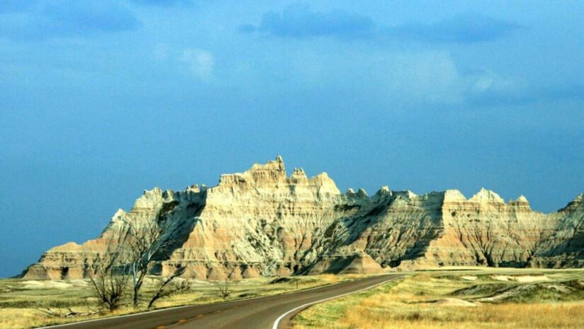
Featured image: Badlands National Park formations above the Loop Road, South Dakota. Photo by Matan Levanon on Unsplash, via the captioned hosted copy at Sunny Sports. Unsplash License.