 Kwame Mensah
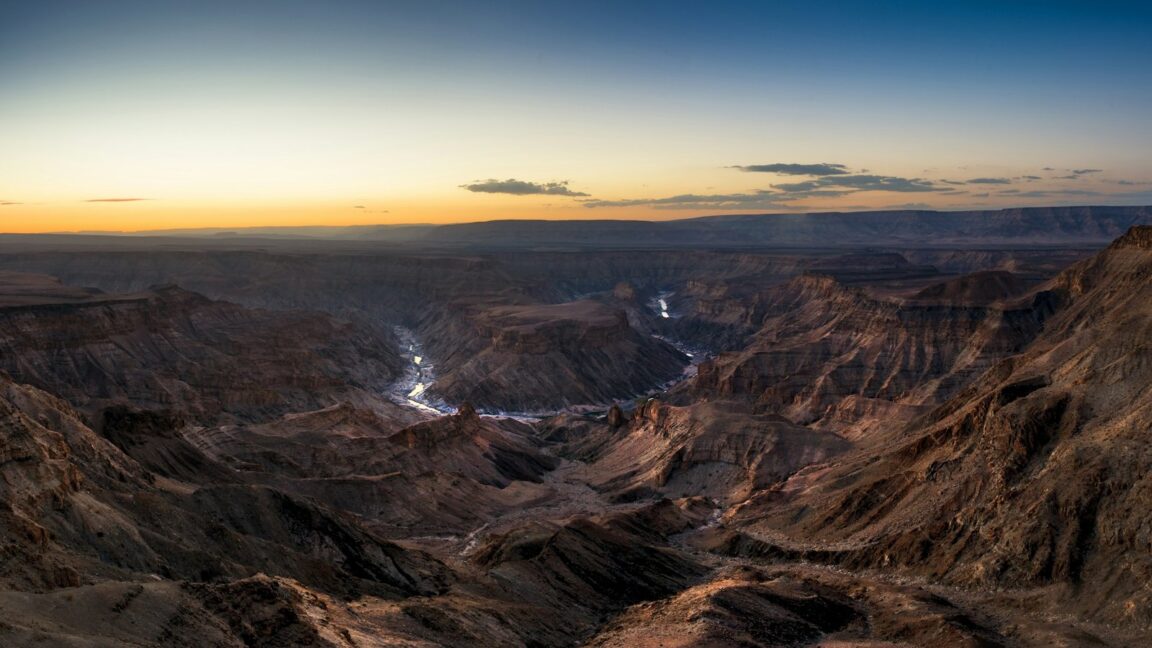
Namibia’s Fish River Canyon hike is a four to five day, roughly 85 to 86 kilometre walk along the canyon floor from Hobas to Ai Ais, and it is governed by three rules that no amount of fitness can negotiate: it opens only in the cool season, from 1 May to 15 September, it requires a medical certificate of fitness presented at Hobas, and it is walked in a group of at least three and at most thirty, carrying everything, with no facilities, no resupply and no marked trail once the descent is done. The canyon rewards that strictness completely. At up to about 160 kilometres long, 27 kilometres wide and 550 metres deep, it is the largest canyon in Africa, and the trail walks inside it, along the river’s chain of pools, for days at a time. This guide explains the season, the certificate, the shuttle logistics between Hobas and Ai Ais, and the water reality that decides what goes in your pack.
Quick Facts
- Route: Hobas (Hikers View Point) to Ai Ais Hot Springs, southern Namibia, inside the Ai Ais Richtersveld Transfrontier Park
- Distance and duration: About 85 to 86 km, usually completed in 5 days (4 days for fast, experienced groups)
- Season: 1 May to 15 September only. Permits are not issued outside this window
- Permits: Booked in advance through Namibia Wildlife Resorts (NWR). Bookings for the following season open on 1 May
- Group and age rules: Minimum group of 3, maximum 30 per day, minimum age 12
- Medical certificate: Required. A doctor signed certificate of fitness, widely specified as no more than 40 days old at the hike start, presented at Hobas
- Facilities on trail: None. No huts, no campsites, no shops, no fires allowed. You carry everything and sleep on the sand
- Water: From the Fish River itself, which runs as a chain of pools in season. Purification is recommended throughout
Why is the trail only open from May to September?
Heat closes this trail, and the numbers explain why no exception is made. In the southern summer the canyon floor becomes one of the hottest walking environments in Africa, with daytime temperatures cited up to 48 degrees Celsius and nights around 30, in a gorge with no shade infrastructure, no water taps and no quick exit. Summer is also the rainy season upstream, and the Fish River, dry or reduced to pools for most of the year, can flood in late summer, turning the trail’s riverbed route into a hazard of an entirely different kind. The 2026 season made the point in the open season itself, when flooding closed the trail from late June until it reopened on 17 July, with slippery crossing rocks flagged on reopening.
The permitted window, 1 May to 15 September, is the Namibian winter, and it is chosen with precision. May can still be warm in the afternoons. June and July bring the coolest, most stable walking, with cold nights that can drop toward 5 degrees. Early September walks well but warms up, and by the middle of the month the gate closes regardless of how mild the year feels. Plan the trip around the window, not around your leave calendar, and treat any source suggesting an April or October hike on the canyon floor as simply wrong: rim viewpoints near Hobas are open all year, but descent is for permitted hikers in season only.
The medical certificate rule, step by step
Every hiker must present a certificate of fitness, completed and signed by a medical doctor, at the Ministry of Environment and Tourism offices at Hobas before descending. NWR sends the medical form with the booking process, and the specification repeated across operator and guide sources is that the certificate must be recent, no more than 40 days old when the hike starts. That timing is the trap that catches organised people: a certificate obtained when you book, months ahead, will be stale by the trailhead. Book the permit first, then book the doctor’s appointment to fall inside the 40 day window, carry the printed certificate with your permit paperwork, and expect to complete indemnity forms and next of kin details at Hobas as part of the same check in.
The rule exists because of what the trail cannot do. There is no routine rescue infrastructure inside the gorge, one recognised emergency exit climbs out near Palm Springs, usually reached around the third day, and a hiker who becomes unwell between descents is a problem measured in days. The certificate, the minimum group of three, and the maximum of thirty starts a day are one system, designed so that nobody walks this canyon alone, unvetted, or in an unmanaged crowd.
Shuttle logistics: Hobas, Ai Ais and the car problem
The hike is a one way line between two places about 70 kilometres apart by road, and the standard solution is to organise your life around Ai Ais. Most groups leave their vehicles at Ai Ais, the hot springs resort at the southern end where the trail finishes, and take the shuttle north to Hobas, a run of roughly 70 to 80 kilometres, so that the hike ends at their own cars, showers and the springs themselves. The alternative is to be dropped at Hobas and arrange the return shuttle from Ai Ais at the end. Either way, the shuttle is booked in advance through NWR at Ai Ais and runs on a schedule, commonly described as roughly every three hours in season, not on demand. There is a second, shorter shuttle leg to understand as well: the trailhead itself, Hikers View Point, sits about 13 kilometres west of Hobas, and groups are transferred out to it after check in formalities.
Fees move by year and should be confirmed at booking, but the structure is stable: a per person hiking permit, reported around N$500 to N$540 in recent seasons, plus daily park entry fees, plus the shuttle legs, each charged per person. Build the budget from those three lines, confirm the current figures with NWR when you reserve, and keep cash flexibility for the conservation fee formalities at Hobas that trip reports consistently mention. For the desert drive that frames this trip, see our guide to Swakopmund, the dunes and the Skeleton Coast, and for another permit governed desert walk on a different continent, our explainer on the Uluru base walk and Field of Light rules.
The descent, the route and the water reality
The trail begins with its most concentrated hour. From the car park at Hikers View Point, the path drops about 500 metres in a little over a kilometre, with chains bolted into the rock for the steepest first hundred metres or so. Both hands free, a trekking pole earned, and no heroics with a full pack: most groups take close to an hour to reach the river floor at the beach below. After that, the canyon is the trail. There is no marked path to follow in the way a European hiker expects. You walk south along the river, choosing your line through boulder fields, deep sand and gravel banks, sleeping wherever a bend offers a sheltered sand beach, and navigating by the canyon itself, which permits only one direction of travel.
Water is the planning discipline that sits underneath every day. In season the Fish River runs as a thinning chain of long pools rather than a flowing river for much of its length, stronger early in the season and drier by September. Hikers drink from the river, and the standing advice is to purify, with tablets or a filter, rather than trust appearance. The corollary is capacity: carry enough bottles or bladder space to load up at a good pool and walk dry stretches without anxiety, fill at every reliable opportunity, and expect pack weights, commonly 14 to 18 kilograms all in, to swing with the water you are carrying that day. Food is entirely self carried for four to five days, open fires are not allowed, so a small stove is standard, and everything, including every wrapper, walks out with you to Ai Ais.
How the five days usually fall
Day 1 is the Hobas formalities, the shuttle to Hikers View Point, the chained descent, and a short first walk along the river to an early camp, because the descent eats the morning. Days 2 and 3 settle into the canyon’s rhythm, long sandy and bouldery kilometres between pools, passing the narrowest sections on the way toward Sulphur Springs, also called Palm Springs, near where the emergency exit climbs out. Day 4 widens as the lower canyon opens, and Day 5 walks the final stretch into Ai Ais, where the hot springs pools, at the resort whose name means place of burning water in the Nama language, provide the most earned soak in African hiking. Fast groups compress the route into four days by walking longer hours, but the five day pattern suits the heat curve of the day, early starts, a shaded midday pause, and an afternoon push, far better.
Frequently Asked Questions
When is the Fish River Canyon hiking trail open?
From 1 May to 15 September each year, and only then. Namibia Wildlife Resorts issues no permits outside that window because of extreme summer heat on the canyon floor, up to about 48 degrees, and late summer flood risk. The rim viewpoints at Hobas remain open all year.
What medical certificate do I need, and when must it be signed?
A certificate of fitness completed by a medical doctor, presented at Hobas before you descend. Operator guidance widely specifies it should be no more than 40 days old at the start of the hike, so schedule the appointment after booking, inside that window, and carry a printed copy.
How big must my group be to get a permit?
At least three hikers and at most thirty starting per day, with a minimum age of 12. Solo hikers and pairs need to join or form a group of three or more before NWR will permit the hike.
How do the Hobas and Ai Ais shuttles work?
Book them in advance through NWR. Most groups leave vehicles at Ai Ais, shuttle north to Hobas, check in, then transfer about 13 km to Hikers View Point to start, and finish the hike back at their vehicles in Ai Ais. Shuttles run on a schedule in season, so confirm times when you book.
Where do hikers get drinking water on the trail?
From the Fish River, which flows as a chain of pools through the hiking season. Purify it with tablets or a filter, carry enough capacity for dry stretches between pools, and fill up at every good opportunity, especially late in the season when the pools shrink.
Are there huts, campsites or shops on the trail?
No. There are no facilities of any kind between the descent and Ai Ais. Hikers carry all food, shelter and equipment, sleep on sand beaches, cook on stoves because open fires are banned, and carry all waste out.