 Jonas Lindqvist
Senja is Norway’s second largest island and the Arctic trip for travellers who find Tromso busy and Lofoten booked out. Its outer coast is a wall of jagged peaks dropping straight into the Norwegian Sea, cut by fjords with a fishing village at the end of each one, and threaded by a 102 km National Scenic Route. Give it three nights if you can. Two is the working minimum for the scenic route and one serious hike, and the island’s weather, which can close the view for a day at a time, argues for a spare half day in hand.
Quick Facts
- Where: Senja Island, Troms county, northern Norway, at about 69 degrees north, linked to the mainland by the Gisund Bridge at Finnsnes.
- Size: About 1,586 square kilometres, the second largest island in Norway outside Svalbard.
- The drive: National Scenic Route Senja, 102 km between Gryllefjord and Botnhamn, with detours to Husoy and Mefjordvaer.
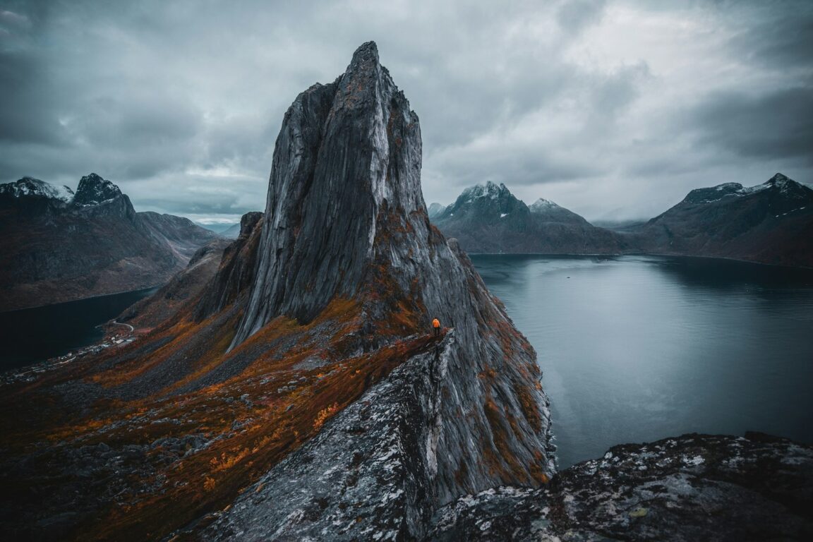
- Signature peak: Segla, 639 metres, above the village of Fjordgard. The classic photograph of it is taken from neighbouring Hesten.
- Light seasons: Midnight sun roughly late May to late July. Aurora season roughly September to early April. Polar night in midwinter.
- Gateway: Tromso is the main airport. The drive via Finnsnes takes about three hours. Bardufoss Airport is closer with limited routes.
- How long: Three nights on the outer coast, based in one village, beats moving every day.
Why does Senja feel wilder than Tromso?
Because the settlement pattern never thickened. Senja’s roughly eight thousand residents spread across an island of fjords and peaks, and its villages, places like Mefjordvaer, Senjahopen, Husoy and Gryllefjord, are working fishing communities first and visitor bases second. The inland side is comparatively soft, birch woods, farms and sheltered water. The outer coast is the drama, and it is reached through tunnels that pop out above a new fjord every few minutes. Readers comparing Arctic Norway options should start with our guide to the Lofoten Islands, then understand Senja as the same geology with the volume turned down, fewer restaurants, fewer beds, and viewpoints you often have to yourself outside July.
How should you drive the National Scenic Route?
In one unhurried day, west to east or east to west, stopping at the built viewpoints that make this road famous. At Bergsbotn, a long wooden platform cantilevers above the Bergsfjord, framing the peaks across the water. At Tungeneset, a boardwalk crosses the shore rocks facing Okshornan, the sawtooth ridge nicknamed the Devil’s Teeth, with tidal pools in the foreground that mirror the peaks at calm sunset. Between them sits Ersfjordstranda, a white sand Arctic beach whose gilded toilet building has become an unlikely landmark.
Detours earn their fuel. Husoy is a village packed onto a small island in the Oyfjord, joined to Senja by a causeway, its houses stacked around a working harbour. Mefjordvaer, at the end of the road below Segla, is the natural lunch stop. Fill up with fuel and food in Finnsnes or Silsand before committing to the outer coast, because shops on the route are small, seasonal and sometimes closed on Sundays.
Segla or Hesten, which hike should you choose?
Both start at Fjordgard, and the honest answer depends on what you want from the photograph and the climb. Segla itself is the curved fin of rock that has become Senja’s symbol. Its hike runs about 5 km return with roughly 600 metres of ascent, takes three to four hours, and finishes on a summit ridge with a sheer drop on the north side. In wet weather the upper path is slippery and exposed, and the usual season is roughly June to September.
Hesten, the smaller mountain opposite, is where the famous image is actually made, Segla rising like a wave across the fjord with water on both sides. It is shorter, about two to three hours return, less exposed, and the better choice for nervous heights or a shorter weather window. The gentler alternative is Husfjellet near Skaland, a wide summit walk with big views over Bergsfjord and Okshornan. Whichever you pick, check the forecast on Yr and, outside summer, the avalanche warnings before leaving, because Senja weather turns fast and low cloud can sit on the peaks for days.
How do you plan honestly for aurora and daylight?
Senja sits under the auroral oval, which makes it one of the more reliable northern lights locations in Europe, and the outer coast has almost no light pollution. From about September to early April, any clear dark night gives fair odds, and viewpoints such as Tungeneset and Bergsbotn face north over open water. It remains a weather game, not a guarantee, and the equinox months are statistically strong. In December and January the polar night means the sun never clears the horizon, though a few hours of blue twilight still light the fjords beautifully, and winter driving on icy roads with storm closures is a serious undertaking.
Summer inverts everything. The midnight sun runs from about late May to late July, hikes can start at ten in the evening, and the summer ferry between Gryllefjord and Andenes links Senja to Vesteraalen, chaining the island into a longer northern road trip. Shoulder season travellers should pack for both islands at once, dark sky hopes and wet trail reality. Our winter packing system for Iceland in what to pack for Iceland in winter transfers to Senja with almost no changes.
Where should you sleep and eat?
Base once and drive out. The outer coast villages hold the atmosphere, harbourside apartments and cabins at Mefjordvaer under the wall of Segla, a long established hotel and cabin settlement at Hamn i Senja on the Bergsfjord, and scattered holiday homes around Fjordgard, Skaland and Bovaer. Finnsnes and Silsand on the inland side offer more choice, larger supermarkets and lower prices, at the cost of a daily commute through the tunnels to the coast. Book early for summer, because the outer coast bed stock is small and July sells out.
Eating follows the same pattern. A handful of village restaurants and cafes serve excellent local fish, including fish soup and cod landed by the boats you can watch from the harbour, but many open seasonally and close early in the evening. The standard local strategy is self catering with one or two meals out, stocking up in Finnsnes before crossing the bridge. Travellers who plan Senja as a cooking trip in a cabin, with the scenic route as the daily entertainment, tend to leave happiest.
Frequently Asked Questions
How do you get to Senja from Tromso?
Drive via Finnsnes and the Gisund Bridge, about three hours, or combine express boat and bus routings to Finnsnes and continue by road. A car is close to essential for the scenic route and trailheads.
Is Senja better than Lofoten?
Different, not better. Senja is quieter, with shorter and steeper hikes, fewer places to eat and stay, and a wilder feel. Lofoten offers more villages, beaches and infrastructure. See both if the trip allows.
When can you see the northern lights on Senja?
Roughly September to early April on clear dark nights. The island sits under the auroral oval and the outer coast is very dark, but cloud decides any given night.
Which hike gives the classic Segla photograph?
Hesten. The postcard view of Segla is shot from the neighbouring summit, not from Segla itself. Allow two to three hours return from Fjordgard.
How many days does Senja need?
Three nights is the comfortable answer, covering the scenic route, one big hike and a weather buffer. Two nights works in settled summer weather.
Featured image: Segla rising above the fjord on Senja, Norway. Photo via Unsplash, Unsplash License, sourced from the Next Stop Anywhere Senja guide photo pool. Facts checked 14 November 2026 against Norwegian Scenic Routes and Visit Senja sources.