 River Callahan
Kolob Canyons is the part of Zion National Park that most visitors never see, and the reason is geography, not quality. It has its own entrance on Interstate 15 at Exit 40, about 40 miles north of the main Zion Canyon, its own visitor center, and a five mile scenic drive that climbs past a wall of red finger canyons to a viewpoint at the end of the road. There is no shuttle here and no timed entry reservation. You drive yourself, you walk the Taylor Creek Trail to a double arch alcove past two homestead cabins, and you can add the Kolob Terrace Road, a separate high country drive reached from the town of Virgin, for the plateau country between the two districts. One standard Zion entrance pass covers both Kolob and the main canyon, so the only real decision is sequencing: give Kolob its own day, start at the visitor center, and walk Taylor Creek in the morning before the canyon shade goes.
Quick Facts
- District: Kolob Canyons, the northwest section of Zion National Park, Utah
- Access: Exit 40 on Interstate 15, about 40 miles north of Zion Canyon and about 17 miles south of Cedar City
- Entrance fee: Standard Zion pass, $35 per private vehicle for 7 days, covering both Kolob Canyons and Zion Canyon; per current park fee reporting, a $100 surcharge for non US resident visitors applies on top from 2026 unless covered by an annual pass
- Scenic drive: Kolob Canyons Road, 5 miles from the visitor center to the Kolob Canyons Viewpoint, climbing about 1,000 feet, open to private vehicles year round, weather permitting
- Visitor center: Kolob Canyons Visitor Center, open 8 a.m. to 5 p.m. with a midday closure, per the National Park Service hours page updated November 16, 2026
- Signature hike: Taylor Creek Trail (Middle Fork), about 5 miles round trip to the Double Arch Alcove, past two historic homestead cabins
- Checked: Hours verified against nps.gov on November 17, 2026; road and trail facts cross-checked against NPS Kolob Canyons pages and park reporting the same day
Why does Kolob Canyons feel like a different park?
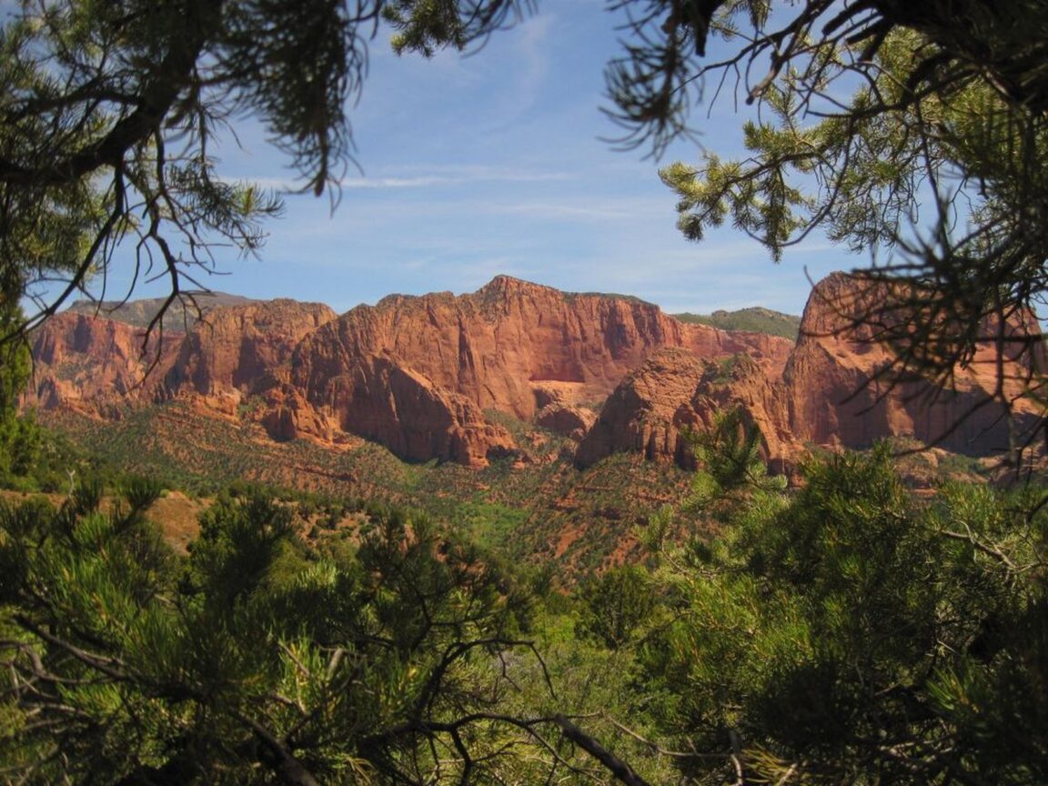
Stand at the Kolob Canyons Viewpoint and the difference explains itself. Instead of one great canyon, you face a row of finger canyons cut into the edge of the Colorado Plateau, parallel slots of red Navajo sandstone separated by forested ridges. The Park Service manages this as a distinct district of Zion, and it was protected separately first, as a national monument in 1937, before being folded into the park in 1956. The practical consequence for a visitor is a quieter, simpler operation: one entrance station, one short scenic road, a handful of trailheads, and none of the shuttle logistics that define a day in the main canyon.
The quiet is real but should not be oversold. The Taylor Creek trailhead parking is small, the scenic drive pullouts fill on fine autumn weekends, and the visitor center keeps shorter hours than its Zion Canyon counterpart, including a midday closure in the current schedule. What Kolob offers is not emptiness. It offers proportion: a half day or full day that fits in one hand, in a park famous for overwhelming people with options. Travellers building a wider Utah plan can pair it with our first timer guide format for national park districts approach of one anchor hike, one scenic drive and one viewpoint per day, which is exactly the rhythm Kolob rewards.
How should you drive the five mile Kolob Canyons Road?
The road is the district in miniature, and it should be driven slowly, uphill first, with stops saved mostly for the way down when the light has shifted. It climbs about 1,000 feet from the visitor center to the viewpoint, following the finger canyons as they deepen beside you. The numbered stops correspond to a brochure available at the visitor center, which is worth collecting because the geology here is legible: you are looking at the Hurricane Fault zone and the western edge of the Markagunt Plateau, and the pullouts are placed where that story reads best.
At the road end, the Timber Creek Overlook Trail runs about a mile round trip along a ridge to a small peak. The Park Service and park guides describe the payoff consistently: Timber Creek below, the Kolob Terrace to the east and the Pine Valley Mountains to the west. It is the right first walk of the day for anyone not hiking Taylor Creek, and the right last walk for everyone, because the viewpoint light improves as the afternoon goes on and the red rock takes on its deepest color in the hour before the visitor center closes. In winter the scenic drive can close with snow, and in October 2026 park reporting noted a closure beyond the South Fork trailhead after a rockfall, so the conditions check is not a formality here. Check the NPS alerts page on the morning of the visit, every time.
What makes the Taylor Creek Trail the hike to prioritize?
Taylor Creek is the complete Kolob walk in a single trail: a perennial stream, shaded groves, history and a geological finale. The Middle Fork trail runs about 5 miles round trip with modest climbing, crossing the creek repeatedly as the canyon narrows. Partway in stand two homestead cabins from the early 1930s, built by settlers who tried to farm this canyon, and they do more to explain the human scale of Kolob than any exhibit. The trail ends at the Double Arch Alcove, a huge water streaked recess in the sandstone where two arch forms stack above a seep fed grotto with hanging vegetation. It is not a true arch you can stand beneath in the usual sense, and knowing that in advance makes the place more interesting, not less: the alcove is what running water does to this rock given enough time, written at full scale.
Walk it in the morning. The trailhead sits just up the road from the visitor center, the canyon holds shade early, and the creek crossings are easier to pick through in flat morning light. Dogs are not permitted on the trail, day hiking needs no permit, and the creek crossings mean footwear that can get wet is a better choice than pristine boots in spring. Allow two and a half to three and a half hours at a sightseeing pace, longer if the cabins and the alcove get the attention they deserve. If you have a second hike in you, the La Verkin Creek Trail from Lee Pass is the district’s bigger commitment, about 14 miles round trip to Kolob Arch, one of the largest natural arches in the world by span, and it is better treated as a long day or an overnight with the required wilderness permit than squeezed into a first visit.
How does the Kolob Terrace Road fit into the same trip?
The Kolob Terrace is the connective tissue of this story, and the source of the most common planning mistake. Kolob Terrace Road is not reached from the Kolob Canyons entrance. It climbs from the town of Virgin, near the main canyon’s south entrance, up onto the high plateau between Zion Canyon and the Kolob Canyons district, passing the trailheads for the West Rim and the Subway route and reaching Lava Point, among the highest viewpoints in the park. It belongs in a Kolob themed trip as a separate half day, not as a continuation of the scenic drive, and the two roads do not connect for ordinary vehicles.
Handled that way, the terrace completes the picture the finger canyons begin. From Lava Point you look back across the plateau the canyons are cut into, and the whole northwest quadrant of the park reads as one system: high country, incised canyons, creek fed alcoves. The upper road is not maintained beyond a point in winter and closes with snow, so its season is shorter than the Kolob Canyons Road season. Pair the terrace morning with an afternoon in the main canyon, or give the Kolob district a full day and the terrace its own slot on the drive between Springdale and Cedar City. For another scenic drive planned with the same discipline, see our Chain of Craters Road guide, which applies the same stops, conditions and turnaround logic to a very different landscape.
Where should you base yourself for Kolob Canyons?
Cedar City is the natural base for a Kolob focused day: about 17 miles north of Exit 40, with the widest choice of lodging and food on this side of the park and an easy interstate approach. Springdale, at the main canyon entrance, works if Kolob is one day inside a longer Zion stay, with the understanding that the drive between the districts is about 40 miles and should be done in daylight. A few smaller communities along the interstate corridor offer simpler motels for road trippers crossing Utah. Whichever base you choose, the sequencing rule holds: visitor center first for conditions and the road brochure, Taylor Creek in the morning, the scenic drive pullouts and Timber Creek Overlook in the afternoon, and a same day check of NPS hours, because the Kolob Canyons Visitor Center currently closes for an hour at midday and a 5 p.m. finish is earlier than many summer visitors expect.
Frequently asked questions
Is Kolob Canyons included in the Zion entrance pass?
Yes. The standard Zion entrance pass, $35 per private vehicle for seven days, covers both the Kolob Canyons district and Zion Canyon. There is no separate fee and no timed entry reservation for Kolob Canyons. Current park fee reporting notes a $100 surcharge for non US resident visitors from 2026, waived for annual pass holders, so check the NPS fees page before you go.
Do you need the shuttle at Kolob Canyons?
No. Unlike Zion Canyon Scenic Drive, the Kolob Canyons Road is open to private vehicles year round, weather permitting. You drive the five mile scenic road yourself. Snow and rockfall can close sections, so check park alerts on the day.
How long is the Taylor Creek Trail?
About 5 miles round trip on the Middle Fork of Taylor Creek, ending at the Double Arch Alcove and passing two homestead cabins from the early 1930s. Allow roughly two and a half to three and a half hours. No permit is needed for the day hike, and dogs are not allowed on the trail.
What are the Kolob Canyons Visitor Center hours?
The National Park Service hours page, updated November 16, 2026, lists the Kolob Canyons Visitor Center as open 8 a.m. to 5 p.m., closed for an hour at midday. Hours change seasonally, so verify on nps.gov before your visit.
Can you drive from Kolob Canyons to the Kolob Terrace?
Not directly. The Kolob Terrace Road starts in the town of Virgin, near the main canyon, and climbs onto the plateau from there. Treat the terrace as a separate half day. Its upper section closes in winter and is not maintained beyond a certain point in snow.
When is the best time of year for Kolob Canyons?
Spring through autumn gives the most reliable road access and the best hiking conditions. The district sits higher than Zion Canyon, so it runs cooler in summer and holds snow earlier in winter. Autumn color in the canyon bottoms and spring runoff in Taylor Creek are the two seasonal highlights most often cited by the park and local guides.
Photo: The red finger canyons of the Kolob Canyons district framed by pine, Zion National Park. Photo: National Park Service, via nps.gov, the official site of Zion National Park.