 Lucas Meyer
Assateague’s horses get the postcards, but the island’s real depth starts where the day-use beach ends. This 37-mile barrier island, split between Maryland and Virginia with no road connection between its two entrances, holds two oceanside and four bayside backcountry camps reached only on foot or by paddle, frontcountry campgrounds that exist only on the Maryland side, kayak landings on two sheltered bays, and two separate horse herds managed under entirely different rules. Go beyond the pony viewing and Assateague becomes a small wilderness with a beach attached. Here is how the island actually divides, and how to use the quieter half of it.
Quick Facts
- The split: Assateague has two entrances with no vehicle access between them. The north entrance is at the end of Route 611, eight miles south of Ocean City, Maryland; the south entrance is at the end of Route 175, two miles east of Chincoteague, Virginia.
- Camping rule: All camping is in Maryland. The National Park Service states plainly that no camping is permitted in the Virginia district.
- Entrance pass: $25 per private vehicle for seven days, valid in both districts and at Chincoteague National Wildlife Refuge; the park annual pass is $45, per the National Park Service.
- Frontcountry camping: Oceanside and bayside sites are $40 per night, with reservations required from March 15 through November 15.
- Backcountry permit: $10 per person aged 16 and over, valid up to seven days, issued first come, first served at the Ranger Station in Maryland only.
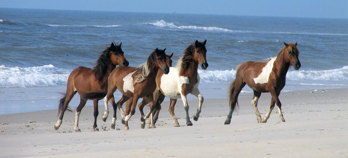
- Horse distance: Stay at least 40 feet, about one bus length, from wild horses at all times. Approaching, touching or feeding them is prohibited.
- Two herds: The National Park Service manages the Maryland herd as wildlife; the Chincoteague Volunteer Fire Company owns and manages the Virginia herd, which grazes on Chincoteague National Wildlife Refuge under a federal permit.
Why does the Maryland and Virginia split change everything?
Most first-time visitors assume Assateague is one park with one gate. It is closer to two parks sharing an island. The Maryland end, reached from Ocean City and Berlin, holds the national seashore campgrounds, the backcountry system, an adjacent state park and the free-roaming Maryland horse herd. The Virginia end is largely Chincoteague National Wildlife Refuge, managed by the US Fish and Wildlife Service, where the famous ponies are actually owned livestock grazing under permit, rounded up each July for the Pony Penning swim to Chincoteague Island that Marguerite Henry’s Misty of Chincoteague made famous. The herds are separated by a fence at the state line and never mix.
The practical consequences are sharp. You cannot drive from one end to the other on the island; the roughly 50 miles between the north and south ends takes about an hour and a quarter by road, back on the mainland. Pets are prohibited entirely in the Virginia portion, even inside your car, and there is no camping at that end, so a Virginia day is built around the refuge’s Wildlife Loop, the beach at Toms Cove and a bed in the town of Chincoteague. A Maryland stay is built around camping and the backcountry. Choose your end before you choose your activities, and if you want both, give them separate days rather than trying to thread them together. The park’s fees page confirms one mercy: a single entrance pass covers both districts.
What is the difference between oceanside and bayside camping?
The Maryland campgrounds split by water. Oceanside drive-in and walk-in sites sit behind the dunes on the Atlantic side: surf noise, sea breeze, sunrise over the ocean and a short walk to the swimming beach. Bayside drive-in sites sit on Sinepuxent Bay: calmer water, marsh views, sunset light, and direct access to crabbing, clamming and paddling. Both cost $40 per night with a picnic table and fire ring and no hookups, and both operate under the same booking reality the park service states bluntly: reservations are required from March 15 through November 15 and nearly all weekend reservations fill the day they become available, six months out.
Choose oceanside for beach days and storm-watching, bayside for boats and birds. Bayside campers should take the park’s insect warning seriously in summer; the marsh that makes the paddling good also breeds biting insects, and the park advises that bayside backcountry sites carry high concentrations of them from April through October. Screen tents, repellent and long tent stakes for sand and wind are on the park’s own packing advice for a reason. Group sites run $80 per night, and the two horse camp sites, available from October 16 through April 14, also cost $80. Full site details are on the park’s Maryland camping page. For a different barrier island where the camping and the ferry maths dominate the trip instead, see our Cumberland Island family guide.
How does backcountry camping on Assateague work?
The backcountry system is the island’s best-kept structure. Six sites, Little Levels and State Line on the oceanside and Tingles Island, Pine Tree, Green Run and Pope Bay on the bayside, are open to visitors who backpack or paddle in. From the Maryland Ranger Station the distances run from 2.5 to 13 miles. Every site is in Maryland, every permit must be bought at the Maryland Ranger Station, and permits are first come, first served with no advance reservations. A permit costs $10 per person for campers aged 16 and over and lasts up to seven days, on top of the vehicle entrance pass.
The rules define the experience. No fresh water exists at any backcountry site, and the park sets the minimum at a gallon per person per day, carried in. Pets are banned. Campers may not be ferried by any motorised boat or vehicle, including over-sand vehicles, so everything arrives under your own power. Check-in deadlines are tied to sunset and distance, running from two hours before sunset for the nearest sites to four hours for Green Run, State Line and Pope Bay from Maryland, and far earlier for anyone starting from Virginia. Sites close for set hunting dates each fall and winter and can close in spring and summer for nesting birds, so the park’s backcountry camping page, checked the week of your trip, is part of the permit process in practice. Oceanside sites sit in open inner dunes beside the over-sand vehicle zone; bayside sites sit in forest, with fire rings, picnic tables and chemical toilets, and Pope Bay is the exposed exception with limited shade.
Where do kayaks actually go in the water?
Paddling is a Maryland-side game centred on two bays. On Sinepuxent Bay, Old Ferry Landing is the park’s named kayak launch and crabbing spot, rebuilt with a raised bulkhead and new boardwalks, and the Bayside Drive area hosts the park’s rental operation for kayaks, canoes and paddleboards in season. From these landings the marsh creeks and coves behind the island open up: sheltered water, herons and egrets, and a view of the island that the beach never gives. Paddlers heading for the bayside backcountry sites park at Old Ferry Landing or the Bayside Picnic Area, as the park directs, and should check the marine forecast for the coastal waters between Fenwick Island and Chincoteague before launching, since outfitters will not rent during a small craft advisory and neither should you set out in one.
On the Virginia side, canoes and kayaks can be launched and beached at Toms Cove outside the lifeguarded beach sections, and Chincoteague town outfitters rent boats for the refuge channels and Chincoteague Bay. The split applies here too: a Virginia paddle is a day trip that ends at a Chincoteague bed, while a Maryland paddle can end at your own tent at a bayside site, which is the single best reason to camp bayside with a boat on the roof.
How should you actually watch the horses?
Beyond the ponies turns out to include watching the ponies properly. The park’s rule is a legal minimum of 40 feet, one bus length, and the park service is explicit that even that can be too close depending on circumstances. If a horse approaches you, the obligation is yours: back off, return to your vehicle, keep windows up and never open trunks or coolers near horses. Feeding and petting are prohibited and citable, and the reasons are not bureaucratic. Horses conditioned to beg become road hazards and biters; the park records visitor bites and kicks every year and an average of one horse a year killed on its roads.
The Maryland herd is managed as wildlife, with its size held near a goal range of 80 to 100 animals through a long-running fertility control programme; the March 2026 census counted 83 horses. The Virginia herd, capped at roughly 150 adults under its refuge permit, is the one swum across the channel on the last Wednesday of July. Watching either herd well means distance, patience and binoculars, ideally in the marsh along the Maryland bay side or from the refuge’s Wildlife Loop in Virginia, rather than a roadside cluster. Give the island a second day beyond the beach and this is the Assateague that stays with you: a dawn paddle past a bayside camp, horses grazing a marsh at a proper distance, and nobody else around. If island camping in the mid-Atlantic whets your appetite for the boat-access version further south, our Biscayne weekend guide to Boca Chita Key covers the Florida counterpart.
Fees, permit rules, campsite details and herd figures checked against the National Park Service on November 20, 2026. Backcountry closures for hunting and nesting change by date; confirm site status at the Maryland Ranger Station before setting out.