 Omar Haddad
The quietest version of Sedona is organised around water, shade and darkness rather than vortex tours: Oak Creek’s swimming holes in a deliberate order from the busy canyon mouth to the calm pools downstream, trails on the west side of town that the shuttle crowds never reach, and pullouts where the red rock sky goes properly dark after sunset. It works only if the parking rules are understood first, because Sedona runs three separate fee systems within a few miles of each other, and the pass that covers the trailheads does not cover the creek sites most swimmers are heading for. Get that one distinction right, and a paced wellness day here, creek in the morning, quiet trail in the afternoon, dark sky at night, is straightforward.
Quick Facts
- The pass rule: If you leave your vehicle at a designated fee site in the Red Rock Ranger District of Coconino National Forest, a Red Rock Pass or a federal recreation lands pass must be displayed in the vehicle, per the Forest Service.
- The exception that catches swimmers: Neither pass grants access to concessionaire managed fee sites or state parks. The creek swimming and picnic sites run by concessionaires, and Slide Rock State Park, charge their own fees.
- The prices: The Forest Service Red Rock Recreation Guide lists the Red Rock Pass at 5 dollars a day, 15 dollars a week and 20 dollars a year, per vehicle, bought at fee site machines, the Red Rock Ranger District Visitor Center or on Recreation.gov.
- The creek order: Slide Rock and Grasshopper Point for early, confident swimmers; Crescent Moon and Red Rock Crossing for the calm, classic Cathedral Rock view and picnic shade; the West Fork of Oak Creek for shade and walking rather than swimming.
- The quiet trails: Fay Canyon, the Templeton Trail along the creek, and the Baldwin Trail loop on the south side see a fraction of the Cathedral Rock and Devil’s Bridge traffic.
- The dark sky: Sedona’s developed core glows; the pullouts on the Red Rock Loop Road and the Dry Creek Road corridor, away from streetlights and inside national forest land, are where the Milky Way shows.
- Facts checked: 20 November 2026, against the Coconino National Forest pages and Red Rock Recreation Guide on fs.usda.gov.
Which pass do you actually need, and where does it not work?
Start with the Forest Service’s own wording. The Coconino National Forest passes page on fs.usda.gov explains that both the Red Rock Pass and the Coconino Pass cover fees at many recreation sites in the Sedona area, and that the America the Beautiful interagency pass is also sold and accepted across federal recreation land. The forest’s Red Rock Recreation Guide, also published on fs.usda.gov, states the operating rule: if you leave your vehicle while recreating at one of the fee sites, you must display a Red Rock Pass or a federal recreation lands pass in the vehicle, passes cannot be transferred between vehicles, and, in the sentence the whole day turns on, neither pass grants access to state parks or concessionaire managed fee sites.
That sentence divides Sedona in two. The standard trailheads, Cathedral Rock, Bell Rock, Boynton Canyon, Fay Canyon and the rest of the signed fee sites, sit in the first system: one pass per vehicle, bought from the credit card vending machines at the sites, from the Red Rock Ranger District Visitor Center on State Route 179, from local vendors, or online through Recreation.gov, where the licence plate number becomes the pass. The famous creek sites sit in the second system. Crescent Moon, Grasshopper Point and the West Fork trailhead at Call of the Canyon are concessionaire managed and take their own per vehicle day fee at the gate, and Slide Rock is an Arizona state park with its own entry fee. A traveller who buys a Red Rock Pass expecting it to open the swimming holes has bought the right pass for the afternoon hike and the wrong one for the morning swim, so budget for both systems and treat them as separate line items.
What is the right order for Oak Creek’s swimming holes?
Work downstream in time as well as geography, busiest first while it is still early. Slide Rock State Park, up the canyon on State Route 89A, is the headline swim: a natural sandstone chute in Oak Creek inside a historic apple orchard. It is also the site that fills first, charges a state park vehicle fee that neither forest pass touches, and rewards an arrival near opening far more than any other stop on this list. Go there first or not at all.
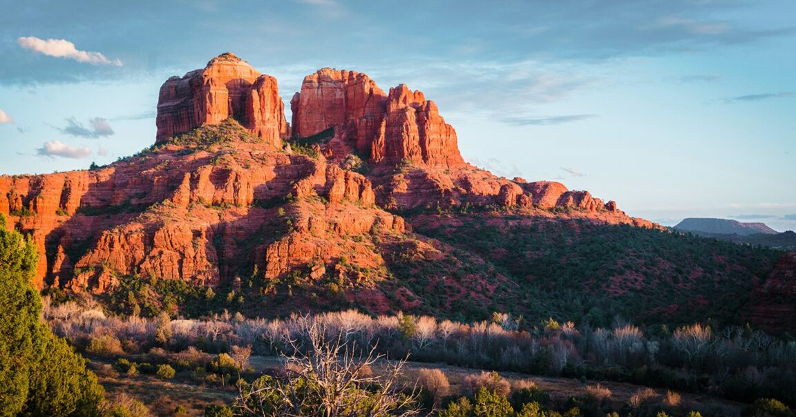
Grasshopper Point, just below the canyon mouth, is the local alternative: a concessionaire day use site with deep pools under the canyon walls, cliff edges that draw jumpers, and the same separate gate fee logic as the other creek concessions. Crescent Moon, reached by the Red Rock Loop Road, is the calm end of the spectrum and the right main swim of a wellness day: a concessionaire picnic site on a broad bend of the creek, with the postcard view of Cathedral Rock across the meadow, shallow edges for wading, deeper pools along the rock, and cottonwood shade for the hours between swims. End the water part of the day on the Templeton Trail, which leaves the Crescent Moon area and follows the creek below Cathedral Rock to quieter pools and slickrock ledges at Buddha Beach, where the swimming is informal, the rock is warm and the crowds thin to almost nothing on a weekday.
Two creek rules apply everywhere on this list. Oak Creek runs cold even in summer and its sandstone is polished slick when wet, so water shoes earn their space in the bag; and creek conditions change with storms upstream, so any sign of rising or discoloured water ends the swim, a desert rule with no exceptions. For a different desert water day built on the same caution, see our guide to the Dead Sea on the Jordan side.
Which trails stay quiet when the famous ones fill?
Fay Canyon first. Its trailhead sits in the same west Sedona fee site cluster as the celebrated Boynton Canyon, takes a Red Rock Pass, and then walks into a short, shaded box canyon that most visitors turn back from too early, before the natural arch viewpoint and the canyon end ruins viewpoint. It is flat, calm and finished by the time the Devil’s Bridge line has moved twice.
On the south side, the Baldwin Trail and the Templeton Trail combine into the quiet creek level loop of the area, walking distance from Crescent Moon, with Cathedral Rock overhead the whole way and almost none of the summit trail traffic, because the walkers on it are looking at the creek rather than queuing for the saddle photograph. In the Village of Oak Creek, the Bell Rock Pathway tells the same story in reverse: the formation is famous, the pathway itself, walked south toward Courthouse Butte in the late afternoon, empties out within ten minutes of the trailhead. Quiet in Sedona is rarely about secret places. It is about taking the level trail beside the famous climb, at the hour the climb is busiest.
Where do you go for dark skies and stillness after sunset?
Sedona markets itself on dark skies, and the town has genuinely worked to limit light, but the honest version is that the developed core along State Route 89A still glows. The dark is a short drive out, onto national forest land where the only lights are the ones visitors bring. The pullouts and fee sites along the Red Rock Loop Road, with Cathedral Rock silhouetted to the north, and the Dry Creek Road corridor west of town, toward the Fay and Boynton trailheads, are the reliable near town choices: park legally, let eyes adjust for twenty minutes, and the Milky Way core shows in the summer months over the red rock rim.
Bring the discipline that makes it a wellness practice rather than a photo stop. Red light only, phones away, an hour rather than ten minutes, and a plan to be parked before full dark rather than driving forest roads in it. Travellers building a wider American parks trip around nights like this should also read our explainer on US national park reservations in 2026, because the same federal pass that covers Sedona’s trailheads is the one that anchors the bigger itinerary.
How does a paced wellness day in Sedona actually run?
Creek early, trail late, sky last, with the heat of the day deliberately spent in shade and water rather than on exposed rock. Arrive at the chosen creek site near its opening, swim and sit until late morning, then take the long lunch and the slow hours in the shade at Crescent Moon or in town, off the trails entirely. Walk Fay Canyon or the Baldwin and Templeton loop in the last three hours of light, when the rock turns the colour the brochures promise and the fee site lots have emptied. Eat, then drive the short leg out to a Loop Road or Dry Creek pullout for the dark hour. Nothing in that day requires a tour, a guide or a vortex, and every part of it is better for the order it runs in.
Frequently asked questions
Does the America the Beautiful pass replace the Red Rock Pass?
At the standard Forest Service fee sites, yes: the Coconino National Forest accepts a federal recreation lands pass in place of the Red Rock Pass, displayed in the vehicle. At concessionaire sites and at Slide Rock State Park it does not apply, because neither pass grants access to those sites; they charge their own fees.
Can I swim in Oak Creek for free?
The developed swim sites on this route, Slide Rock, Grasshopper Point, Crescent Moon and West Fork, are all fee sites under one system or another. Informal creek access exists along the Templeton Trail and at Buddha Beach, reached on foot from the Crescent Moon fee area. Wherever you enter, treat the creek as cold, slick and storm sensitive.
What is the quietest famous name trail in Sedona?
Fay Canyon, for the effort involved: a flat, shaded canyon walk minutes from the busiest trailheads in west Sedona, with a fraction of their traffic. The Baldwin and Templeton loop below Cathedral Rock is the quietest way to spend time with the most famous formation in town.
When is the best season for this version of Sedona?
Late spring and early autumn balance the whole day: the creek is swimmable, the trails are walkable in the afternoon rather than only at dawn, and the nights are long and clear enough for the dark sky hour without winter cold on the pullouts.
Pass and fee facts checked 20 November 2026 against fs.usda.gov, the Coconino National Forest passes page and the Red Rock Recreation Guide. Concessionaire and state park fees are set by their operators and change separately; check the gate price on the day.