 River Callahan
Most Sequoia trips go wrong in predictable places: a long vehicle committed to the hairpins of the Generals Highway below Giant Forest, a picnic left visible in a car where bears and marmots work, or the General Sherman car park attempted at noon when the crowd peaks. None of these mistakes requires bad luck, only a first visit planned from a map instead of from the park’s own rules. The entrance fee is $35 per vehicle for 7 days and covers Kings Canyon too, the park takes cards only at its entrance stations, and the fixes below, on roads, food storage and timing, are the difference between a strained day and the one the Giant Forest deserves.
Quick Facts
- Park: Sequoia National Park, California, managed as one unit with Kings Canyon National Park; one pass covers both
- Entrance fee: $35 per private vehicle, $30 per motorcycle, $20 per person on foot or by bike, each for 7 days, per the National Park Service fees page checked on November 19, 2026
- Extra 2026 fee: Non US residents aged 16 and over pay an additional $100 per person unless entering on an annual pass, and entrance stations are cashless
- Road advisory: Vehicles longer than 24 feet are not advised between the Foothills Visitor Center and Potwisha Campground, or longer than 22 feet from Potwisha to the Giant Forest Museum; single vehicles over 40 feet are prohibited on that stretch
- Hard restrictions: Vehicles over 22 feet and anything towing are prohibited on the Moro Rock and Crescent Meadow Road and on Crystal Cave Road
- General Sherman Tree: 274.9 feet tall, 36.5 feet maximum base diameter, about 52,500 cubic feet of trunk, the largest living tree by volume
- Moro Rock: A stairway of more than 350 steps climbing 300 feet to a 6,725 foot summit
- Winter rule: The Generals Highway between Lodgepole and Grant Grove is unplowed and often closed from the Friday after January 1 to the third Friday in March
- Prices checked: November 19, 2026, against National Park Service sources
Mistake one: driving the wrong vehicle up the Generals Highway?
The single most consequential Sequoia error happens before the big trees appear. The Generals Highway from the Ash Mountain entrance, the continuation of Highway 198 from Three Rivers, climbs about 5,000 feet through hairpin turns built in the early 1920s, and the National Park Service publishes exact length guidance for it on its oversized vehicle page. Vehicles longer than 24 feet are not advised between the Foothills Visitor Center and Potwisha Campground. Vehicles longer than 22 feet are not advised from Potwisha Campground to the Giant Forest Museum. Single vehicles longer than 40 feet are prohibited outright on that second stretch. These are advisories with physics behind them: long vehicles cross the double yellow line on the switchbacks and meet oncoming traffic where the road has no width to give. The fix is routing, not courage. Longer vehicles, RVs and anything towing should enter from the north on Highway 180 from Fresno through the Big Stump entrance and Grant Grove, and approach Giant Forest from Lodgepole, where the road is wider and straighter. Two side roads carry hard prohibitions rather than advice: the Moro Rock and Crescent Meadow Road bans single vehicles over 22 feet and all towing units, and Crystal Cave Road bans vehicles over 22 feet. In summer the Moro Rock road also closes to private cars at busy times while the free shuttle runs, which is the park quietly telling drivers the correct answer.
Mistake two: leaving food where bears and marmots can work on it?
Sequoia’s wildlife treats a badly stored picnic as a standing invitation, and the park’s rules exist because the animals learned faster than the visitors. Black bears in Giant Forest and Lodgepole can open car doors and recognise coolers on sight, so the rule is absolute: food, drinks, toiletries and anything scented go in the metal food storage boxes provided at car parks and campgrounds, never left visible in a vehicle, and never left in a car overnight. The less famous culprits are yellow bellied marmots, which in late spring and early summer, most notoriously around Mineral King, climb into engine bays and chew radiator hoses and wiring, a habit the park links to a taste for coolant and salt. The park’s bear and food storage guidance is the document to read before packing, not after the first warning ticket. Day hikers make the softer version of the same mistake at trailheads: a boot full of snacks, a rubbish bag tied to a bumper, a child’s juice box in an open rucksack pocket at the Sherman Tree. Store it, carry it out, or watch a ranger explain the fine. None of this is abstract. A fed bear in these parks is a bear whose behaviour escalates until it is removed, and a marmot disabled car at Mineral King is a tow truck problem at the end of a long mountain road.
Mistake three: timing the Sherman Tree and Moro Rock for the worst hour?
The General Sherman Tree is the largest living tree on earth by volume, 274.9 feet tall with a trunk of about 52,500 cubic feet, and between late morning and mid afternoon in season its car parks fill and the main trail becomes a slow procession. The trail from the Wolverton Road car park descends about half a mile to the tree, which means the climb back is uphill at altitude, a fact that surprises visitors who budgeted their energy for a stroll. The timing fix costs nothing: walk down before 9 in the morning or after 4 in the afternoon, when the light is better, the fence line is clear and the Congress Trail, which continues past Sherman into a quiet grove of giant sequoias, can be added as a peaceful 2 mile loop. Moro Rock makes the same point vertically. Its stairway climbs more than 350 steps and 300 feet in about a quarter of a mile to a narrow summit at 6,725 feet with handrails and serious drop offs. It is a magnificent half hour early or late in the day and a hot, crowded queue at noon, and it should be skipped entirely in lightning, when the exposed granite is the worst place in the park. Visitors building a wider Sierra big tree route can compare the crowds here with the quieter grove strategy in our Mariposa Grove guide, and the cave tour timing traps in our Great Basin mistakes guide follow the same book early logic.
Mistake four: assuming the two parks connect in every season?
Sequoia and Kings Canyon are sold as one unit, one $35 pass covers both, and the Generals Highway links Giant Forest to Grant Grove in about an hour of driving in good conditions. The winter asterisk is large. The park states that the section between Lodgepole and Grant Grove is unplowed and often closed from the Friday after January 1 to the third Friday in March, and snow can close it at other times too; the detour between the parks then runs outside the boundary on Highway 245. Tire chains are a second winter trap: California chain control applies inside the parks, rentals rarely include chains, and the 24 hour road conditions line, (559) 565 3341, is the source to check on the morning of any winter drive rather than a forecast app. Summer has its own version of the trap. Crystal Cave, the parks’ marble cave, is reached by its own narrow road with the 22 foot prohibition, and its tours are ticketed separately and sell out, so a party that drives the cave road on spec has spent an hour to read a sold out sign. Book cave tickets in advance, check the road page the same day, and treat the two parks as one trip with a seasonal hinge in the middle, not as a single loop that always turns.
Mistake five: underestimating altitude, distance and the cashless gate?
The Giant Forest sits between roughly 5,000 and 7,000 feet, and first day headaches, breathlessness on the Sherman climb and poor sleep are altitude doing ordinary work. The honest pacing is a gentle first day, water carried on every trail, and the strenuous climbs, Moro Rock included, left for day two. Distances deceive in the same direction: the park’s own trip planner allows about an hour for the 16 miles from the Foothills Visitor Center to Giant Forest, and visitors who schedule Three Rivers breakfast, Sherman, Moro Rock, Crystal Cave and Grant Grove into one day have scheduled a windscreen tour. Finally, the gate itself: entrance stations at Ash Mountain and Big Stump are credit and debit only, and the park does not accept cash there. Visitors who prefer cash can buy a pass in advance at the Sequoia Parks Conservancy stores in the Foothills Visitor Center or the Kings Canyon Visitor Center, or buy the pass on Recreation.gov before travelling, per the park’s fees page. Non US residents should also budget the 2026 surcharge honestly: $100 per person aged 16 and over on top of the vehicle fee unless an annual pass is used, which makes the annual pass the rational purchase for most international parties visiting more than one park.
Frequently Asked Questions
Can an RV drive the Generals Highway to Giant Forest?
Not sensibly from the south. Vehicles longer than 22 feet are not advised between Potwisha Campground and the Giant Forest Museum, longer than 24 feet are not advised below Potwisha, and single vehicles over 40 feet are prohibited on the upper stretch. Longer vehicles should enter on Highway 180 from Fresno and approach Giant Forest from the north.
How much does Sequoia cost to enter in 2026?
A private vehicle pass costs $35 and is valid for 7 days in both Sequoia and Kings Canyon. Motorcycles pay $30 and visitors on foot or by bike pay $20 per person. Non US residents aged 16 and over pay an additional $100 per person unless admitted on an annual pass, and entrance stations do not accept cash.
Why do marmots matter to a Sequoia trip?
Yellow bellied marmots, most famously around Mineral King in late spring and early summer, climb into engine bays and chew hoses and wiring. Combined with black bears that open cars for visible food, they are the reason the park’s food storage rules cover vehicles as strictly as campsites.
When is the General Sherman Tree least crowded?
Before 9 in the morning and after 4 in the afternoon. The main trail is about half a mile downhill from the Wolverton Road car park to the tree, so the return is an uphill walk at altitude; early and late visits are cooler, quieter and better lit.
Is the road between Sequoia and Kings Canyon open in winter?
Often not. The Generals Highway between Lodgepole and Grant Grove is unplowed and often closed from the Friday after January 1 to the third Friday in March, with Highway 245 outside the parks as the detour. Check the park road line, (559) 565 3341, on the day of travel.
Can any vehicle use the Moro Rock road?
No. Single vehicles longer than 22 feet and all vehicles towing are prohibited on the Moro Rock and Crescent Meadow Road, and in summer the road closes to private cars at busy times while the free shuttle serves Moro Rock and Crescent Meadow.
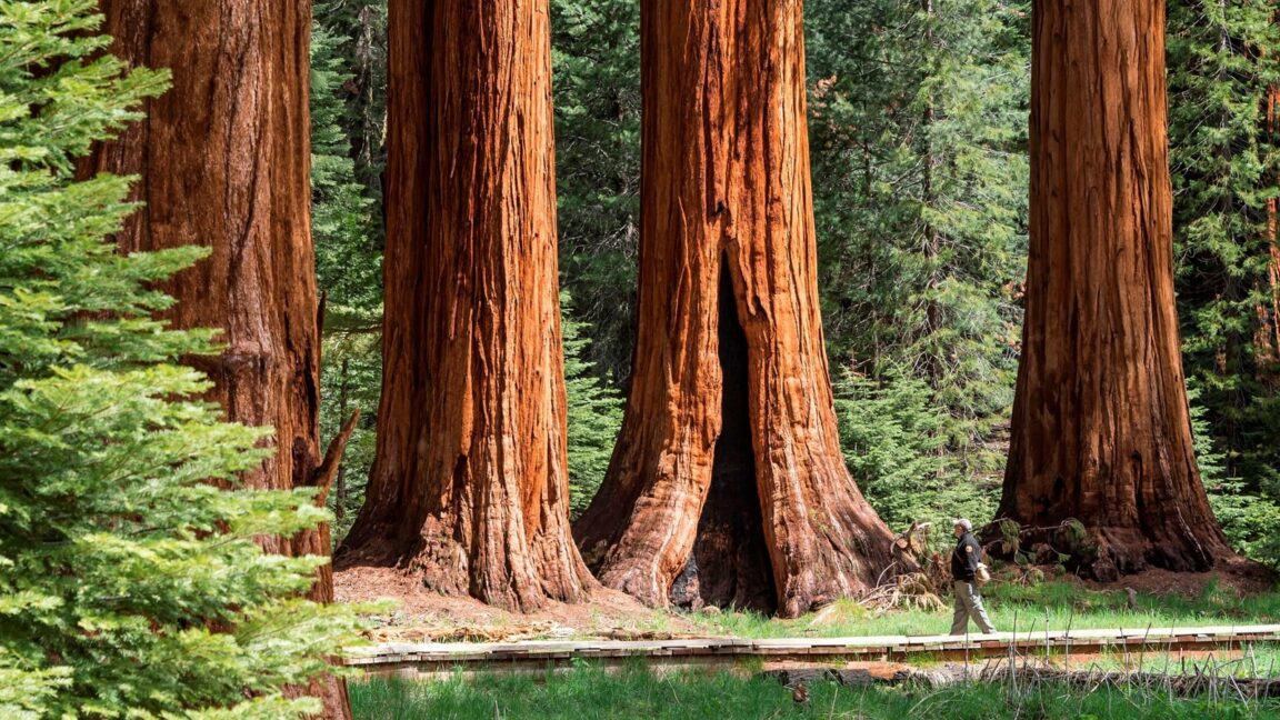
Featured image: Giant sequoia trunks in Crescent Meadow, Giant Forest, with a ranger on the boardwalk giving scale. Photo from the National Park Service official site (nps.gov), National Park Service, US Government work, used with credit.