 Priya Nair
Beyond the Scenic Drive, Capitol Reef becomes a different park: Cathedral Valley in the north is a full day on unpaved roads that starts with a ford of the Fremont River and ends among freestanding sandstone monoliths, the Burr Trail in the south climbs 800 feet of switchbacks in half a mile, and the Fruita orchards back in the valley still let visitors pick ripe fruit in season and pay at a self-pay station. None of it needs a reservation, but all of it needs the right vehicle, a same-day road check at the visitor center, and more time than the map suggests. This guide is for the repeat visitor who has already driven the paved 7.9 miles and wants the park’s second layer, in the order that works.
Quick Facts
Where: Capitol Reef National Park, south central Utah. Cathedral Valley branches off Utah Highway 24 east of the visitor center; the Burr Trail runs from Boulder on Highway 12 to the Notom-Bullfrog Road.
Scenic Drive fee: $20 per private vehicle, $15 per motorcycle, $10 per person on foot or by bike, valid 7 days, per the National Park Service. Highway 24 through the park carries no fee.
Cathedral Valley: A roughly 58 mile unpaved loop. High-clearance vehicles are required at best, and high-clearance four-wheel drive may be needed for the Fremont River ford.
Burr Trail: Paved from Boulder to the park’s west boundary, then 8.5 miles of graded dirt inside the park, including switchbacks the Park Service says are not suitable for RVs or vehicles towing trailers.
Road conditions line: (435) 425-3791, press 1 for visitor information and 4 for road conditions. Check on the day, every time.
Fruita orchards: About 2,000 historic trees. Picking only in orchards posted as open; fruit eaten in the orchard is free, fruit taken away is paid for at a self-pay station.
Prices checked: 21 November 2026, against the National Park Service.
What changes once you leave the pavement?
The Scenic Drive is a there-and-back paved road with maintained dirt spurs into Grand Wash and Capitol Gorge. Beyond it, the park’s three districts run on their own rules. The Waterpocket Fold, the nearly 100 mile wrinkle in the earth’s crust that defines Capitol Reef, keeps unfolding south along the Notom-Bullfrog Road and west up the Burr Trail. Cathedral Valley, in the park’s remote north, is reached only on unpaved roads off Highway 24. Distances stretch, mobile signal fades, and weather that barely registers in Fruita can close a dirt road outright. The Park Service advises checking with the visitor center before driving any of the park’s dirt roads, and that advice is the organising principle of everything below.
For the first-timer version of this park, start with our Capitol Reef guide to Fruita, Hickman Bridge and the Scenic Drive. This article assumes that day is done and spends its time where the pavement ends.
How do you drive the Cathedral Valley loop?
Start at the river, not at the temples. The Park Service encourages anyone driving the full loop to begin at the Fremont River ford, on the Hartnet Road 11.7 miles east of the visitor center, precisely so you learn whether you can make the crossing while retreat is still easy. The ford comes soon after leaving Highway 24 and may require a high-clearance or high-clearance four-wheel-drive vehicle, depending on the river’s depth that week. If the water is too high or your vehicle is wrong, the day is not lost, but the loop is: turn around and use the Cathedral Road entrance instead.
From the ford, the Hartnet Road runs 27.8 miles to its junction with the Cathedral Road, across the Blue Flats and the edge of the South Desert, with the country rising toward Thousand Lake Mountain at the loop’s northern end. The Cathedral Road, the loop’s eastern side, begins 18.5 miles east of the visitor center and reaches the Temples of the Sun and Moon 17.1 miles up the road in Lower Cathedral Valley. These massive Entrada sandstone monoliths rise straight from the desert floor, and further north in Upper Cathedral Valley the formations turn to spire-like columns. Allow the full day the Park Service suggests. Cathedral Valley roads require high-clearance vehicles even in good conditions, conditions vary widely with recent weather, and there are no services once you leave the highway.
What should you carry into Cathedral Valley?
Carry the day with you: a full tank before leaving Highway 24, more water than the drive seems to warrant, food, a paper map or an offline download, and a spare tyre you have actually checked. Tell someone your plan and your return time. If rain is forecast anywhere over the Fold, postpone. Unpaved roads here can become impassable quickly, and a loop that starts as graded dirt can end as a long wait for the ground to dry.
What is the Burr Trail actually like to drive?
The Burr Trail began as a cattle trail blazed by stockman John Atlantic Burr, and it still reads as a working route rather than a scenic ornament. From Boulder on Highway 12 the road is paved to Capitol Reef’s west boundary, crossing the Circle Cliffs country, Long Canyon and The Gulch. Inside the park it becomes a graded dirt road for 8.5 miles, and that stretch holds the drive’s famous moment: switchbacks rising some 800 feet in only half a mile. The Park Service is blunt that these switchbacks are not considered suitable for RVs or vehicles towing trailers, and the descent deserves the same respect as the climb.
East of the switchbacks, the Burr Trail meets the Notom-Bullfrog Road, which runs south along the eastern side of the Waterpocket Fold to Bullfrog and Glen Canyon National Recreation Area. Its first 15 miles south of Highway 24 are paved before it too becomes maintained dirt, with access to backcountry trailheads such as Lower Muley Twist and Halls Creek Narrows. Driven together, Burr Trail and Notom-Bullfrog make the Loop the Fold journey the Park Service describes, a long arc around the reef that pairs naturally with a base in Boulder or Torrey rather than a rushed out-and-back from Fruita. Travellers building a wider southern Utah loop can pair it with our Kanab base guide to the Wave lottery and Coral Pink Sand Dunes and the Zion where-to-stay guide for Springdale and the east side.
When do the Fruita orchards open for picking?
Back in the valley, the Fruita orchards are the gentle end of a beyond-the-drive trip, and their rules are specific. The orchards along the Fremont River and Sulphur Creek are remnants of the pioneer community of Fruita, settled in 1880, and today hold approximately 2,000 trees, including cherry, apricot, peach, pear, apple, plum, mulberry, quince, almond and pecan. The Park Service maintains them year round as part of the Fruita Rural Historic District, listed on the National Register of Historic Places.
Visitors are welcome to walk through any unlocked orchard at any time. Picking is different: fruit may not be harvested and taken from an orchard until that orchard is posted as open for picking, so check at the visitor center on the day. In an open orchard, handheld fruit pickers and ladders are provided, ripe fruit may be sampled in the orchard at no charge, and fruit you take away must be paid for at the self-pay station, scale and price sign near the entrance. The Park Service’s typical harvest windows, which vary widely by year, run from apricots in late June to mid July, peaches from late July to early September, pears from early August to early September, and apples from mid August to mid October. In late November the honest expectation is a quiet, leafless orchard walk rather than a harvest, which is its own pleasure after days of desert driving. For current availability in season, the park’s fruit hotline is (435) 425-3791, option 1, then option 5.
How should you sequence a beyond-the-drive trip?
Give each backroad its own day. Day one belongs to Cathedral Valley, started early at the river ford with a full tank and a visitor center road check, because the loop punishes a late start. Day two belongs to the Burr Trail and the Notom-Bullfrog Road, ideally driven as a through route toward Boulder or Bullfrog rather than doubled back. Keep Fruita, its orchards, the schoolhouse and the Gifford House for the arrival or departure day, when a short walk and a shaded picnic area are worth more than another hour of dirt road. If weather closes the backroads, the paved Scenic Drive and the Highway 24 corridor still deliver a full park day, and the backroads will keep.
Frequently asked questions
Do I need four-wheel drive for Cathedral Valley?
At best, the Park Service says high-clearance vehicles are recommended on the Hartnet Road and required in practice across the loop, and the Fremont River ford may require high-clearance four-wheel drive. Conditions vary widely with recent weather, so check at the visitor center before setting out and be ready to turn back at the ford.
How long does the Cathedral Valley loop take?
Plan a full day. The loop is roughly 58 miles of unpaved road, the Park Service says Cathedral Valley takes about a day to explore fully, and the Temples of the Sun and Moon alone sit 17.1 miles up the Cathedral Road from Highway 24.
Can RVs drive the Burr Trail switchbacks?
No. The Park Service states the switchbacks, which rise about 800 feet in half a mile on the 8.5 mile dirt stretch inside the park, are not considered suitable for RVs or vehicles towing trailers.
Is fruit picking at Fruita free?
Fruit eaten inside an orchard posted as open for picking costs nothing. Fruit you carry out must be weighed and paid for at the self-pay station near that orchard’s entrance. Orchards open for picking change through the season, so ask at the visitor center on the day.
What does it cost to enter Capitol Reef?
Highway 24 through the park is free. The Scenic Drive charges $20 per private vehicle, $15 per motorcycle or $10 per person on foot or by bike, valid 7 days, and America the Beautiful passes are accepted. Prices checked against the National Park Service on 21 November 2026.
Where do I check dirt road conditions?
At the visitor center before you drive any dirt road, as the Park Service advises, or on the park’s recorded line at (435) 425-3791, pressing 4 for road conditions. Conditions on the Hartnet and Cathedral roads vary widely with recent weather.
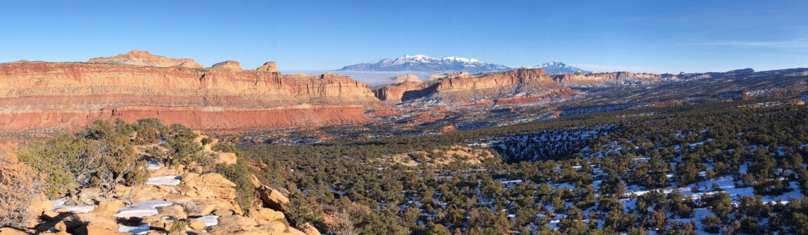
Featured image: Capitol Reef’s red cliffs and juniper country under the snow-capped Henry Mountains, Capitol Reef National Park. Photo: National Park Service (NPS Photo), via nps.gov, the park’s own official site. Prices and road details verified against the National Park Service on 21 November 2026.