 Lucas Meyer
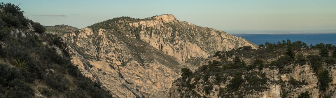
Guadalupe Mountains National Park is a hiker’s park built around one rule: there is no water. The range rises more than 3,000 feet out of the Chihuahuan Desert in West Texas and holds Guadalupe Peak, at 8,751 feet the highest point in Texas, the 1,000-foot limestone cliff of El Capitan, and McKittrick Canyon, where bigtooth maples turn red and orange each autumn along a desert stream. The National Park Service is blunt about the backcountry: there are no water sources in it, and every overnight route starts with a full carry of one gallon per person per day. Plan around that fact and the park opens up beautifully, more than 80 miles of trails through a 260-million-year-old fossil reef, ten backcountry campgrounds, and skies dark enough to read as a destination in themselves. Ignore it, and the same trails become the park’s most common rescue story.
Quick Facts
- The park: 86,416 acres in West Texas, just south of the New Mexico line on US Highway 62/180. Authorised by Congress in 1966 and formally established in 1972, per the National Park Service.
- The summit: Guadalupe Peak, 8,751 feet above sea level, the highest point in Texas. The Guadalupe Peak Trail is a strenuous round trip of about 8.4 miles with roughly 3,000 feet of climbing, listed by the NPS at 6 to 8 hours.
- The entrance fee: $10 per person aged 16 and over, valid for 1 to 7 consecutive days. The park annual pass is $35. America the Beautiful passes are accepted. Pay at Pine Springs Visitor Center, open daily 8:00am to 4:00pm, or at trailhead self-pay stations.
- The water rule: No water exists in the backcountry. NPS guidance is one gallon per person per day, about 8 pounds per gallon, carried from the trailhead. Water is available at Pine Springs Visitor Center and Campground, the McKittrick Canyon Contact Station and Dog Canyon.
- Overnight permits: All overnight wilderness trips require a wilderness use permit, arranged through the Pine Springs Visitor Center. McKittrick Canyon is day use only.
- Fall colour: McKittrick Canyon’s bigtooth maples usually peak in the last week of October and the first week of November. The canyon is gated, open during posted daytime hours, and the small parking lot fills on autumn weekends.
- The geology: The Guadalupes are the exposed edge of Capitan Reef, a roughly 400-mile, U-shaped Permian fossil reef complex, among the finest preserved ancient reef systems in the world.
An ancient reef standing in the desert
Start with the strangeness of the place. The pale limestone that forms El Capitan’s cliff and Guadalupe Peak’s summit pyramid is a reef, built by sponges, algae and marine organisms in a tropical sea during the Permian period, 260 to 270 million years ago. The National Park Service overview of the park describes the Capitan Reef complex as a mostly buried, roughly 400-mile U around the Delaware Basin, with its longest exposed stretch, 12 miles of it inside the park, running northeast from the Guadalupes toward Carlsbad. Fossil-bearing strata are found throughout the park, along with three internationally significant geological stratotype sections. Practically, this means the hiking is on reef rock: sharp, pale, waterless limestone that holds almost no soil on its ridges, which is why the range can stand 3,000 feet above the desert floor with so little growing on its upper slopes, and why a summit day here feels closer to the high desert of the Basin and Range than to any other Texas landscape.
Guadalupe Peak: the top of Texas
The signature hike climbs from the Pine Springs Trailhead, beside the main visitor center on US 62/180. The trail gains roughly 3,000 feet over about 4.2 miles to the summit, switching from desert scrub through pinyon pine and Douglas fir as it climbs, with El Capitan filling the view south for much of the upper mountain. A stainless steel pyramid marks the top, installed to commemorate the centennial of the Butterfield Overland Mail route, which passed the mountain’s foot in the 1850s. The NPS rates the hike strenuous and lists 6 to 8 hours; fit hikers move faster, but wind is the variable that decides days here. The summit ridge is exposed, the peak is cooler and markedly windier than Pine Springs, and gusts strong enough to turn hikers around are a regular feature rather than an exception. Carry the full gallon even for the day hike in warm months, start at first light in summer, and treat the descent on loose reef rock with the same respect as the climb: trekking poles earn their weight on the way down. A summit is also the natural pairing with the desert packing logic in Packing for a Desert National Parks Road Trip, since the water and layer rules there were written for exactly this climate.
McKittrick Canyon: maples in the desert
Seven miles northeast of Pine Springs, a gated road leads to the park’s other famous trailhead. McKittrick Canyon shelters a perennial stream, one of the very few in this desert range, and along it grows a relict woodland of bigtooth maple, oak and walnut left from a cooler, wetter age. In late October and early November the maples turn, and a desert canyon in West Texas briefly looks like New England. The canyon is day use only, the gate locks at the posted closing time, and the contact station at its mouth has water and restrooms. The main trail runs up the canyon past the stone Wallace Pratt Lodge, built in the 1930s by the petroleum geologist who bought land here in the 1920s, fell for the canyon, and in 1959 donated his property to the National Park Service, the gift around which the park eventually formed. Beyond the lodge the trail continues toward the Grotto and Hunter Line Cabin, and a steep branch climbs to McKittrick Ridge for backpackers crossing the high country. Stay on the trail, and out of the stream except at crossings: the riparian strip is the most fragile habitat in the park. On fall colour weekends, arrive at the gate at opening or choose a weekday.
Backpacking rules: water is the itinerary
Every overnight trip in the Guadalupe Mountains Wilderness, 46,850 acres designated in 1978, requires a wilderness use permit, arranged through the Pine Springs Visitor Center, and every route is designed by its water math. There are no springs, tanks or streams to filter in the backcountry. At one gallon per person per day, a three-day trip means roughly 24 pounds of water alone before food, shelter and the 2,000-foot-plus climb that begins almost every route, since most backcountry camps sit in the high country. The park’s ten backcountry campgrounds are clusters of tent sites reached only on foot, with no water, restrooms or trash service. Two structural tricks help. Dog Canyon, on the park’s north side, has a developed campground with water that can be reserved through Recreation.gov, and backpackers deliberately route itineraries past it to refill. And the season helps those who use it: October to April avoids the worst heat, though high-country nights drop below freezing and wind is a year-round planning factor. There is no shuttle service in the park, so point-to-point routes, including any exit through McKittrick Canyon, require your own vehicle shuttle and an eye on that canyon’s gate closing time. The permit does not reserve parking either, so carpooling at peak periods, spring break, holiday weekends and fall colour, is the park’s own advice. For comparison with another park where a scarce resource shapes the whole plan, see Katmai’s Brooks Falls Without the Lottery Win.
The rest of the park in a first visit
With two or three days, the classic shape is a peak day, a canyon day and a desert day. The desert day belongs to the Pine Springs area itself: the Pinery, a ruined Butterfield stage station a short walk from the visitor center, the Frijole Ranch site with its spring and ranch house museum, and the short trails to Smith Spring, where water emerges under tall trees in the middle of the desert and the whole park’s logic inverts for half a mile. Salt Basin Dunes, a gypsum dunefield on the park’s west side reached by a separate drive, adds the park’s strangest short walk. El Capitan itself is best taken as a viewpoint rather than a climb: its trail is a long, rough route used mainly as the start of high-country traverses, while the classic photograph, the cliff catching evening light above the highway, is made from the picnic area and roadside pullouts south of Pine Springs. There is no fuel in the park and none nearby, so arrive with a full tank from El Paso, about 110 miles west, or from Carlsbad, New Mexico, to the northeast. Cell coverage is unreliable away from the highway corridor. None of this is hardship for its own sake: it is why the Guadalupes, an hour from Carlsbad Caverns, still feel like a discovery.
Frequently Asked Questions
How much water do I need in Guadalupe Mountains National Park?
One gallon per person per day, per NPS guidance, carried from the trailhead. There are no water sources in the backcountry. Water is available at Pine Springs Visitor Center and Campground, McKittrick Canyon Contact Station and Dog Canyon.
How hard is the Guadalupe Peak hike?
Strenuous. About 8.4 miles round trip with roughly 3,000 feet of elevation gain, listed by the NPS at 6 to 8 hours. The summit is exposed and often very windy. Start early, carry a full gallon of water in warm months, and bring poles for the rocky descent.
What does entry cost?
$10 per person for visitors aged 16 and over, valid 1 to 7 consecutive days. Under 16s are free. The park annual pass costs $35 and America the Beautiful passes are accepted. This park charges per person, not per vehicle.
When do the McKittrick Canyon maples turn?
Usually from mid-October to mid-November, with the best colour generally in the last week of October and the first week of November. McKittrick Canyon is day use only and its gate locks at the posted closing time.
Do I need a permit to backpack?
Yes. All overnight wilderness trips require a wilderness use permit, arranged through the Pine Springs Visitor Center. Developed campground sites at Pine Springs and Dog Canyon are handled separately, with Dog Canyon reservable through Recreation.gov.
Where is the nearest fuel and town?
There is no fuel in the park. Fill up before leaving El Paso, about 110 miles west on US 62/180, or Carlsbad, New Mexico, to the northeast. Plan food, water and fuel as if the park were the remote desert range it is.
Facts, fees and hours checked 21 November 2026 against the National Park Service park, fees and backpacking pages. Trail conditions and gate hours change: confirm at the Pine Springs Visitor Center before setting out.