 River Callahan
The Milford Road can close on a fine morning, in high summer planning season, because of snow you cannot see from Te Anau, and that single fact should shape every Fiordland itinerary. State Highway 94, the only road to Milford Sound Piopiotahi, climbs to 940 metres at the Homer Tunnel through one of the most avalanche prone road corridors in the world. Since 1983 a dedicated avalanche programme, run by the Milford Road Alliance of NZ Transport Agency Waka Kotahi and Downer, has predicted, monitored and deliberately triggered avalanches to keep the road open year round with safe margins. For travellers the system means three things: closures are a managed tool, not a failure; the road status on the morning you drive is the only one that counts; and a buffer day in Te Anau is not pessimism, it is the standard local advice built into every sensible Fiordland plan.
Quick Facts
- The road: State Highway 94 from Te Anau to Milford Sound, 240 km return, at least two hours each way without stops; the only road access to Milford Sound
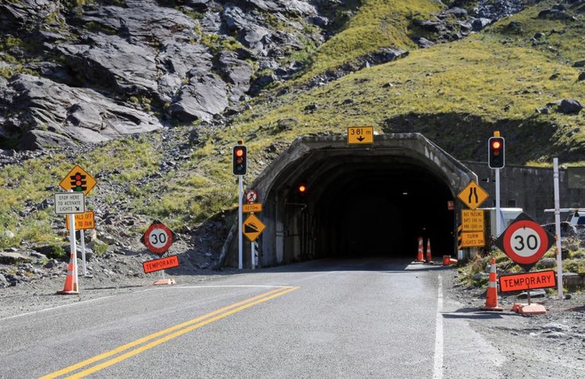
- High point: 940 metres above sea level at the Homer Tunnel, a 1.2 km single corridor tunnel at about 945 metres, controlled by traffic lights
- The programme: Avalanche control programme developed after a 1983 avalanche killed a road maintenance supervisor; run by the Milford Road Alliance, NZTA and Downer, based in Te Anau
- Winter rules: Between May and November, when signs require it, all vehicles must carry or fit snow chains, hireable in Te Anau; obey Avalanche Area No Stopping signs
- Current timed closures: Weeknight river protection works closures north of The Divide, Monday to Thursday 8 p.m. to 5 a.m. from 9 November 2026, expected to finish 11 December 2026, with a 10 p.m. opening for queued traffic and no detour
- Fuel and phones: No fuel stations between Te Anau and Milford Sound; mobile coverage is limited, so fill up and save bookings offline before leaving Te Anau
- Road status: Check NZTA Journey Planner or phone 0800 4 HIGHWAYS (0800 444 449) on the morning you drive
- Facts checked: 22 November 2026, against NZTA and Department of Conservation sources
Why does this road need an avalanche programme at all?
Because for most of its history, winter simply won. The road was built in the 1930s by Depression relief workers and finally completed in 1952, but it stayed closed through winter until the late 1970s, when tourism and fishing interests pressed successfully for year round operation. The cost of that ambition became clear in 1983, when a massive avalanche killed a road maintenance supervisor. The programme developed in response changed the philosophy: instead of reacting to avalanches, specialists forecast the hazard, rate the danger daily, close the road at defined risk levels, and use helicopter delivered charges to bring unstable snow down on their own timing, as in the controlled work at Avalanche Creek on the western side of the Homer Tunnel that NZTA has documented. The programme is internationally recognised, winning the International Road Federation Global Road Achievement Award for Programme Management in 2023, and the Milford Road Alliance that runs it also handles incident response, the Homer Tunnel and general maintenance from its Te Anau base.
How do closures and convoys actually reshape a Fiordland day?
In layers. The first layer is the avalanche gates, including at Marian Corner, 87 km from Te Anau, which close whenever avalanche danger threatens motorists, turning a Milford day into a Te Anau day at short notice. The second is the Homer Tunnel itself: a 1.2 km tunnel at altitude, worked as a controlled single flow, where traffic lights in busy periods can add delays of up to about 20 minutes, so a timetable built to the minute is a timetable built to fail. The third layer is planned works. This season, NZTA lists weeknight closures for river protection works between Hollyford Road and The Divide, Monday to Thursday from 8 p.m. to 5 a.m., running from 9 November 2026 to an expected finish on 11 December 2026, with the road opening briefly at 10 p.m. each closure night to release queued vehicles and no detour available. A traveller driving back from an evening at the fiord who reaches that section after 8 p.m. has three options: clear it before the closure, use the 10 p.m. opening, or wait until 5 a.m. None of these layers is hidden; all of them are published. The travellers they catch are the ones who planned from a status they read two days earlier.
What should a buffer day in Te Anau look like?
Not like a wasted day. Te Anau is the Alliance base town, the last fuel, the chain hire point and the place where the morning road decision gets made, and it sits on its own lake at the edge of Fiordland National Park with the Department of Conservation visitor infrastructure for the Kepler Track and the lakefront to fill a day easily. The buffer method is simple: book Milford for your first full day, hold the second day uncommitted, and swap the two if the first morning status is closed or high risk. Stay in Te Anau rather than Milford Sound itself the night before a self drive day, because the closure risk sits on the road between them. Carry or hire chains whenever the May to November signs require them, practise fitting them before you need them, and treat the Avalanche Area No Stopping signs as absolute, however good the photo looks. Pair this road planning with the entry side of the trip in our explainer on New Zealand NZeTA and the 100 dollar visitor levy, and with Nelson as the sunny Top of the South base if your route continues north after Fiordland.
How do you drive the day itself?
Check the NZTA road status before you leave Te Anau, not the night before. Fill the tank, because there are no fuel stations on the 240 km return. Save cruise bookings and maps offline, because coverage is limited. Leave earlier than the cruise timetable demands, because tunnel light delays, weather and photo stops at the Eglinton Valley and Mirror Lakes are certainties, not risks. And keep the return honest: if an evening works closure is in force, work backwards from the 8 p.m. gate, not forwards from a hoped for sunset. The Milford Road is one of the great drives in the world precisely because it crosses serious alpine country on a single thread of tarmac. The avalanche programme is what makes that thread usable in every season. Planning around it, with a buffer day and a morning status check, is not caution for its own sake; it is how the people who run the road intend it to be used.
Frequently Asked Questions
Why does the Milford Road close so often?
Because it crosses avalanche terrain at altitude, and the management system is deliberately conservative: the Alliance closes the road at defined hazard levels and runs controlled avalanche work to keep risk low, rather than keeping the road open and hoping.
When did the avalanche programme start?
It was developed after 1983, when a major avalanche killed a road maintenance supervisor. Before the programme era, the road simply closed all winter, as it had since completion in 1952 until year round operation began in the late 1970s.
Do I need snow chains for Milford Sound?
Between May and November, when road signs require it, all vehicles must carry or fit chains. Chains can be hired at Te Anau service stations. Check the morning road status for the requirement on your day.
Are there fuel stations on the Milford Road?
No. Department of Conservation guidance is clear that there are no fuel stations between Te Anau and Milford Sound, a 240 km return trip. Fill up in Te Anau.
What are the current night closures on SH94?
Weeknight closures for river protection works run Monday to Thursday, 8 p.m. to 5 a.m., between Hollyford Road and The Divide, from 9 November 2026 with an expected finish on 11 December 2026. The road opens at 10 p.m. on closure nights for queued traffic, and there is no detour.
How long does the drive from Te Anau to Milford Sound take?
At least two hours one way without stops, per NZTA, and longer with Homer Tunnel light delays, weather and sightseeing stops. Build the day around that minimum, not around the distance alone.