 Rafael Santos
Puno is the working port city on the Peruvian shore of Lake Titicaca, and it is the base from which almost every traveller visits the lake: the floating reed islands of the Uros, the knitting island of Taquile, and the pre Inca burial towers at Sillustani all run from its docks and roads. The lake itself sits at 3,812 metres above sea level and is widely described as the highest navigable lake in the world, shared between Peru and Bolivia and large enough, at more than 8,300 square kilometres, to feel like an inland sea. Puno demands honesty about altitude: the city stands higher than Cusco, the air is thin, the sun is fierce, and the first day should be slow. This guide explains what Puno is for, how the three classic visits work, and how to pace a stay so the altitude helps the experience instead of ruining it.
Quick Facts
- Where: Puno, on the western shore of Lake Titicaca in south eastern Peru, near the Bolivian border
- Lake altitude: 3,812 m above sea level; the highest navigable lake in the world for large vessels
- Lake size: More than 8,300 sq km, about 60 percent in Peru and 40 percent in Bolivia
- Uros islands: Floating islands built from totora reeds, a short boat ride from Puno port
- Taquile: A natural island about 35 km from Puno, famous for textile art recognised by UNESCO in 2005
- Sillustani: Pre Inca chullpa burial towers up to about 12 m tall, beside Lake Umayo north west of Puno
- City role: Transport hub and folklore capital of Peru, home of the February Candelaria festival
- Time needed: Two nights minimum, three if you add both a full lake day and Sillustani
Why does Puno sit so high, and why does it matter?
Puno stands on the Altiplano, the high plateau between the eastern and western ranges of the Andes. The lake surface is at 3,812 metres, and the city climbs the hills behind the bay from there, so most hotel rooms sit a little higher still. For comparison, Cusco is at about 3,400 metres, which means travellers who felt fine in Cusco can still be caught out here, especially if they arrive by a fast bus or a flight and transfer from sea level within a day or two.
Altitude sickness is the main health issue on this route, and it deserves plain language. Headache, poor sleep, breathlessness on stairs and a racing heart on arrival are common; serious symptoms such as confusion, severe breathlessness at rest or a worsening cough need medical help and descent, not perseverance. The standard defences work: arrive hydrated, avoid alcohol on the first night, eat lightly, walk slowly, and do not schedule the Taquile steps for your first morning. Coca tea is the local ritual and many hotels offer oxygen; neither replaces pacing. Build the lake days in ascending order of effort, Uros first, then Sillustani, then Taquile, and the altitude becomes manageable background rather than the story of the trip.
How do the Uros floating islands work?
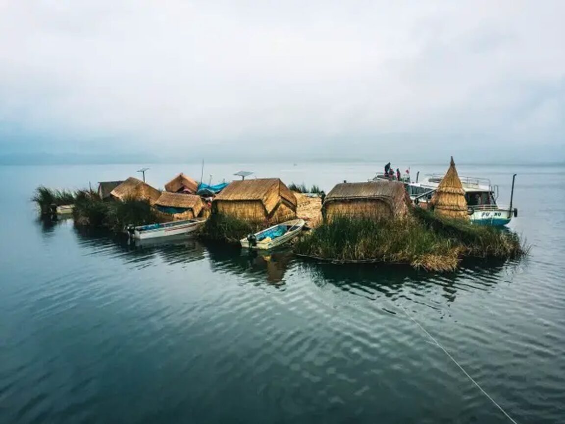
The Uros islands are the lake’s most famous sight, and they are exactly what the name promises: islands that float, built by hand from totora, the reed that grows in the shallows of Puno Bay. Island builders cut blocks of the dense root mass, which floats naturally, lash the blocks together, and lay crisscrossed layers of fresh reeds on top to form a springy walking surface. The lower layers rot in the water, so fresh reeds are added continually; an island is never finished, only maintained. Houses, watchtowers and the distinctive reed boats with animal head prows are built from the same plant.
The Uros people say their ancestors moved onto the water centuries ago to escape pressure from stronger neighbours, first the Colla and then the Inca, and the floating life became an identity: they call themselves the people of the lake. Today the archipelago numbers in the dozens of islands, the count shifting as islands are joined, split or rebuilt, and families combine fishing, crafts and tourism. Visits run as half day boat trips from Puno port, typically about 25 to 30 minutes each way. A host family explains the construction, shows the houses and offers a short ride in a reed boat. It is a presented visit and it is also a real community that has chosen tourism as part of its economy; treat it as a guest, buy crafts you actually like, and ask before photographing people.
What makes Taquile different?
Taquile is the opposite of the Uros: a solid natural island of red earth and stone paths, about 35 km from Puno and reached on the longer boat run, often combined with the Uros in a full day trip. Around 2,200 people live on Taquile, Quechua speaking, farming terraces and running one of South America’s most admired community tourism systems, in which visitor hosting and guiding rotate among families under community rules. There are no cars on the island, and the visit involves walking: a long stone stairway and paths climb from the dock to the main square, at an altitude that tops 3,900 metres. Go slowly.
Taquile’s fame is textile. In 2005 UNESCO proclaimed the textile art of Taquile a Masterpiece of the Oral and Intangible Heritage of Humanity, later carried on the Intangible Cultural Heritage list. The striking point for visitors is the division of labour: men knit, producing the fine, finely patterned caps whose colours and designs signal marital status and community role, while women weave belts and cloth on ground looms and spin the yarn. The cooperative shop in the square sells the genuine work at fixed prices. A Taquile day usually includes a trout lunch in a family restaurant and, on clear days, views across to Bolivia and the snow peaks of the Cordillera Real. Travellers continuing south into the Andes can pair this lake chapter with our explainer on the Salkantay Trek lodge route to Machu Picchu, which applies the same altitude pacing logic to a multi day walk.
What are the towers at Sillustani?
Sillustani is Puno’s essential land excursion: a pre Inca necropolis on a peninsula above Lake Umayo, roughly 35 to 40 km north west of the city and usually visited as an afternoon half day trip. Its monuments are chullpas, funerary towers built by the Colla people, who dominated this shore before the Inca absorbed the region in the 15th century, and later refined under Inca influence. The towers are round or square in plan, built of fitted stone, and the tallest reach about 12 metres. They held the mummified remains of nobles, placed to face the rising sun, with goods for the afterlife.
The finest tower, known as the Lizard Chullpa, shows the engineering clearly: a slightly tapering cylinder of carefully dressed blocks with a small eastern entrance. The setting does half the work. Late afternoon light over Lake Umayo, wild vicuña relatives and water birds on the shore, and almost none of the crowds of the lake circuit make Sillustani the quiet favourite of many Puno stays. Because the trip runs in the afternoon, it pairs naturally with a morning on the Uros islands, leaving Taquile for its own full day.
What is Puno itself like?
Puno is a working city, not a resort, and it is better for setting expectations that way. The useful centre is compact: the Plaza de Armas and cathedral, the pedestrian Jiron Lima with its cafes and agencies, the Carlos Dreyer Museum of regional archaeology, and the port and bayfront below. The Mirador del Condor viewpoint above town gives the orientation view over the bay and the island dotted lake beyond. Puno calls itself the folklore capital of Peru, and in February the claim becomes visible: the Fiesta de la Candelaria, recognised by UNESCO in 2014 on the Intangible Cultural Heritage list, fills the streets with tens of thousands of dancers and musicians in one of South America’s largest festivals. Outside February, the city is a practical, friendly base whose restaurants serve lake trout, quinoa soups and Altiplano staples.
Getting there and away is straightforward. Trains and buses link Puno with Cusco across the Altiplano, buses continue to Arequipa and to the Bolivian border crossings toward Copacabana and La Paz, and the nearest airport is at Juliaca, about an hour away by road. For a South American lake and falls contrast at the other end of the altitude scale, see our stay guide to Hotel das Cataratas inside Iguazu park. Whatever the onward plan, keep one buffer: at this altitude, a slow first day in Puno is not lost time, it is what makes the rest of the lake work.
Frequently Asked Questions
Is Lake Titicaca really the highest navigable lake in the world?
Yes, in the standard sense of the term: at 3,812 m it is the highest lake navigable by large vessels. Smaller bodies of water exist at higher altitudes, but none carries commercial boat traffic on Titicaca’s scale. It is also South America’s largest lake by volume of water.
How do you visit the Uros islands?
By boat from Puno port, usually on a half day trip of about three hours including roughly 25 to 30 minutes sailing each way. A host family explains how the reed islands are built and maintained. Full day trips combine the Uros with Taquile.
What is Taquile known for?
For its textile art, recognised by UNESCO in 2005, and specifically for knitting done by men, whose patterned caps carry social meaning. Taquile is a natural island about 35 km from Puno with no cars, community run tourism and a demanding stair climb from the dock.
How serious is the altitude in Puno?
Serious enough to plan around. Puno is higher than Cusco at over 3,800 m. Take the first day slowly, avoid alcohol, hydrate, and order your excursions by effort. Seek medical help and descend if symptoms become severe or include confusion or breathlessness at rest.
What is Sillustani and how long does it take?
Sillustani is a pre Inca burial site of stone chullpa towers, the tallest about 12 m, beside Lake Umayo roughly 35 to 40 km from Puno. It is normally a half day afternoon trip and combines well with a morning visit to the Uros islands.
When is the best time to visit Puno?
The dry season, roughly May to October, brings the clearest skies and coldest nights. February brings the Candelaria festival and the wettest weather. Year round, expect strong sun by day and temperatures dropping sharply after dark at this altitude.