 Lucas Meyer
Beyond the postcard spires, Pinnacles National Park rewards the visitor who makes two decisions well: which entrance to use, and where to look for condors. The east and west entrances are not connected by any road through the park, and choosing the wrong one adds a long drive around. The California condors, meanwhile, favour the High Peaks in the morning, and the talus caves, Bear Gulch on the east side and Balconies on the west, open and close with the bats, so the cave status page, not habit, should set the day plan.
Quick Facts
- Park: Pinnacles National Park, central California
- Entrance fee: 30 dollars per private vehicle, 25 dollars per motorcycle, 15 dollars per person on foot or bicycle, each valid 7 days; Pinnacles Annual Pass 55 dollars
- East entrance: Via Highway 25 and Highway 146 near Paicines; campground, visitor center, Bear Gulch Cave
- West entrance: Via Highway 146 from Soledad and US 101; day use only, gate hours 7:30am to 8pm
- No through road: The two sides connect only by hiking trails, never by car
- Condors: Pinnacles is a release and management site for the California Condor Recovery Program, running since 2003
- Caves: A flashlight or headlamp is required in the talus caves; check the NPS cave status page before you go
East or west: why the entrance choice decides the day
Pinnacles is one park with two front doors and no corridor between them. The east entrance, reached from Hollister via Highway 25, is the full service side: the park campground, the main visitor center, the Bear Gulch day use area, the reservoir, and trailheads for the Condor Gulch and High Peaks routes. The west entrance, reached from Soledad via Highway 146, is the quiet side: a contact station, the Chaparral trailhead, the Balconies Cave and Cliffs loop, and the Juniper Canyon route into the High Peaks, with day use only and a gate that opens at 7:30am and closes at 8pm. Driving between the two entrances means leaving the park and travelling around it, the better part of an hour and a half or more depending on route and traffic. So the choice is not a detail. Campers, cave visitors targeting Bear Gulch, and anyone wanting an early or late day belong on the east. Visitors based in Monterey, Salinas or Soledad, and hikers who want the Balconies Cave and a quieter trailhead, belong on the west. Everyone should decide before leaving the highway, because there is no correcting the mistake inside the park.
Where do you actually see condors?
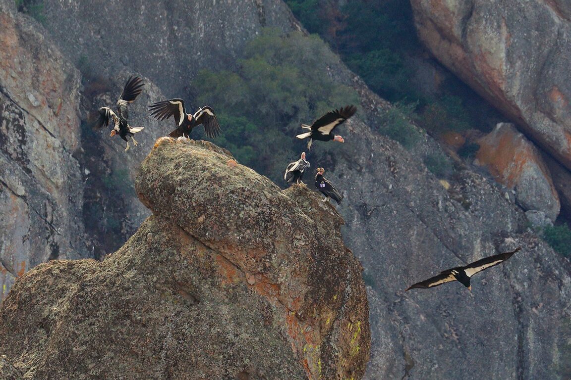
The California condor is the largest land bird in North America, with a wingspan of up to about 9.5 feet, and Pinnacles has been a release site for the recovery program since 2003, managed with the Ventana Wildlife Society. The free flying flock over the park is one of the great wildlife sights in California, but it is never guaranteed, and the honest advice is about odds, not promises. Condors ride thermals, so they are most active once the day warms, typically from mid morning, and they favour the High Peaks, the rocky spine at the centre of the park. The Condor Gulch Trail from the east side climbs 1.7 miles to an overlook built for exactly this, and the High Peaks Trail loop beyond it, about 5.3 miles round trip with roughly 1,300 feet of climbing via Condor Gulch, is the classic condor hike. Look for the numbered wing tags every managed condor carries, and use the park condor profiles to identify individuals. Bring binoculars, scan the ridgelines rather than the sky at random, and give the birds the distance the park asks for: these are intensively managed, critically endangered birds, and approaching or feeding them is prohibited. Visitors who have done the reservation dance at other parks will recognise the planning style; it is the same patience rewarded in Acadia Cadillac Mountain vehicle reservations, applied to wildlife instead of parking.
What makes the caves different, and why do they close?
The Pinnacles caves are talus caves, passages formed where fallen boulders jammed into narrow gorges, and they are the park second signature experience. Bear Gulch Cave, on the east side via the Moses Spring Trail, shelters a maternity colony of Townsends big eared bats, and the park closes it seasonally to protect the colony, typically a full closure from around mid May to mid July for the maternity season, with partial openings at other times of year. Balconies Cave, on the west side loop, hosts bats too but not a maternity colony of the same sensitivity, and it is usually open more of the year, though closures can happen at short notice on either side. Two rules follow. First, check the NPS cave status page on the morning of your visit, because the two caves rarely follow the same schedule and a cave based plan should follow whichever cave is open. Second, carry a headlamp for every person: the cave interiors are completely dark, the floors are uneven, and a headlamp keeps hands free for the scrambles. A phone light is a poor substitute underground.
How should a beyond the postcard day be sequenced?
From the east, start early at Bear Gulch: Moses Spring Trail to the cave and the reservoir in the cool of the morning, then climb Condor Gulch toward the High Peaks as the thermals build and the condors come up. From the west, walk the Balconies loop first, cave then cliffs, and continue up Juniper Canyon if the day and the heat allow. Heat is the park governing fact in summer and early autumn: the interior valleys get extremely hot, there is no water on the trails, and the park consistently advises carrying far more water than feels necessary, starting at dawn, and treating midday as rest time. Spring is the gentler season, with wildflowers and milder temperatures, and winter days, like the season explored in Cuyahoga Valley National Park in winter, trade crowds for short days and cold mornings. Whatever the season, download or carry the park map before you arrive: mobile coverage inside the park is unreliable, and the east west decision, the cave status and the trail plan should all be settled while you still have signal.
What else lives beyond the famous sight?
Spend time on the smaller print of the park and it stops being a single viewpoint. The rock itself is the eroded remnant of an ancient volcano, carried north along the San Andreas Fault, which runs close to the park, and the spires, cliffs and boulder caves are all chapters of that one geological story. Prairie falcons nest on the cliffs, and climbing routes on the formations are subject to seasonal raptor closures that protect them. The campground on the east side, the only camping in the park, puts visitors inside the condor flight paths at dawn and dusk and offers ranger programs in season. Night brings genuinely dark skies. None of it requires the summit photograph. It requires the entrance decision made correctly, a headlamp, water, binoculars, and a morning given to the High Peaks.
What about the west side trails most visitors skip?
The west side repays anyone who treats it as more than a cave stop. The Balconies Cliffs Trail above the cave gives the park most dramatic wall of rock at close range, the Prewett Point Trail near the contact station is a short viewpoint walk of under a mile, and the Juniper Canyon Trail climbs into the High Peaks from the quieter side, meeting the same condor country the east side routes reach. Hikers with two days should walk one side per day rather than attempting a cross park traverse, which is a long, exposed undertaking with no water and no shortcut back. Splitting the park that way also doubles the condor chances: two mornings in the High Peaks flight zone instead of one.
Frequently Asked Questions
Can you drive through Pinnacles from one entrance to the other?
No. There is no road connecting the east and west entrances inside the park. The sides connect only by hiking trails, and driving between entrances means going around the park.
How much does Pinnacles cost to enter?
The entrance pass costs 30 dollars per private vehicle, 25 dollars per motorcycle and 15 dollars per person on foot or bicycle, valid for 7 days. The Pinnacles Annual Pass costs 55 dollars, and America the Beautiful passes are accepted.
Where is the best place to see California condors?
The High Peaks area, reached by the Condor Gulch Trail and the High Peaks Trail from the east side, is the most reliable area, especially from mid morning as thermals build. Sightings are never guaranteed.
Why is Bear Gulch Cave sometimes closed?
The cave shelters a maternity colony of Townsends big eared bats, and the park closes it seasonally, typically from around mid May to mid July, to protect the colony. Always check the NPS cave status page before a visit.
What are the west entrance hours?
The west entrance is day use only, with gate hours of 7:30am to 8pm. The east side, including the campground, works on a longer day, which is why campers and early starters use the east.
What should I carry for the caves and the High Peaks?
A headlamp for every person for the caves, binoculars for condors, sun protection, and substantially more water than you expect to need. There is no water on the trails and summer heat is extreme.
Sources checked 16 November 2026: National Park Service Pinnacles pages (nps.gov/pinn) on fees, entrances, cave status and condor program, and park trail descriptions. Cave status changes at short notice; recheck on the day.