 Rafael Santos
Kennecott is not a base you day trip from by accident. It is a ghost copper town at the end of a 59 mile gravel road, inside the largest national park in the United States, and getting there consumes half a day by itself. That is exactly why the day trips out of it need to be chosen well. The strong hand is three moves: the guided mill tour, booked with the park’s concessioner because it is the only way inside the 14 story concentration mill; the Root Glacier hike, four miles round trip from the mill town onto the most accessible ice in a park holding some 5,000 square miles of glaciers; and two more detours worth the effort, the living village of McCarthy five miles back down the road, and the Bonanza Mine trail climbing to the ridge where the copper came from. Wrangell-St. Elias charges no entrance fee, the Kennecott Visitor Center runs daily from late May to mid September, and every one of these trips is seasonal, so the planning below is built for the summer window when the shuttles, tours and visitor center are actually operating.
Quick Facts
- Base: Kennecott mill town, a National Historic Landmark inside Wrangell-St. Elias National Park and Preserve, Alaska
- Entrance fee: None. Wrangell-St. Elias has no entrance stations and charges no entrance fee, per the National Park Service
- Getting there: The McCarthy Road runs about 59 miles of gravel from Chitina to the Kennicott River footbridge; allow two to three hours, and note there is no fuel along the road
- Last stretch: No private vehicles beyond the footbridge. Walk about five miles, cycle, or take the commercial shuttle from McCarthy to Kennecott
- Visitor center: Kennecott Visitor Center, in the old Blackburn School, May 23 to September 13, daily 9 a.m. to 5 p.m. in the park’s published schedule
- Mill tour: Guided only, with St. Elias Alpine Guides, the park concessioner; about two hours, listed at $36 per adult and $18 per child in 2026
- Checked: Hours, access and tour facts verified against nps.gov and the concessioner on November 17, 2026
How do you get to Kennecott in the first place?
The deciding evidence in favour of Kennecott over nearer, easier alternatives is also the cost of entry: the journey filters out everyone who is not serious. From Chitina, the McCarthy Road follows the bed of the old Copper River and Northwestern Railway for about 59 narrow, winding gravel miles to the Kennicott River. The park’s own road guide warns that the surface can be rough, that there is no fuel along the way, and that the drive takes two to three hours in good conditions. Fill up in Chitina or Kenny Lake, carry a full size spare, and treat the road as part of the experience, because it crosses the Kuskulana Bridge and passes lake after lake beneath the Wrangell Mountains.
At the end of the road, private vehicles stop. You park, cross the Kennicott River on the pedestrian footbridge into McCarthy, and cover the last five miles to Kennecott on foot, by bicycle or on the commercial shuttle that meets arrivals at the bridge. That final stretch is why day trips from Kennecott need a base decision: sleep in McCarthy or at the lodge in Kennecott itself and the trips below are morning starts; try to day trip Kennecott from outside the valley and the road arithmetic defeats you. The park’s scale explains the rest of the planning. Wrangell-St. Elias covers more than 13 million acres, and the Kennecott district is its one developed historic corner, which is why everything in this guide radiates from a single mill town street. Readers weighing Alaska’s other great road corridor can compare this with our guide to Denali’s Teklanika River corridor for first timers.
How does booking the mill tour work?
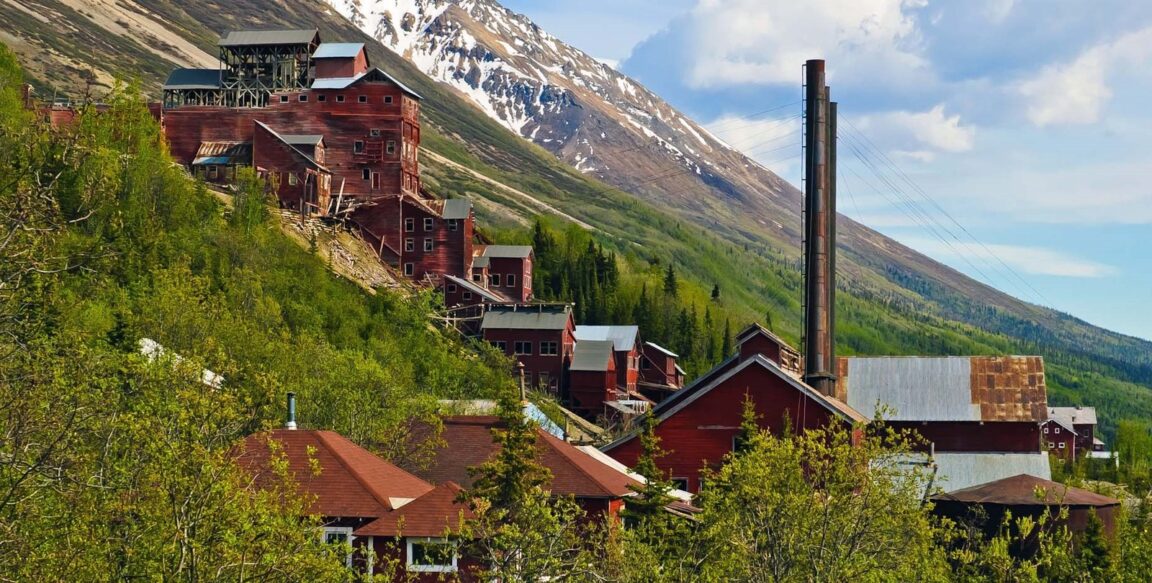
Book it first, and build the day around it, because the mill is the one sight in Kennecott that cannot be done independently. The 14 story concentration mill, the great red timber building stepping down the hillside, is open only on guided tours run by St. Elias Alpine Guides, the park’s concessioner. The National Park Service confirms the arrangement plainly: the concessioner’s history tours are the only way to see inside the concentration mill building and the leaching plant, the tours run about two hours, and they are offered several times a day through the summer. The concessioner’s 2026 listing prices the mill town tour at $36 for adults and $18 for children 12 and under, with departures through the day in season; reserve ahead in July and August, when the small number of daily departures fills.
The rest of the town, by contrast, is yours to wander free. Kennecott was listed on the National Register of Historic Places in 1978 and designated a National Historic Landmark in 1986, and the Park Service, which acquired most of the town in 1998, calls it the best remaining example of early 20th century copper mining. From 1911 to 1938 the operation processed nearly $200 million worth of copper, with about 300 people working in the mill town and hundreds more in the mines above. The General Store and Post Office holds the most extensive exhibits, including the short film on the mill; the North Sacking Shed carries a scale model of Bonanza Ridge; and the General Manager’s Office, the oldest building in town, shows panoramic photographs of how the glacier and town have changed. Start at the Kennecott Visitor Center in the Blackburn School for orientation and the day’s ranger programs, then let the guided tour supply the interior the self guided town cannot.
Is the Root Glacier hike the best half day from Kennecott?
Yes, and it is not close. Of the roughly 5,000 square miles of glacial ice in Wrangell-St. Elias, the Root Glacier is the most accessible piece, reached by a moderate walk of about a mile and a half from the mill town along the Root Glacier Trail. The park’s trail description gives the full outing as four miles round trip from Kennecott to the glacier, taking two to six hours depending on how long you spend on the ice. The route walks you through the mill town, crosses Bonanza Creek and Jumbo Creek, and winds through the lateral moraines of the Kennicott and Root Glaciers, with views of Mount Blackburn, Regal Mountain and Donoho Peak, before a short access trail drops to the toe of the ice.
Two cautions belong in the plan. The park recommends crampons or ice spikes and travelling with an experienced guide, because glacier ice is slippery and the edge of the glacier, with rotting ice and swift cold water, is genuinely hazardous; guided half day glacier hikes run out of Kennecott and McCarthy all summer for travellers who want the gear and the judgement supplied. And because moraine routes shift as the ice moves, confirm the current access route at the Kennecott Visitor Center before you set out. Bears use the whole corridor, so travel in a group and make noise. Paired with a morning or late afternoon mill tour, the Root Glacier makes the single best full day the town offers: industry in the morning, ice after lunch, and the red mill buildings turning gold in the evening light for the walk back.
What are the two more detours worth making?
The first is McCarthy, the living village five miles back toward the footbridge, and it earns its place as the social half of the district. McCarthy was the miners’ town, where the company rules of Kennecott did not apply, and today it holds the valley’s restaurants, saloon, museum and guide services, plus the shuttle stop that connects everything. Walk or ride down for dinner, or give it a morning: the contrast between preserved, ranger run Kennecott and working, private McCarthy is the most instructive comparison in the park, and it is free.
The second detour is vertical. The Bonanza Mine Trail climbs from the mill town toward the ridge mines where the ore actually came from, roughly 5.6 miles round trip with about 2,900 feet of elevation gain on published trail figures, a strenuous half to full day that repays the effort with the tram lines, mine structures and a view down over the mill, the glaciers and the whole Kennicott valley. The Jumbo Mine trail branches from the same fork in the road about half a mile beyond the visitor center. Neither ridge trail is a casual stroll, and both are weather dependent, but for travellers who found the mill tour raised more questions than it answered, standing at the mine mouths is the answer. A third option, flightseeing over the icefields out of McCarthy, is the splurge: an hour in the air does more to communicate the size of this park than a week on the ground. For another park where a single corridor concentrates the whole visit, see our first timer guide to Everglades’ Shark Valley.
When should you come, and what closes the argument?
Come between late May and mid September, because outside that window Kennecott effectively shuts: the park confirms that all visitor contact stations close from October through April, the shuttles and tours are summer only, and the McCarthy Road, unmaintained in winter, becomes a ski and snowmachine proposition rather than a drive. Weighed against the alternatives, that seasonality is the honest trade. The Nabesna Road, the park’s other road, offers wilderness with almost no services or sights. Denali offers more infrastructure at far greater crowd pressure. Kennecott offers the single most complete historic industrial landscape in the national park system, a walk-on glacier, and a road that keeps the numbers down. Book the mill tour, walk to the ice, eat in McCarthy, and climb to Bonanza if the weather smiles. That is the order, and it is enough.
Frequently asked questions
Can you drive all the way to Kennecott? No. The McCarthy Road ends at the Kennicott River after about 59 gravel miles from Chitina. You park there, cross the footbridge to McCarthy, and continue the last five miles to Kennecott on foot, by bicycle or by commercial shuttle.
How do you book the Kennecott mill tour? Through St. Elias Alpine Guides, the park concessioner, which runs the only tours inside the concentration mill and leaching plant. Tours last about two hours, run several times daily in summer, and were listed at $36 per adult and $18 per child in 2026. Book ahead in peak season.
How long is the Root Glacier hike? Four miles round trip from Kennecott, taking two to six hours. The park recommends crampons or ice spikes and suggests going with an experienced guide; confirm the current access route at the visitor center before setting out.
Is there an entrance fee for Wrangell-St. Elias? No. The park has no entrance stations and charges no entrance fee. Costs on this trip are the guided tours, shuttles, lodging and food.
When is Kennecott open? The visitor season runs from late May to mid September. The Kennecott Visitor Center’s published schedule is May 23 to September 13, daily 9 a.m. to 5 p.m., and all park visitor centers close from October through April.
Photo: The red mill buildings of the Kennecott mill town on their hillside above the Kennicott Glacier valley. Photo by Bryan Petrtyl, National Park Service, via nps.gov.