 Priya Nair
Do the Savage River section first, and treat Teklanika as a privilege with conditions attached. That is the honest first timer’s answer for Denali’s Teklanika River corridor. In the main summer season almost every private vehicle must turn around at Savage River, around Mile 15 of the single 92 mile Denali Park Road, while the Teklanika River, its rest area at Mile 30 and its campground at Mile 29 are reached by park bus, by a campground reservation with strict rules, or, for a short weather dependent window each autumn, by private car when the National Park Service opens the road beyond Savage River. Settling which of those three doors is open on your dates is the whole game, and it has to be settled before bases, buses and budgets.
Quick Facts
- The road: One road, the 92 mile Denali Park Road. There is no other vehicle route into the park interior.
- Summer car limit: Private vehicles may drive the first 15 miles, to the Savage River area, in the main season. Beyond that, travel is by park bus.
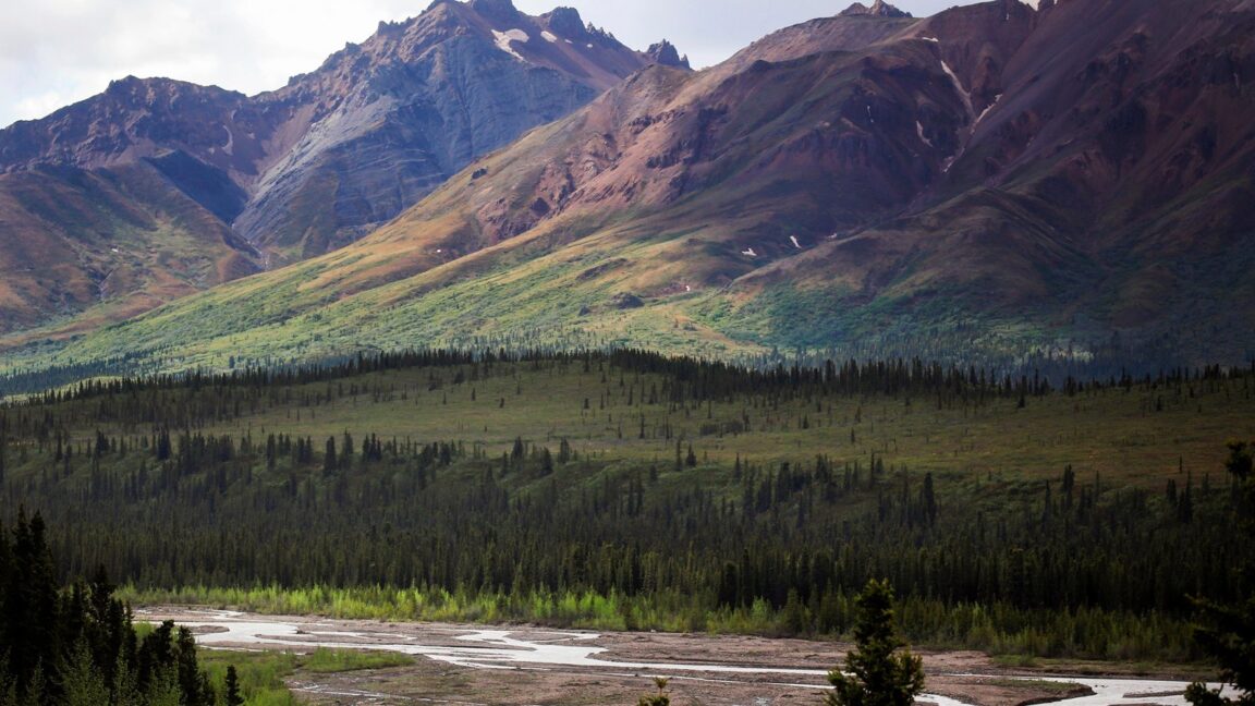
- Teklanika Rest Area: Mile 30 on the park road, on the Teklanika River, a wide braided glacial river below the Alaska Range foothills.
- Teklanika Campground: Mile 29.1, 53 sites for tents and RVs, open May 20 to mid September. Campers who drive in must stay a minimum of three nights and keep their vehicle parked at the campsite for the whole stay, per the National Park Service campground page.
- Autumn opening: In 2026 the park opened the road to private vehicles as far as Teklanika Rest Area from 18 September, weather and road conditions permitting, with fall access continuing as conditions allowed through 15 October.
- Entrance: Denali charges a per person entrance fee, listed at $15 per person for seven days in park fee information at research time. Confirm the current fee on the park website before you go.
- Facts checked: 17 November 2026, against National Park Service pages cited in this guide.
Why Does Everyone Stop at Savage River?
The Savage River checkpoint, around Mile 15, is where the paved, freely drivable park road effectively ends for private cars in summer. Savage River itself, with its canyon trails, picnic area and campground at Mile 13, is a worthwhile destination rather than a consolation prize, and for many first timers it is the correct full stop: the river loop trail, the mountain views and a real chance of wildlife, all without a bus ticket. Everything beyond it, including the gravel road over the foothills to Teklanika, belongs to the bus system for most of the year. That single rule protects both the road, which is narrow and gravel surfaced beyond Savage River, and the wildlife that uses the corridor.
There is a second, harder limit further in. Since 2021 the road has been closed at the Pretty Rocks landslide around Mile 43, and in recent seasons buses have run no further than the East Fork area near Mile 43. Teklanika, at Mile 29 to 30, sits comfortably before that closure, which is why the corridor works as a first timer target: it is deep enough into the park to feel like the interior, with the braided river, open tundra slopes and the Alaska Range rising behind, and it is reachable without depending on the closed section.
What Are the Three Ways to Reach Teklanika?
The first is the park bus. In the summer season, transit and tour buses run the road beyond Savage River, and a bus day out to the Teklanika River rest stop and back is the standard way most visitors experience the corridor. Book bus seats as early as your dates allow, because the system is the only public transport the park has and peak season departures are finite.
The second is the campground exception. Teklanika River Campground, described in full on the National Park Service Teklanika Campground page, is the one place where private vehicles may pass Savage River in summer, and the trade is explicit: a three night minimum stay, and your vehicle stays parked at your site for the duration while you get around by bus. The road between Savage River and the campground at Mile 29 is gravel. For campers who want to wake up on the Teklanika River, hear the park at night and walk the river bars at the quiet ends of the day, that trade is the best value in Denali. For anyone wanting to come and go daily, it is the wrong product.
The third is the autumn opening. When the bus season ends, the park has in recent years opened the road to private vehicles as far as Teklanika for a short fall window. The 2026 notice, published as Denali Park Road Opens to Private Vehicles to Teklanika, set the opening for Friday 18 September, weather and road conditions permitting, with access continuing as conditions allowed through 15 October, and with the clear warning that snow and ice could pull the limit back to Mountain Vista at Mile 13 or even park headquarters at Mile 3.4 with little notice. Campgrounds wind down on the same clock: in 2026 the final night at Teklanika Campground was 17 September and Savage River Campground closed on 20 September.
What Happened to the Denali Road Lottery?
First timers often arrive expecting the old road lottery to be their route in. Plan instead around the systems above. Access beyond Savage River is now handled through the bus network, the Teklanika campground exception and the announced autumn opening, and the autumn opening in particular is a conditions based privilege, not a guaranteed permit. The practical translation is simple: if driving your own car to Teklanika matters to you, build a trip around the mid September to mid October window, keep a Savage River plan ready for the days the road is shortened, and read the park’s current conditions on the morning you drive. The National Park Service page for the Teklanika River Rest Area sets out what the stop itself offers once you get there.
Where Should a First Timer Base for the Teklanika Corridor?
Base choice follows the access choice. Bus riders and Savage River drivers do best at the park entrance area, including Riley Creek Campground and the lodging cluster outside the entrance on the Parks Highway, because every plan starts at the same mile zero. Teklanika campers trade that flexibility for position: three nights minimum inside the corridor, supplied and self sufficient, with the river as the front yard. Autumn drivers should stay flexible and close, since a road that opens to Mile 30 on a clear morning can be a Mile 13 road by the next snowfall. Denali also rewards comparison shopping across park styles: travellers building a wider parks trip can see how a desert monument handles day trips in our guide to day trips around Bandelier National Monument, and how a canyon park punishes poor planning in our list of Black Canyon of the Gunnison mistakes to avoid.
What Should You Actually Do at Teklanika?
Walk the river. The Teklanika is a classic braided glacial river, its channels dividing and rejoining across a wide gravel bed, and the rest area at Mile 30 is built for exactly that encounter: short paths, river views, and the foothills of the Alaska Range filling the background. Carry bear aware habits everywhere in this corridor, store food properly at camp, and give moose and bears the distance the park prescribes. Weather is a co author of every Denali day, so layers, waterproofs and a plan that survives low cloud are not optional extras. And keep the mountain in perspective: Denali itself is famously shy, hidden by its own weather much of the time, which is another reason the Teklanika corridor earns its place. The river, the tundra and the foothills deliver on an ordinary day, whether or not the high peak shows itself.
Frequently Asked Questions
Can you drive your own car to Teklanika in summer?
Only in one case: with a reservation at Teklanika River Campground, where you may drive to Mile 29, stay at least three nights and leave the vehicle parked at your site while you use the buses. Otherwise the summer limit for private vehicles is Savage River at about Mile 15.
When can private vehicles drive to Teklanika Rest Area?
During the short autumn opening after the bus season ends. In 2026 that began on 18 September, weather permitting, and was expected to continue as conditions allowed through 15 October, with the limit liable to shorten to Mile 13 or Mile 3.4 in snow or ice. Always check the park’s current conditions before setting out.
How do most visitors reach the Teklanika River?
By park bus. Buses are the park’s transport system beyond Savage River in the main season, running as far as the Pretty Rocks closure area, and a bus day to Teklanika and back is the standard first timer experience of the corridor.
Is Savage River worth stopping at if you cannot reach Teklanika?
Yes. Savage River, at the end of the freely drivable road, has canyon trails, a picnic area and a campground at Mile 13, and it gives a genuine Denali day of river, mountains and wildlife chances without any bus booking at all.
How many nights do Teklanika campers have to stay?
Three nights minimum if you drive your own vehicle in, per the National Park Service, and the vehicle must remain parked at your campsite for the whole stay. The campground has 53 sites and is open from 20 May to mid September.
Does the road go all the way through Denali?
The park road is 92 miles long, but it has been closed at the Pretty Rocks landslide around Mile 43 in recent seasons, so no visitor traffic, bus or private, currently runs the full road. Teklanika at Mile 29 to 30 is well before the closure.