 Lucas Meyer
The mistakes that spoil a Black Canyon of the Gunnison day are almost all sequencing mistakes: driving the South Rim Road in the wrong order for the light, saving Warner Point for when legs and water are gone, assuming a timed ticket exists when none does, and basing the whole plan in the wrong town. Get four things right and the park becomes simple. Drive the 7-mile South Rim Road from Tomichi Point to High Point in order, stopping at Gunnison Point, Chasm View and Painted Wall View on the way. Walk the Warner Point Nature Trail, about 1.5 miles round trip from High Point, while you are fresh. Pay the standard entrance fee, $30 per private vehicle for 7 days, with no reservation required for entry. Base in Montrose, about 15 minutes from the South Rim entrance on Highway 347. The traps below are what happen when any of that order slips.
Quick Facts
- Location: Western Colorado. South Rim entrance at 9800 Highway 347, Montrose, CO 81401, reached 7 miles north on CO 347 from US Highway 50 east of Montrose.
- Entrance fee: $30 per private vehicle, $25 per motorcycle, $15 per person on foot or bicycle, each valid 7 days. Park annual pass $55. America the Beautiful passes accepted. Youth 15 and under free. No timed entry reservation for park entry.
- South Rim Road: About 7 miles, Tomichi Point to High Point, with 12 overlooks. Open to vehicles roughly late April to mid-November beyond the visitor centre; in winter the road is open only to the visitor centre area and the outer section serves skiers and snowshoers.
- South Rim Visitor Center: At Gunnison Point, near the start of the drive. The park is open 24 hours; the South Rim itself has limited mobile coverage and none inside the canyon.
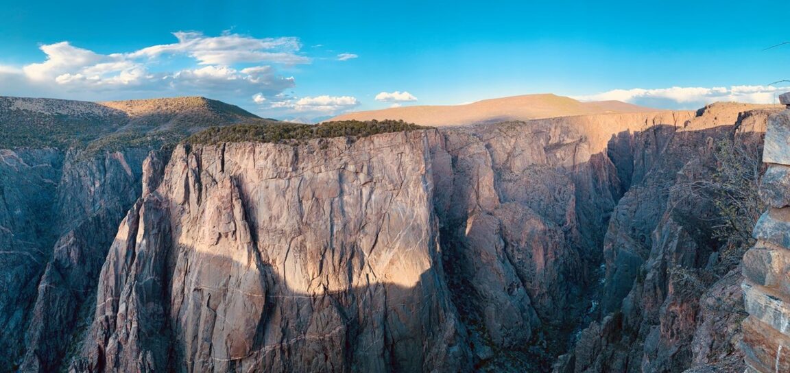
- Deepest point: 2,722 feet at Warner Point. The Painted Wall, viewed from Painted Wall View, is the tallest cliff in Colorado at about 2,250 to 2,270 feet.
- Warner Point Nature Trail: About 1.5 miles round trip from High Point at the end of the road. Allow 45 minutes to 1 hour with stops.
- Inner canyon warning: Routes below the rim, including Warner, Gunnison and Tomichi routes, require a wilderness permit in season, reserved via Recreation.gov for South Rim routes from May to October. They are steep, unmarked wilderness descents, not rim walks.
- Fire recovery note: The lightning-caused South Rim Fire closed the whole park from 10 July 2025. The North Rim reopened 30 July 2025 and South Rim Road reopened in stages from late August 2025. Check current NPS alerts before travel, because burned-area hazards and facility repairs can still close individual trails.
What is the right order to drive the South Rim Road?
Drive it west, in the order the road gives you, and resist the urge to cherry-pick from a listicle. The sequence runs: Tomichi Point first, the gentle introduction where the canyon is still V-shaped; then the South Rim Visitor Center and Gunnison Point directly behind it, the most popular overlook in the park and the place to collect maps, water and the day’s alert sheet; then Pulpit Rock; then the close cluster of Cross Fissures, Rock Point and Devils Lookout; then Chasm View, where the walls fall about 1,840 feet in only 400 horizontal feet and most visitors rate the single most dramatic stop; then Painted Wall View, a short walk away, facing the tallest cliff in Colorado; then Cedar Point and Dragon Point; then Sunset View, the westernmost road overlook with picnic tables; and finally High Point, the turnaround, picnic area and trailhead for Warner Point. Stopping in this order does three things: it front-loads the visitor centre, it pairs Chasm View and Painted Wall while you are parked once, and it saves the one real walk for the end of the road where it belongs, instead of scattering hikes along the drive.
The light argues for the same order with an early start. Morning light reaches the east-facing walls and the Painted Wall face while afternoon puts much of the inner canyon into the shadow that gives the park its name. A late start compresses everything into the flat midday hours and the crowded early afternoon. If you can only make three stops, NPS guidance has long pointed to the same trio this guide does: Gunnison Point, Chasm View and Painted Wall View, with Sunset View swapped in if your day runs late.
Which ticket and timing traps catch people out?
Trap one is inventing a reservation that does not exist. Black Canyon has no timed entry system for 2026: you pay the entrance fee or show a pass and you drive in. Travellers who arrive expecting to be turned away for lacking a booking sometimes waste the best light of the day solving a non-problem. Trap two is the reverse error below the rim: inner canyon routes do need a wilderness permit, South Rim routes are reserved on Recreation.gov in the May to October season, and a campground reservation or an entrance pass does not substitute for one. Trap three is the season trap. Beyond the visitor centre, South Rim Road is a fair-weather road, open to cars roughly late April to mid-November and closed to vehicles in winter, when only the entrance to visitor centre section is ploughed. Trap four is the cashless and connectivity trap: buy a digital pass in advance if you can, download maps offline before Montrose, and never build a plan that needs a phone signal at an overlook, because coverage is limited on the rim and absent in the canyon. Trap five is fire recovery: after the July 2025 South Rim Fire, which burned 4,232 acres and closed the park entirely for weeks, individual trails and facilities have reopened in stages, with Oak Flat and Uplands trails only fully repaired by November 2025. The alert page, checked the morning of the visit, outranks any guide, including this one.
For contrast with a park that really does ration entry, read our explainer on Arches National Park timed entry 2026, and for another mistakes format done properly, our Gateway Arch National Park mistakes guide.
How should Warner Point fit the day, and who should skip it?
Warner Point is the reward at the end of the road, and the mistake is treating it as an afterthought. The nature trail leaves High Point and runs about 1.5 miles round trip to the deepest view in the park, 2,722 feet down to the Gunnison River, with the San Juan Mountains filling the western horizon on a clear day. Walk it on arrival at High Point, not after a long picnic, because afternoon thunderstorms in summer and simple fatigue both punish delay. Carry water for the walk even though it is short: High Point sits at high elevation, the trail is exposed, and there is no water at the trailhead. Who should skip it? Anyone already struggling with the elevation, anyone facing a building storm, and anyone whose schedule would trade Chasm View and Painted Wall for it. The overlooks are the park; Warner Point is the park’s best walk, which is a different claim. Do not confuse the Warner Point Nature Trail with the Warner Route into the canyon: same name, entirely different undertaking, and the route requires a wilderness permit and genuine descent fitness.
Why does the Montrose base matter, and what goes wrong from further away?
Montrose is the correct base because the South Rim is a Montrose park in every practical sense: about 15 minutes from town to entrance station via US 50 and Highway 347, with fuel, food, lodging and the last reliable phone signal. Basing in Montrose lets you start the rim early, retreat for lunch without surrendering the day, and return for Sunset View in the evening. The classic error is basing in Gunnison or Crested Butte and assuming the North Rim is interchangeable: it is not. The two rims face each other across the canyon and are hours apart by road, the North Rim runs on gravel from Crawford, closes in winter, and has limited payment options at its self-pay station, which is why NPS advises buying a digital pass before a North Rim visit. A second base error is treating Black Canyon as a drive-through between other parks. The rim road is short, but the overlook walks, the Warner Point trail and a proper visitor centre stop fill a full day honestly. Half-day visits work only with the three-stop discipline described above. Our Pinnacles National Park guide makes the same point for a different two-entrance park: pick the entrance that matches the plan, not the map pin that looks closest.
Frequently Asked Questions
Do I need a reservation to enter Black Canyon of the Gunnison?
No. There is no timed entry reservation for park entry. You need an entrance pass: $30 per private vehicle, $25 per motorcycle or $15 per person, valid 7 days, or an accepted interagency pass. Separate permits apply to inner canyon wilderness routes, and some campground sites are reservable.
How long does the South Rim Road take?
The drive itself is about 7 miles. With the main overlooks, allow half a day. With the visitor centre, all 12 overlooks and the Warner Point trail, allow a full day. Rushing it into an hour reduces the park to Tomichi Point and regret.
What are the three overlooks not to miss?
Gunnison Point behind the visitor centre, Chasm View for the steepest walls, and Painted Wall View for the tallest cliff in Colorado. Add Sunset View at the end of the day if timing allows.
Is Warner Point a hard hike?
The Warner Point Nature Trail is a moderate rim walk of about 1.5 miles round trip from High Point. The difficulty comes from elevation, exposure and heat rather than steepness. The separate Warner Route into the canyon is a strenuous wilderness descent requiring a permit, and is not this trail.
When is the South Rim Road open?
The full road to High Point is open to vehicles roughly late April to mid-November, weather permitting. In winter, vehicles reach only the visitor centre area. Always check NPS current conditions before travelling, especially during fire recovery work.
Can I visit both rims in one day?
Technically yes, sensibly no. The rims are hours apart by road with no crossing at the canyon. Choose the South Rim for a first visit: it has the visitor centre, the paved scenic drive, the campground and most overlooks.
Facts checked 16 November 2026 against National Park Service Black Canyon pages for fees and passes, directions, plan your visit and current conditions, the NPS news release on trail reopenings after the South Rim Fire, and InciWeb South Rim Fire updates. Road and trail status change; check NPS alerts on the morning of your visit.