 Thandiwe Nkosi
Walk Garajonay as a set of paced loops, not a single big hike. The national park protects 3,984 hectares of ancient laurel forest in the high centre of La Gomera, and its 18 numbered routes run from a 20 minute circuit at Laguna Grande to the 16 kilometre Gran Circular. The satisfying way to do it is one anchor walk a day: the short, steep climb from El Contadero to Alto de Garajonay at 1,487 metres, the island’s highest point; a deep forest loop through El Cedro to the Ermita de Lourdes; and an easy recovery circuit among the fayal and heath at Laguna Grande. Entry is free, trails are waymarked and need no permit, and the real skills are timing the trade wind cloud, carrying layers for a forest that drips in every season, and basing yourself so the driving never eats the walking.
Quick Facts for La Gomera’s Garajonay Trails
- The park in one line: Garajonay National Park, declared in 1981 and a UNESCO World Heritage Site since 1986, covers 3,984 hectares, about a tenth of La Gomera, with laurel forest over roughly 70 percent of its area.
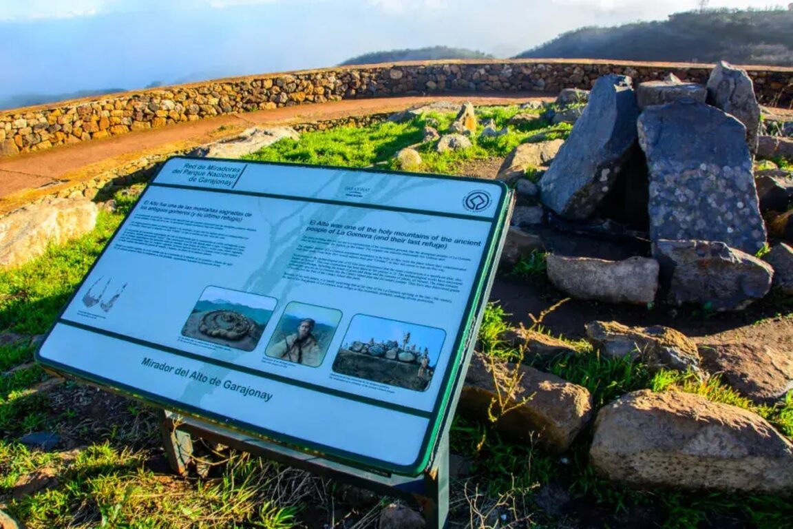
- The summit: Alto de Garajonay, 1,487 metres, the highest point on La Gomera, reached by Route 7 from El Contadero: 2.5 kilometres and about 90 minutes per the island’s official trail listing, with a pre-Hispanic ceremonial site on the summit plateau.
- Entry and booking: The park is free to enter and its trails need no ticket or permit. The park’s own guided walks are free too, but they are booked ahead through the visitor centres and the national parks reservation system.
- The centres: Juego de Bolas visitor centre at La Palmita, above Agulo, is open daily 9.30am to 4.30pm and free; the Laguna Grande information point keeps similar daytime hours. Start at one of them for trail conditions on the day.
- The weather rule: Trade winds push cloud against the high forest most days. The summit view is a morning prize, the forest is wet and cool in every month, and a waterproof layer and warm mid layer are standard kit, not winter extras.
- The bases: Vallehermoso and the northern valleys suit the El Cedro and Juego de Bolas side; San Sebastian suits the ferry and the eastern trailheads; Hermigua sits between the two. Pick one base and drive less.
What makes the Garajonay laurel forest different?
Garajonay is the best preserved large example of laurisilva, the humid subtropical laurel forest that covered much of southern Europe in the Tertiary period and then vanished from the continent as the climate changed. It survives here because the trade winds bank cloud against La Gomera’s high centre, and the forest harvests that mist, the famous horizontal rain, keeping the canopy green through a rainless summer. The National Parks Authority describes Garajonay as holding more than half of the mature laurel forest left in the whole Canary archipelago. On the trail that translates into a particular atmosphere: moss and lichen on every trunk, ferns at head height, tree heath growing to 20 metres, and a green half light that barely changes with the hour. It is also a working water system, not just scenery: the forest’s captured mist supplies most of the island’s springs, which is why the park rules about staying on marked paths and taking nothing are enforced with real seriousness.
The park reaches into all six of the island’s municipalities and climbs from about 800 metres to the summit, so a single day’s walking can cross several forest types: deep valley laurisilva around El Cedro, where the biggest laurels stand; fayal brezal, the myrtle and heath forest of the drier southern slopes around Laguna Grande; and the wind clipped summit heath on the way to the Alto. An August 2012 fire burned 747 hectares, close to a fifth of the park, and regeneration is part of what you walk through on the southern and summit routes, young fayal brezal reclaiming ground that was pine plantation within living memory.
How do you climb Alto de Garajonay, and how should it be paced?
Route 7, El Contadero to Alto de Garajonay and back, is the essential summit walk: 2.5 kilometres, about 90 minutes at the official estimate, and graded medium by the island’s official trail service. The path climbs gradually from the Contadero car park on the GM-2 ridge road through young fayal brezal, the restoration forest that replaced old pine plantations, with the views opening as you gain height. The summit plateau holds an excavated archaeological site, one of the main ceremonial places of the island’s pre-Hispanic inhabitants, and a viewpoint that on a clear day takes in Tenerife, La Palma and El Hierro. The descent follows the same path, which makes pacing simple: this is a morning walk, not a day.
Pace it against the cloud, not the clock. The trade wind mist typically builds through the late morning, so the summit attempt belongs early: park at El Contadero by 9am, climb steadily without long stops, take your time at the top while the view lasts, and be descending as the forest fills with cloud, which has its own beauty lower down. The longer summit approach is Route 17 from Pajarito, which strings the climb into a half day and pairs naturally with the Roques viewpoints on the GM-2. Either way, carry the warm layer for the top: at 1,487 metres in moving cloud, the summit is the coldest place on the island, whatever the beach below is doing. Walkers who enjoy this kind of short, steep, view first pacing will find the same rhythm in our Madonie Mountains trails adventure in Sicily.
Which laurel forest loops give the deepest forest?
El Cedro is the answer. The hamlet of El Cedro sits in a valley on the park’s northern side, reached by a signed detour from the ridge road, and the walking from it is the classic Garajonay: Route 2 descends through the Cedro ravine, under some of the tallest and oldest laurel forest in the park, to the small Ermita de Lourdes, a chapel founded in 1935 in a clearing deep in the woods. The ravine carries one of the island’s few permanent streams, and after wet weather its waterfall, the Chorro de Cedro, runs strongly. As a loop with the return climb, allow half a day and expect the effort to be in the ascent back out of the ravine, on damp stone and roots that stay slippery in every season. Trekking poles earn their place here more than anywhere else in the park.
The connoisseur’s full day is Route 18, the Gran Circular, at about 16 kilometres: it links Pajarito, the Alto de Garajonay, El Contadero, Las Mimbreras, the Chorros de Epina and El Cedro into one long circuit of everything the park contains. It is a route for fit walkers who start early, carry all their water, and accept that the last third is walked on tired legs. Splitting its best sections across two days, summit in the morning of day one and El Cedro on day two, gives most walkers a better experience than the single heroic lap. One practical note for drivers: in high summer, from mid July to mid September, car access to Las Mimbreras on the El Cedro side is by reservation only, so summer walkers should plan that trailhead in advance or start from El Contadero instead.
What are the easy and recovery walks?
Not every Garajonay day should be a climb, and the park is unusually generous with short walks. Laguna Grande I is the gentlest introduction: a circular, accessible trail of 0.7 kilometres and about 20 minutes through the fayal brezal around the park’s main recreation area, with interpretive panels and a viewpoint over the Fortaleza dome. Laguna Grande is also a trail hub, with Routes 3, 6 and 14 leaving the same clearing, so an easy morning can grow by one loop at a time as legs and weather allow. The Raso de la Bruma and Las Creces circuits on the western side give short, misty forest walks with almost no climbing, and the viewpoints along the GM-2, Los Roques above all, deliver the volcanic scenery for the price of a layby stop. Build the trip as hard, easy, hard: summit day, a Laguna Grande and visitor centre day with the Juego de Bolas exhibitions and gardens, then the El Cedro day. That alternation is what pacing means in a park where the walking is steep, damp and deceptively tiring.
Where should you base yourself, Vallehermoso or the south?
Vallehermoso, in the north west, is the walker’s base the board title promises: a working town under the Roque Cano pinnacle, closest to the Juego de Bolas visitor centre, the Agulo and Hermigua valleys and the El Cedro side of the park, with the island’s greenest scenery on its doorstep. Hermigua, in the next valley east, splits the difference, with quick access both to El Cedro and up the GM-2 to the summit trailheads. San Sebastian, the capital and ferry port on the east coast, has the most hotels and restaurants and the shortest drive to El Contadero, but the driest, least forested setting. Valle Gran Rey in the south west is the beach base, best for combining morning trails with afternoon swimming, at the price of the longest drive to the high forest. There is no wrong answer, but there is a wrong pattern: changing base every night on an island of hairpins. Choose one, learn its roads, and let the walks, not the luggage, fill the days. For a contrasting island forest trip built the same way, see our Pollino National Park trails adventure.
What should you carry, and what rules apply on the trails?
- Footwear: Waterproof hiking boots or shoes with a deep tread. Paths are damp year round, and the El Cedro descent is slippery stone and root in every month.
- Layers: A waterproof shell and a warm mid layer, carried always. The high forest sits in cloud at temperatures far below the coast, and the summit adds wind.
- Water and food: Carry all the water you need; there are no supplies on the trails. Laguna Grande has the park’s restaurant and picnic areas, and El Cedro hamlet has a small restaurant, but neither should be assumed open at your hour.
- Navigation: The numbered route network is waymarked, and the visitor centres give out route information. Download or carry the route for your walk anyway, because mist removes landmarks in minutes.
- Poles: Recommended for the El Cedro ravine and any descent after rain.
- Rules: Stay on marked paths, take all litter out, no camping or fires, and bicycles are not allowed on park trails. Trails and access points can close in high fire danger or after storms, so check at a visitor centre before setting out.
How do you get to La Gomera and fit the park into a trip?
La Gomera is reached by sea or by a small island airport. Fast ferries link Los Cristianos in Tenerife with San Sebastian de la Gomera in roughly an hour, which makes the park reachable as a long day trip from Tenerife, though it deserves better: two or three nights on the island turns Garajonay from a viewpoint drive into the walking trip described here. A workable shape is arrival day with the Laguna Grande circuit and the visitor centre, a summit morning followed by the Los Roques viewpoints and a Vallehermoso evening, an El Cedro day from a northern base, and departure after a final short walk. Keep one flexible half day in hand for weather, because the island’s one certainty is that the cloud will rearrange at least one plan, and the forest in full mist, dripping and silent, is not a consolation prize. It is half the point of coming.
Frequently Asked Questions
Do you need a permit or ticket for Garajonay National Park?
No. Entry to the park and its waymarked trail network is free, with no barrier controlled access and no permit for individual walkers. The park’s own guided walks are also free but must be booked ahead through the visitor centres or the national parks reservation system, and summer car access to Las Mimbreras is by reservation.
How long does the Alto de Garajonay climb take?
Route 7 from El Contadero is 2.5 kilometres and listed at about 90 minutes by the island’s official trail service, graded medium. Go early, because trade wind cloud usually builds through the late morning and the summit view at 1,487 metres is the prize. The longer Route 17 from Pajarito makes it a half day.
What is the best walk in Garajonay for deep laurel forest?
The El Cedro routes. Route 2 descends the Cedro ravine through the park’s tallest, oldest laurel forest to the Ermita de Lourdes chapel, with a stream and, after rain, a waterfall. Allow half a day for the loop, and expect a slippery descent and a steady climb back out.
When is the best time of year to walk in Garajonay?
The park is walkable all year, which is the advantage of the Canary climate, but the forest is wettest and the trails muddiest in winter, and fire danger can close paths in the driest summer weeks. Spring and autumn balance green forest, quieter trails and settled weather. In every month, carry a waterproof and a warm layer for the high forest.
Is Vallehermoso a good base for Garajonay?
Yes, for the northern park. Vallehermoso sits closest to the Juego de Bolas visitor centre, Agulo, Hermigua and the El Cedro trailheads, under the Roque Cano. San Sebastian suits the ferry and the eastern trailheads, and Valle Gran Rey suits walkers who want a beach beside the hiking. One base for the whole stay beats moving nightly.
Featured image: The Mirador del Alto de Garajonay, the summit viewpoint and pre-Hispanic stone circle at 1,487 metres, from the official La Gomera tourism site (lagomera.travel, Canaries destination platform), used with credit. Park figures, route distances and centre hours checked 17 November 2026 against the National Parks Authority (MITECO), the island’s official trail listings and UNESCO and UNEP park data.