 Omar Haddad
Pace the Madonie as a real mountain range that happens to sit behind the Sicilian coast, not as a scenic drive with walks attached. The range holds Pizzo Carbonara at 1,979 metres, the highest ground in Sicily after Mount Etna, and its signature day, the loop from Piano Battaglia at around 1,600 metres, is rated by the park for experienced hikers, crosses exposed karst with no shade and no water, and turns genuinely difficult when fog closes over the plateau. Around that demanding core sits a gentler Madonie that rewards pacing just as much. Beech forest loops, the giant holly grove at Piano Pomo, and village days in Castelbuono deliver the range at walking speed, provided they are given their own days rather than squeezed around the summit attempt. The plan below separates the two, assigns fitness honestly, and builds recovery into the trip instead of hoping tired legs recover on their own.
Quick Facts for Madonie Mountains Trails
- The park in one line: The Madonie Regional Park covers 39,941 hectares across 15 municipalities between the Imera and Pollina river valleys in northern Sicily, and forms part of the Madonie UNESCO Global Geopark.
- The high point: Pizzo Carbonara, 1,979 metres, the highest peak in Sicily after Mount Etna, reached by the official loop from Piano Battaglia.
- The signature route, honestly graded: The park official Pizzo Carbonara itinerary is a 7.2 kilometre loop from Piano Battaglia with about 379 metres of ascent and an indicated duration of four hours, rated EE, for experienced hikers. Fog is the named hazard, and the park recommends attempting it only in good visibility.
- The gentle counterweight: Piano Pomo, at about 1,400 metres above Castelbuono, holds a grove of around fifty giant hollies reaching some 15 metres tall and roughly 400 years old, reached by an easy nature trail from Piano Sempria and the Rifugio Crispi.
- Services reality: There is no water and no service network on the high trails. Everything for a summit day, water included, is carried from the trailhead.
- The base: Castelbuono for food, the Ventimiglia Castle and the Francesco Mina Palumbo naturalistic museum, plus access to Piano Pomo. The Petralia villages suit the Piano Battaglia side. One base, chosen well, beats nightly moves on mountain roads.
Where do Madonie trails actually start, and which base suits them?
Scale is the first thing to understand. At nearly 40,000 hectares, the Madonie is not one attraction but a mountain district, and its trailheads are separated by long, winding drives. Piano Battaglia, the high plateau and small ski station at around 1,600 metres above Petralia Sottana, is the start of the Carbonara loop and the natural focus for summit ambitions. Piano Sempria, above Castelbuono, is the start for Piano Pomo and the monumental tree country on the northern side of the Carbonara massif. Castelbuono itself, with its 14th century Ventimiglia Castle, its naturalistic museum covering Madonie flora, fauna and geology, and the strongest choice of places to eat in the park, is the base that makes the northern trails and a rest day work without a car marathon. Travellers who have walked Mount Etna will recognise the pattern of a high Sicilian mountain day, but the Madonie adds distance between trailheads that Etna, for all its scale, does not.
Choose the base by the main goal. A Carbonara attempt argues for Castelbuono or the Petralias with an early start and a short, committed drive to Piano Battaglia. A forest and village trip argues for Castelbuono alone, walking out to Piano Pomo and spending the saved energy in town. Trying to hold both ends of the park in one short stay is the classic Madonie mistake, and it is a driving mistake before it is a walking one.
How should the Pizzo Carbonara day be paced?
Treat the official loop as a full mountain commitment in a modest distance. The park route climbs from Piano Battaglia at around 1,600 metres to the 1,979 metre summit and back over 7.2 kilometres, with about 379 metres of ascent and an indicated four hours, and the park grades it EE, its experienced hiker category. The terrain explains the grade. The high Madonie is limestone karst, a bright, exposed plateau country of dolines, sinkholes and rough rock, with beech woodland on the approaches and open, shadeless ground above. There is nowhere to refill water, nowhere to shelter, and in fog the plateau features that make navigation straightforward in clear air disappear into a white, repetitive landscape. The park warning is explicit. Attempt the summit in good visibility and favourable weather, and treat a fogged in morning as a decision already made.
Pacing that respects the grade looks like this. Start early from Piano Battaglia, in the cool of the morning, with at least a litre of water per person and realistically more in warm months, layered clothing and a windproof jacket even when the coast below is in shirtsleeves. Walk the ascent steadily rather than quickly, because altitude, glare off pale limestone and rough footing tax legs out of proportion to the distance. Keep the summit stop short if cloud is building. The descent over loose karst is where tired walkers twist ankles, so the day is not finished at the top, and the schedule should say so. Fitness honesty matters here. A walker who is comfortable on graded E hiking trails, with a steady step on steep and rocky ground, is ready. A walker whose recent experience is coastal paths and town walking should build up through the forest routes first, or take a qualified local guide, which the park ecosystem supports and which first time visitors to this range are wise to use.
What do the beech forest and Piano Pomo days offer instead?
The Madonie below the summit plateau is forest country, and it is where most travellers will have their best days. Beech woods clothe the higher slopes, giving shaded loops that stay walkable in warm weather and glow in autumn, while the northern slopes above Castelbuono hold something rarer. At Piano Pomo, in a sheltered valley at about 1,400 metres on the north eastern side of the Carbonara massif, around fifty hollies have grown into a pure grove of monumental trees, some 15 metres tall, with circumferences around four metres and ages estimated at roughly 400 years. Holly elsewhere is a shrub of a few metres. Here, in deep siliceous soil and a favourable microclimate, it became a forest, and the grove is described as a living fragment of the flora that covered much of Europe before the ice ages. The nature trail from Piano Sempria, by the Rifugio Crispi, passes monumental oaks and maples on its way to the grove and its stone shepherd shelter, the pagghiaru, and it is graded for ordinary walkers. This is the Madonie day to schedule after the summit, or instead of it, with a picnic rhythm rather than a summit timetable.
Recovery pacing is a skill, not an indulgence. A sound three day pattern is a forest day first, to learn the range and test footwear on Madonie rock, the Carbonara loop second, started early and only in a clear forecast, and a Castelbuono day third, with the castle, the museum and a long lunch doing the restorative work. Castelbuono is a serious food town, home to the Fiasconaro panettone makers and to one of the last commercial harvests of manna, the sweet sap gathered from cultivated ash trees around Castelbuono and Pollina. Eating well is part of the recovery plan in the Madonie in a way it is not on every mountain trip, and a traveller following the packing logic in the Sicily packing guide will already have the layers this range demands in changeable weather.
What kit, booking and safety calls does a Madonie trip require?
Kit is simple and non negotiable. Trekking shoes or boots with a firm grip, worn in, because karst limestone is hard, sharp and slippery when wet. Water for the whole day, since the high trails have no supply. Sun protection, because the plateau offers no shade. Layers and a windproof shell, because 1,600 to 1,979 metres is a different climate from Cefalu at sea level, an hour away. Offline mapping or a paper map, because plateau fog removes visual references and phone coverage cannot be assumed. The park rules are equally plain. Stay on marked paths, do not pick flowers or remove natural material, take rubbish out, and keep noise low near grazing and wildlife areas.
Booking in the Madonie is mostly about timing and people rather than tickets. The high trails are open mountain routes without a permit system of the kind found on Etna summit zones, but conditions, trail status and any current restrictions should be checked with the park before a demanding walk, starting from the official route description for Pizzo Carbonara on the park website. Accommodation in Castelbuono and the Petralias is small scale and fills at weekends and in high season, so book the base before the routes. Guided walks with qualified local guides can be arranged from Castelbuono for the Carbonara loop and the monumental tree routes, and for walkers without mountain navigation experience a guide converts the park EE grade from a warning into a managed day. In winter, Piano Battaglia operates as a small ski area and the summit route can require winter equipment after snow, which is the final pacing lesson of this range. The Madonie is a four season mountain, and the season, not the calendar ambition, sets the programme. Side trips to the Aeolian Islands pair naturally with a Madonie stay through Cefalu, but they belong after the mountain days, not interleaved with them.
Frequently Asked Questions
How hard is the Pizzo Carbonara loop from Piano Battaglia?
Harder than its distance suggests. The park official route is 7.2 kilometres with about 379 metres of ascent and an indicated four hours, and the park rates it EE, for experienced hikers. Exposed karst, rough footing, no water and fog that can remove all visual references explain the grade. Walkers confident on graded hiking trails in clear weather are the right audience.
What is the best gentle walk in the Madonie?
The Piano Pomo nature trail from Piano Sempria above Castelbuono. It leads through monumental oaks and maples to a grove of around fifty giant hollies, some 15 metres tall and roughly 400 years old, at about 1,400 metres. It suits ordinary walkers, pairs with a Castelbuono afternoon, and shows the range forest character at its most unusual.
Where is the best base for Madonie trails?
Castelbuono for most travellers. It offers the Ventimiglia Castle, the Francesco Mina Palumbo naturalistic museum, the best food in the park and access to Piano Sempria and Piano Pomo, with Piano Battaglia reachable for an early summit start. The Petralia villages suit travellers focused entirely on the Piano Battaglia side.
Do Madonie trails need permits or booking?
The high routes are open mountain trails rather than a ticketed permit system, but the park advises checking current trail and regulatory information before a demanding walk, and the Carbonara route should only be attempted in good visibility. Book accommodation early in small villages, and book a qualified local guide in advance if you want one.
When is the best season for Madonie hiking?
Spring and autumn are the strongest seasons, with spring flowers, autumn beech colour and temperatures that suit full days outside. Summer is workable at altitude but demands early starts, serious water and sun discipline. In winter the high routes can be under snow, and Piano Battaglia turns to skiing.
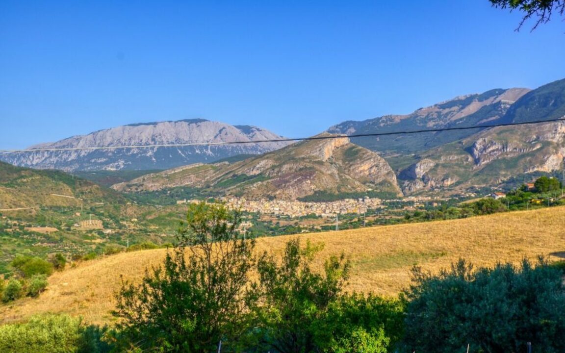
Prices and conditions checked 17 November 2026. Route figures are the Madonie park official Pizzo Carbonara itinerary as published by the park and summarised 17 November 2026. Featured image: green fields and limestone mountains of the Madonie near Castelbuono, Sicily. Photo by Antonio Sessa on Unsplash, Unsplash License.