 Sofia Rossi
Pace Pollino as a multi day mountain expedition based in one village, not as a single heroic summit day. This is the largest national park in Italy, 192,565 hectares straddling Basilicata and Calabria, and its high country is built around Serra Dolcedorme at 2,267 metres, the highest peak in the southern Apennines. The classic approach from Colle Impiso at 1,573 metres is a demanding round trip of seven to nine hours with well over 800 metres of climbing, across exposed limestone with no water, no shelter and weather that changes fast. Around that summit core, the park offers the walks that make a trip sustainable. Beech forest routes to Piano Gaudolino, stands of Bosnian pine on Serra di Crispo, known as the Garden of the Gods, and slow evenings in Rotonda, the park headquarters town, let fitness build and recover across several days. The travellers who enjoy Pollino most are the ones who arrive with a sequence, not a single target.
Quick Facts for Pollino National Park Trails
- The park in one line: Pollino National Park covers 192,565 hectares across 56 municipalities in Basilicata and Calabria, the largest national park in Italy, formally established by presidential decree on 15 November 1993, with headquarters in Rotonda and UNESCO Global Geopark status since 2015.
- The high point: Serra Dolcedorme, 2,267 metres, the highest peak in the southern Apennines, with Monte Pollino at 2,248 metres and Serra del Prete at 2,181 metres completing a trio of summits above 2,100 metres.
- The signature route, honestly graded: From Colle Impiso at about 1,573 metres, Serra Dolcedorme is usually planned as a seven to nine hour round trip with elevation gain exceeding 800 to 1,000 metres depending on the variant. The combined Monte Pollino and Dolcedorme loop runs about 17.3 kilometres and around seven and a half hours. Both are difficult routes for very fit, sure footed walkers.
- The symbol in the landscape: The Bosnian pine, pino loricato in Italian, grows on exposed limestone roughly between 1,000 and 2,200 metres. One Pollino specimen, named Italus, has been dated at about 1,230 years old, among the oldest scientifically dated trees in Europe.
- Access reality: General hiking trails in the park carry no entrance fee or permit system. What they require instead is self reliance, a car to reach trailheads such as Colle Impiso, and current information from the park and its official guides.
- The base: Rotonda on the Basilicata side, home to the park authority and its ecomuseum, for the Colle Impiso and Piano Ruggio side. Castrovillari and Morano Calabro serve the Calabrian approaches. Pick one base and keep it for the whole stay.
Why does Pollino demand a sequence rather than a single summit day?
Distance and emptiness define this park. At 192,565 hectares, Pollino is not a compact reserve with a visitor centre and a loop trail. It is a mountain region, stretching from the Tyrrhenian side to the Ionian side, with villages inside its boundary and trailheads separated by long mountain drives. Colle Impiso, the standard start for the high summits, sits at about 1,573 metres at the end of a winding road above the Frido valley. A Dolcedorme day that starts there, climbs through the Piani del Pollino and the Canale del Malevento to the summit ridge, and returns safely is a seven to nine hour undertaking before the drive back to the base is counted. Walkers who attempt it on their first day, on legs fresh from a flight and a motorway, are the ones who turn a magnificent route into an ordeal.
A sequence fixes that. A first day in the beech forests, for example the forest route from Colle Impiso towards Piano Gaudolino, teaches the terrain, the waymarking and the altitude at a forgiving grade. A second day can target the Bosnian pine country, walking towards Serra di Crispo and its Garden of the Gods, where the pines stand on the ridge in the shapes the wind has given them. Only then does the Dolcedorme day arrive, with legs adjusted, footwear proven and a forecast chosen rather than inherited. That order, forest, pine ridge, summit, is the pacing this article recommends, and it mirrors how the park itself is layered, from chestnut and beech lowlands up through pine to bare limestone. Travellers coming from a Matera stay in Basilicata will find Rotonda a logical next base, with the same region offering a complete change of altitude and pace.
How should the Serra Dolcedorme day itself be paced?
Start from Colle Impiso before the day warms, with every litre of water the day requires, because the high route offers no reliable refill. The way climbs past the Gaudolino area and across the high plateaus of the Piani del Pollino, open grassland where cattle and horses graze in season, before the route commits to the Malevento channel and the final climb to the 2,267 metre summit. On a very clear day the summit repays everything, with views that can take in both the Tyrrhenian and Ionian seas, the Sibari plain below and the full arc of the Pollino massif, Monte Pollino and Serra del Prete included. Build the turnaround discipline in advance. Cloud building over the massif, wind rising on the ridge or a party member slowing sharply are all reasons to descend, and the limestone plateau in poor visibility is no place to improvise a route.
Fitness needs stating plainly. Dolcedorme from Colle Impiso, and still more the combined loop that adds Monte Pollino for about 17.3 kilometres and around seven and a half hours, are difficult routes. They suit walkers with recent full day mountain experience, sure footing on loose and rocky ground, and the aerobic base for a thousand metres of climbing at altitude. They do not suit a first ever mountain day, however enthusiastic. The honest alternatives inside the same park are excellent rather than consolation prizes. Piano Ruggio, a high plateau reached from the Rotonda side, offers shorter walks and wide views with far less commitment, and the beech forests, including old growth stands recognised within the UNESCO ancient beech forests listing at Cozzo Ferriero and Pollinello, give shaded, restorative walking on the days around a summit attempt.
What makes the Bosnian pine country worth its own day?
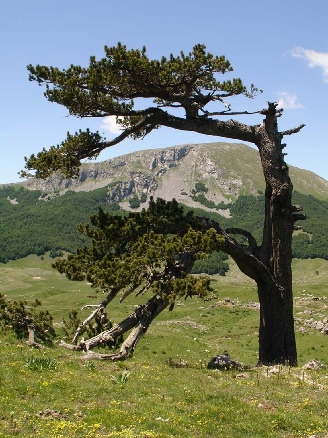
No other Italian landscape looks like the high Pollino ridges, and the reason is a tree. The Bosnian pine, Pinus heldreichii, called pino loricato for bark that plates like Roman armour, survives where almost nothing else can, on exposed limestone ridges roughly between 1,000 and 2,200 metres, shaped by wind, frost and lightning into twisted, sculptural forms. It is the symbol of the park, printed on its materials and standing over its best viewpoints, on Serra di Crispo, along the approaches to Dolcedorme and around the Piani del Pollino. The species is a relict, a survivor from a colder Europe, and Pollino holds its most famous individual. Italus, a Bosnian pine growing in the park, has been scientifically dated at about 1,230 years old, which makes it one of the oldest dated trees in Europe. Walking among these pines at a slow pace, with time to stop, is a different experience from passing them at summit speed, and it is why the pine ridge deserves a day of its own in the sequence.
That slow day is also the recovery day, and Pollino bases support it well. Rotonda, where the park authority has its headquarters in the monumental complex of Santa Maria della Consolazione, holds the park ecomuseum and a food culture built on two protected products, the white bean of Rotonda DOP and the red aubergine of Rotonda DOP, a small round aubergine unlike the elongated kind found elsewhere. Evenings of beans, local cheese and village quiet are the correct recovery protocol after high limestone days, and they cost a fraction of the effort of another summit. A traveller extending a southern Italy trip northwards can pair Pollino with Orvieto only with real driving time allowed, which underlines the point. Pollino is a destination to settle into, not a stop to squeeze.
What booking, kit and safety calls does a Pollino trip require?
Booking here means people and information rather than tickets. General trails in Pollino National Park are free to access with no permit system, a fact worth confirming against current park communications before travel, along with trail conditions, refuge status and any local restrictions, particularly around the Raganello gorges near Civita, where access rules are strict after fatal flash flooding in 2018 and sections require authorised guides. For the high routes, the park association of official guides is the key resource. A certified park guide brings route knowledge in a landscape where waymarking varies, weather judgement on an exposed massif, and the pacing discipline this article describes, and for a first Dolcedorme attempt a guide is the single best investment in the trip. Refuges require checking rather than assuming. The Rifugio Pino Loricato by the Sanctuary of the Madonna del Pollino has been reported under renovation with overnight stays unavailable, so verify current status before building a plan around any refuge bed.
Kit follows from the terrain. Boots with ankle support and grip for limestone, scree and plateau grass. Water for the full day, carried. Sun protection for treeless high country. Layers and a windproof and waterproof shell, because a massif that holds snow into spring and generates its own weather cannot be trusted to a valley forecast. Offline maps, since coverage fades across much of the park, and a headtorch, because a seven to nine hour day that starts late or slows down ends in the dark. The best trekking months are May and June and September and October, when the high country is generally clear of snow, the heat is manageable and the beech forests are at their best. Summer summit days are possible with very early starts and serious water. Winter transforms the high Pollino into snow country suited to snowshoeing on the plateaus rather than summit attempts by ordinary walkers. Choose the season, choose the sequence, and Pollino gives back one of the great mountain weeks in Italy.
Frequently Asked Questions
How long does it take to climb Serra Dolcedorme?
Plan seven to nine hours for the round trip from Colle Impiso at about 1,573 metres, with elevation gain exceeding 800 to 1,000 metres depending on the variant taken. The combined loop adding Monte Pollino covers about 17.3 kilometres in around seven and a half hours of walking. Both are difficult routes for fit, experienced mountain walkers.
Do you need a permit or a ticket for Pollino National Park trails?
No general entrance fee or permit applies to the park hiking trails. The exceptions to research are specific regulated places, notably parts of the Raganello gorges, where access is controlled and authorised guides are required. Check current park communications before travel, and consider a certified park guide for any high summit route.
Where is the best base for Pollino trails?
Rotonda for the Basilicata side. It is the park headquarters town, with the park ecomuseum, and it serves Colle Impiso, Piano Ruggio and the Madonna del Pollino sanctuary area. Castrovillari and Morano Calabro are the practical bases for Calabrian approaches. Stay in one base for the whole trip, because trailheads are far apart.
What is the Bosnian pine and where can it be seen?
The Bosnian pine, pino loricato, is the park symbol, a relict pine with armour plated bark that grows on exposed limestone roughly between 1,000 and 2,200 metres. See it on Serra di Crispo, the Garden of the Gods, around the Piani del Pollino and on the Dolcedorme approaches. The park also holds Italus, a specimen dated at about 1,230 years old.
When is the best time to hike in Pollino?
May to June and September to October are the most versatile trekking periods, with the high routes generally free of snow and temperatures suited to full days. Summer demands very early starts and extra water. Snow can linger on the high massif into May, and winter is snowshoe season on the plateaus rather than summit season.
Prices and conditions checked 17 November 2026. Park area, establishment and summit figures are Pollino National Park authority figures as published and summarised 17 November 2026. Featured image: a Bosnian pine, pino loricato, above beech forest and limestone peaks in Pollino National Park. Photo from Pollino National Park official website, parconazionalepollino.it, used with credit.