 River Callahan
The Needles is the Canyonlands district most visitors never reach, and the reason is simple geography: it sits in the park’s southeast corner, at the end of a long paved road, with no connection to the famous mesa top viewpoints near Moab. That distance is the gift. Come here for the Chesler Park trail from Elephant Hill, where a grassland bowl ringed by banded sandstone spires delivers the single best walk in Canyonlands, and for Newspaper Rock on the drive in, a panel of petroglyphs beside the road that most visitors drive straight past.
Quick Facts
- Entrance: $30 per private vehicle for 7 days, $25 per motorcycle and $15 per person on foot or bicycle, per the National Park Service Canyonlands fees page. The park annual pass is $55.
- Access: US 191, 40 miles south of Moab, then UT 211 west for about 35 miles, per NPS. UT 211 is the only paved road in and out.
- Chesler Park Viewpoint: 5.8 miles round trip, 3 to 4 hours, per the NPS Needles trails guide.
- Chesler Park Loop and Joint Trail: 10.7 miles round trip, 5 to 7 hours, per NPS.
- Named for: The colourful spires of Cedar Mesa Sandstone that dominate the district, per NPS.
- Water: Available year round at the Needles Visitor Center, per NPS. There is no water on the trails.
The Trailhead Most Visitors Miss
Here is the district’s quiet secret, hidden in plain sight on the map. Almost every Needles headline hike, Chesler Park, the Joint Trail and Druid Arch among them, starts not at the visitor centre and not at the campground, but at Elephant Hill, at the end of the maintained road beyond the campground. Visitors who stop at the scenic drive pullouts, walk a short nature trail and leave have seen the district’s frame but not its picture. Elephant Hill trailhead is where the Needles actually begins, and the parking area there is the trailhead most visitors miss entirely, because reaching it requires committing to the far end of the road and to a real walk.
The name Elephant Hill also belongs to the four wheel drive road that climbs from that trailhead, one of the most demanding in the national park system, and day use permits are required for vehicles on the Elephant Hill road. Hikers need no such permit for a day walk, which makes the walking version of this country the simpler bargain: park, fill water bottles, and follow cairns into Elephant Canyon.
Chesler Park: The Walk That Justifies the Drive
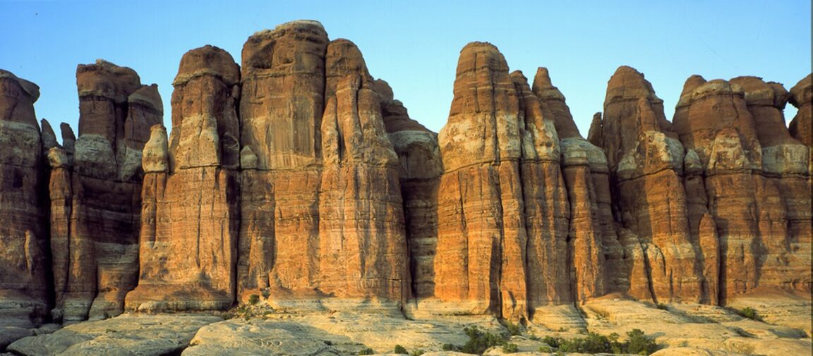
From Elephant Hill, the trail drops into Elephant Canyon, climbs through a landscape of banded red and white spires, and reaches a saddle with the first full view over Chesler Park. The viewpoint alone, at 5.8 miles round trip and 3 to 4 hours according to the NPS Needles trails and roads guide, is a complete and satisfying hike. Chesler Park itself is the surprise at the centre of all this rock: a broad, open bowl of desert grassland, ringed almost entirely by the spires that give the district its name. In a park system full of canyon rims and viewpoints, Chesler Park is a place you stand inside, surrounded.
Strong hikers should continue. The full Chesler Park Loop with the Joint Trail runs 10.7 miles round trip and takes 5 to 7 hours, per NPS, and adds the district’s strangest passage: the Joint Trail threads a series of deep, narrow fractures in the sandstone, in places barely shoulder width, cool and shadowed even when the slickrock above is baking. The loop returns across the park’s grassland with the spires changing colour as the light moves. Start at dawn in warm months, carry every drop of water you will need, and treat the NPS time range as honest. There is no shortcut out of Chesler Park.
Newspaper Rock: The Stop on the Way In
About halfway along UT 211, before the park boundary, Newspaper Rock State Historic Monument protects one of the finest petroglyph panels in the Southwest, a dark varnished rock face dense with hundreds of carved figures: animals, human forms, tracks and symbols accumulated over centuries. It is a short, level stop of ten or twenty minutes, signed from the highway, and it reframes the whole day. The Needles trails pass ancestral sites and the district’s backcountry is rich in archaeology, and Newspaper Rock is the accessible introduction to that human depth. Look, photograph, touch nothing. The oils in skin damage petroglyphs, and the panel’s survival depends on visitors keeping their hands and their drones to themselves.
How the District Is Laid Out
The Needles forms the southeast corner of Canyonlands and was named for the colourful spires of Cedar Mesa Sandstone that dominate the area, as NPS puts it. Foot trails and four wheel drive roads lead to Tower Ruin, Confluence Overlook, Elephant Hill, the Joint Trail and Chesler Park. The visitor centre is open daily from spring through fall, with hours varying by season, and it is the district’s year round water source, its permit desk for backcountry trips and its best source of same day trail conditions. The campground near the trailheads fills early in spring and autumn. Unlike Island in the Sky, where the rewards sit at the ends of short paved spurs, the Needles pays out on foot, over distance, which is precisely why its trails stay quiet while Moab’s famous viewpoints queue.
NPS also issues a warning worth obeying literally: use a map to reach the Needles, because GPS units frequently lead people astray in this country. The route is simple, US 191 to UT 211 and then west to the road’s end, but services are not. There is no fuel, food or lodging in the district, and cell coverage is unreliable. Arrive with a full tank, a full stomach’s worth of supplies and a downloaded or paper map, and the remoteness becomes the pleasure it is supposed to be.
Pairing the Needles With the Rest of Canyon Country
Give the Needles its own full day and resist bolting it onto an Island in the Sky morning; the districts share a name and a fee, not a road. On neighbouring days, our plain language explainer on Arches National Park timed entry in 2026 will keep a Moab base running smoothly, and our first timer’s guide to Capitol Reef, Fruita’s orchards and Hickman Bridge extends the same red rock logic west along the Utah parks route. Read together, the three districts and parks make a coherent week: mesa top spectacle at Island in the Sky, immersion on foot in the Needles, and orchard shade in Fruita when desert legs need a gentler day.
Frequently Asked Questions
How much does Canyonlands cost to enter?
The standard pass is $30 per private vehicle, $25 per motorcycle or $15 per person entering on foot or by bicycle, valid for 7 days, per NPS. A $55 annual pass covers Arches and Canyonlands plus Natural Bridges and Hovenweep, and America the Beautiful passes are accepted.
How do I get to the Needles District?
Drive US 191 for 40 miles south of Moab, or 14 miles north of Monticello, then take UT 211 west for roughly 35 miles to its end in the Needles, per NPS. It is the only paved road in or out, and NPS advises using a map rather than trusting GPS.
How long is the Chesler Park hike?
The Chesler Park Viewpoint is 5.8 miles round trip and takes 3 to 4 hours. The full Chesler Park Loop with the Joint Trail is 10.7 miles round trip and takes 5 to 7 hours, per the NPS trails guide. Both start at the Elephant Hill trailhead.
Do I need a permit to hike to Chesler Park?
No permit is needed for day hiking. Permits are required for overnight backcountry trips and for driving the four wheel drive roads such as Elephant Hill, and those are arranged through the park and Recreation.gov. Check current requirements with NPS before travelling.
Is there water in the Needles District?
Water is available year round at the Needles Visitor Center, per NPS, and nowhere on the trails. Fill up before Elephant Hill and carry all the water your hike requires; desert mileage here is fully exposed.
What is Newspaper Rock and where is it?
Newspaper Rock is a major petroglyph panel protected as a state historic monument along UT 211, on the drive into the Needles. It is a short roadside stop before the park entrance, and visitors should view and photograph it without touching the rock face.
Featured image: The Needles, Canyonlands National Park, Utah. Photo: National Park Service, via nps.gov, the park’s official website, public domain basis, used with credit.