 Kwame Mensah
The Tongariro Alpine Crossing is a one way, 20.2 km alpine walk from Mangatepopo to Ketetahi that has to be organised backwards: book the free DOC track booking and the shuttle first, watch the Red Crater weather forecast and the 6 am advisory, and only then commit to the day. The walk climbs from 1,120 m to the 1,886 m summit of Red Crater, drops down loose scree to the Emerald Lakes, passes Blue Lake, and then descends for hours to the Ketetahi road end at 760 m. Fit, prepared walkers in summer conditions should plan on a full day of seven to nine hours, and nobody should plan on parking a car at either end and walking back to it.
Everything below follows the Department of Conservation guidance for the track, checked on 18 November 2026, including the changes after the 2025 fires in Tongariro National Park.
Quick Facts
- Distance and direction: 20.2 km one way, walked from the Mangatepopo road end to the Ketetahi road end, with a total elevation change of plus or minus 1,196 m.
- High point: Red Crater at 1,886 m. The track starts at 1,120 m and finishes at 760 m.
- Booking: DOC recommends a track booking for all visitors, and a booking is required to use a shuttle or guided walk service. There is no cost to book.
- Parking: Four hour maximum parking restrictions apply at the road ends in the main season, which runs from Labour weekend in late October to 30 April, so DOC advises booking a shuttle.
- Seasons: The late October to April season is graded intermediate. From May to October the track is an expert winter route with snow, ice and avalanche risk, where alpine skills are essential and going with a guide is the DOC recommendation.
- Weather rule: In summer DOC applies a Not Recommended Today advisory, assessed at 6 am, when forecast thresholds for wind, wind chill, rain or snow at Red Crater are breached.
- Respect the place: The lakes are sacred and must not be touched or entered, walkers must stay on the marked track, and a 10 year restorative rahui covers the fire affected area near the start after the late 2025 fires.
Why does the shuttle decide the whole day?
The Crossing does not loop. The start and finish are on different sides of the mountain, the walk takes most of a day, and the parking rules are set well below the time the walk requires. DOC lists four hour maximum parking restrictions at the road ends through the main season and advises walkers to book a shuttle instead. In summer there is effectively no parking solution for a Crossing walker at the Mangatepopo end, so the shuttle is not a convenience layered on top of the walk. It is the mechanism that makes the walk possible.
The standard pattern is a morning drop at Mangatepopo and an afternoon collection at Ketetahi, with operators running from National Park Village, Whakapapa, Turangi, Taupo and other nearby towns. Book the shuttle before the trip rather than on arrival in peak season, confirm the last Ketetahi pickup time in writing, and pace the day against that pickup rather than against sunset. The alternative pattern, parking at a private car park near the Ketetahi end and riding a morning shuttle to the start, puts your own car at the finish and removes the last bus anxiety, at the cost of an early drive. Either way, the DOC track booking comes first, because shuttle and guide services require their passengers to hold one.
Base choice matters to the shuttle timetable. Taupo gives the widest choice of operators and the longest transfer, National Park Village and Whakapapa give the shortest. Walkers building a few days around the lake should read our 3 days in Taupo guide, including the Tongariro decision, before fixing a base, and anyone arriving from overseas should settle entry paperwork early with our explainer on New Zealand’s NZeTA and visitor levy.
What happens on the track, section by section?
The first 5.4 km follow a well formed track and boardwalk up the Mangatepopo Valley, sharing the route with the Soda Springs Walk. This is the gentlest walking of the day and the right place to settle pace, layers and water. It is also the decision point DOC itself points to: the Soda Springs return is an easy two hour option for anyone who realises early that the full Crossing is beyond the day, their fitness or the weather.
At the head of the valley the climb steepens into a staircase ascent of around 350 m to the plateau of South Crater. From South Crater the track climbs again to Red Crater at 1,886 m, the highest point of the Crossing and the most exposed ground on the route. There is no shelter up here, the wind that the advisory thresholds are built around is a physical presence rather than a forecast number, and the correct response to deteriorating weather at South Crater is to turn back while the descent is still the staircase rather than the scree.
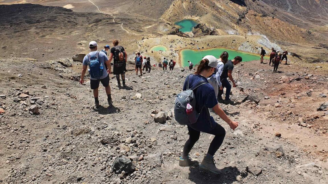
The descent from Red Crater to the Emerald Lakes is the technical heart of the walk: a steep slope of loose volcanic scree where DOC warns that loose rocks present a major slip hazard and advises extra time and care. Walk it slowly, in a zigzag, with poles if you use them, and expect it to cost more time than its short distance suggests. Below the lakes the track passes Blue Lake and begins the long northern descent, a zigzag of many steps that DOC notes can trouble weaker knees, before dropping through forest to the Ketetahi road end at 760 m. Toilets are spaced every one to two hours along the track, but there is no drinking water supply to rely on, so carry the day’s water from the start.
How does the summit weather system work?
DOC runs a hazardous weather advisory for the summer season, assessed at 6 am each day against the NIWA forecast for Red Crater. A Not Recommended Today advisory is applied if, in any two hour window between 9 am and 5 pm, the forecast breaches thresholds that include average wind of 55 kph or more, gusts of 70 kph or more, wind chill of minus 10 degrees C or colder, wind chill of 0 degrees C or colder combined with precipitation, a rain rate of 2.5 mm per hour or more, or 10 mm or more of precipitation across six hours. When the advisory is applied, signage goes up at Mangatepopo and operators and visitor centres are notified automatically.
Two limits of that system deserve emphasis. First, an advisory free morning is not a promise: DOC stresses that very cold temperatures, strong wind, heavy rain and poor visibility are common even in summer, and snow can fall at any time of year. Second, no advisories are issued from May to October at all, which is one reason the winter season is graded expert. In winter the forecast reading, avalanche awareness, crampons, ice axe skills and route finding in snow are the walker’s own responsibility, and DOC’s position is that alpine skills are essential and the track is best done with a guide in that season.
The volcanic setting adds a background risk that weather does not capture. The Crossing traverses an active volcanic area, geothermal steam vents near the Emerald Lakes can cause severe burns, and the lakes themselves are sacred to Ngati Hikairo ki Tongariro: do not touch, enter or eat beside them, and stay on the marked track at all times. After the two fires in late 2025, a 10 year restorative rahui sits over the affected area near the start of the track. Respecting it is simple and non negotiable: stay on the track, do not enter fire affected areas, clean shoes and gear before visiting, and take all rubbish out.
Are you fit enough, and how should you pace it?
DOC rates the fitness required as high, describes the track as steep and undulating over open, exposed and uneven ground, and does not recommend it for children under 10. A realistic self test is whether you can walk uphill for two sustained hours, descend steps for two more, and still be moving carefully at hour seven. Train for the descent as much as the climb, because the Ketetahi side is where tired knees and the shuttle deadline collide.
Pace the day in three blocks. Reach South Crater with energy in reserve and treat that as the go or no go gate for the summit ridge. Cross Red Crater and the scree slowly enough to arrive at the Emerald Lakes steady, because rushing the scree is how ankles are lost. Then protect the long descent: the zigzags to Ketetahi take hours, not minutes, and the walkers who miss pickups are usually the ones who celebrated at Blue Lake. Carry layers for a summit that can be near freezing in wind while the valley is warm, waterproofs regardless of the morning sky, sun protection for unshaded volcanic ground, and more water and food than a walk of this distance usually prompts. If conditions close in, DOC’s suggested alternatives, the Taranaki Falls track and the Tama Lakes track, deliver a serious Tongariro day without the exposed ridge, and walkers heading north afterwards can pair them with the geothermal and cultural day in our Rotorua Maori culture guide.
Frequently asked questions
Do I need to book the Tongariro Alpine Crossing?
DOC recommends a booking for everyone using any part of the track, and a booking is required if you use a shuttle or a guided walk. The booking is made through DOC and there is no cost to book.
Can I drive myself and park at the start?
Not realistically in the main season. Parking at the road ends is limited to four hours, far less than the walk takes, and DOC advises booking a shuttle. A private car park option near the Ketetahi end, combined with a morning shuttle to the start, is the workable self drive pattern.
How long does the Crossing take?
Plan a full day. DOC guidance puts the summer walk at roughly seven to eight hours for prepared walkers, and slower parties, winter conditions and long photo stops push it toward nine. Pace against the last Ketetahi shuttle pickup, not against daylight alone.
When is a guide required?
From May to October the track becomes an expert winter route with snow, ice, avalanche terrain and sub zero temperatures. DOC says alpine skills and equipment are essential in that season and that the track is best done with a guide. In summer a guide is a choice, not a requirement, for experienced and prepared walkers.
What weather should make me cancel?
A Not Recommended Today advisory is the clearest signal: it is triggered by forecast wind, gusts, wind chill, rain or snow at Red Crater breaching DOC thresholds. Even without an advisory, strong wind on the ridge, poor visibility or heavy rain are sound reasons to take the Soda Springs or Taranaki Falls alternatives instead.
Can I swim in the Emerald Lakes or Blue Lake?
No. The lakes are sacred to Ngati Hikairo ki Tongariro, and DOC asks walkers not to touch or enter them. Stay on the marked track, keep clear of steam vents, and treat the whole crater area as a place you pass through with care.
Track facts, distances, elevations, booking and parking rules and weather advisory thresholds checked on 18 November 2026 on the Department of Conservation’s Tongariro Alpine Crossing pages at doc.govt.nz. Conditions change daily, so recheck the DOC page and the NIWA Red Crater forecast on the morning of any walk.