 Wei Chen
The Kallur Lighthouse hike is won or lost before you set foot on Kalsoy. The island is reached only by the small car ferry from Klaksvik, the boat carries just 12 cars, and summer sailings sell out, so the ferry booking is the first decision of the day, not an afterthought. Book a vehicle space in advance through Strandfaraskip Landsins, the Faroese transport authority, or travel as a foot passenger and let the island bus do the driving. From the ferry landing at Sydradalur, a 17 km road through four tunnels runs north to Trollanes, the village at the end of the road. The lighthouse walk starts there: about 4 km return, roughly 400 metres of climbing, a mandatory hiking fee of 200 DKK per adult, and one and a half to two hours of walking to a small red and white lighthouse on one of the great cliff edges of the North Atlantic. Add the Seal Woman statue at Mikladalur on the drive back south and you have the complete Kalsoy day, sequenced properly.
Quick Facts
- The only way in: Ferry route 56 from Klaksvik to Sydradalur on Kalsoy, about 20 minutes, operated by Strandfaraskip Landsins (SSL). Book in advance at ssl.fo in season
- Ferry capacity: The vessel Sam carries only 12 cars. Foot passengers have a far easier time of it, and bus route 506 connects with the ferry on Kalsoy
- The drive: 17 km from Sydradalur to Trollanes through four single track tunnels. Parking at Trollanes is limited, which is why the official advice favours the bus
- The hike: Trollanes to Kallur Lighthouse, about 4 km return with roughly 400 metres of climbing, typically one and a half to two hours return
- Hiking fee: 200 DKK per adult, 100 DKK for ages 13 to 17, free for children under 13. Buy the pass online at hiking.fo or pay on arrival. The fee funds trail maintenance and visitor facilities
- The lighthouse: Kallur Lighthouse, built in 1927, a small white tower with a red band standing on the northern tip of Kalsoy above Trollanes
- The pairing: Kopakonan, the Seal Woman statue, stands on the shore at Mikladalur, the village south of Trollanes on the same road
- Screen fame: Kalsoy and the Kallur headland feature in the James Bond film No Time to Die, and a memorial gravestone to Bond stands near the lighthouse path
- Weather rule: Do not attempt the ridge in strong wind, heavy rain, thick fog, snow or ice. The final viewpoint ridge is narrow and exposed, with steep drops
Why does the ferry booking decide the whole day?
Because Kalsoy has no bridge, no tunnel and no second route in. Every visitor, every car and every bus passenger arrives on the same small ferry from Klaksvik, and the boat’s vehicle deck holds just 12 cars. In summer, and on any fine weekend, the car spaces go first, and the queue at Klaksvik harbour starts forming long before departure. Strandfaraskip Landsins, which runs the route as service 56, takes advance bookings, and Visit North, the regional tourism authority, advises reserving in advance through SSL during the summer season as a matter of course.
The smarter play for most hikers is to leave the car on the mainland altogether. Park in Klaksvik, walk on as a foot passenger, and take bus route 506 from Sydradalur, which is timed to connect with the ferry and runs the length of the island to Trollanes. That removes the vehicle lottery, removes the stress of the narrow tunnels, and guarantees your return is a timetable question rather than a deck space question. If you do bring a car, book both directions, not just the outbound sailing, and build your lighthouse walk backwards from your return ferry time. Missing the last boat means a night on Kalsoy you did not plan for.
However you cross, treat the ferry timetable as the frame of the day. The crossing itself takes about 20 minutes, the drive or bus ride north takes the best part of an hour with tunnel waits, and the hike needs two hours plus photography time. A mid morning sailing out and a late afternoon sailing back is the comfortable shape. Anything tighter turns the lighthouse into a rush, and this is not a ridge to hurry on. For the wider island context before you go, start with our Faroe Islands travel guide.
What is the drive from Sydradalur to Trollanes actually like?
It is one of the great small drives of the North Atlantic, and it sets the tone for the island. The road runs 17 km north from the ferry landing through four tunnels, each of them narrow and unlit, linking the island’s four villages in a line: Sydradalur, Hesar, Mikladalur and finally Trollanes. Kalsoy is long, thin and mountainous, with 13 peaks along its spine and the highest, Nestindar, rising 787 metres straight out of the sea. The road clings to the eastern shore, with Kunoy island across the water and waterfalls dropping off the slopes above you.
Two practical points shape the drive. First, parking at Trollanes is genuinely limited, and the village is tiny, which is exactly why the official guidance from Visit Faroe Islands recommends the bus over a car for this trip. Second, the villages repay a stop rather than a blur. Hesar and Mikladalur are working Faroese villages of turf roofed houses and small harbours, and Mikladalur holds the island’s second essential sight, the Seal Woman, which is best sequenced on the way back south when the light is often kinder and the lighthouse is already in the bag.
How does the Kallur Lighthouse hike itself work?
The trailhead is at Trollanes, the northernmost village on Kalsoy. Pay the hiking fee, 200 DKK for adults, either online in advance at hiking.fo or on arrival, and follow the clear path out of the village and up across grassy slopes. Visit North describes a clear trail across grassy hills, about 4 km for the return trip with roughly 400 metres of climbing, and most hikers complete it in one and a half to two hours. The going is grass, mud and sheep pasture rather than built path, and after rain it is slippery, which is why sturdy boots are the official advice rather than a suggestion.
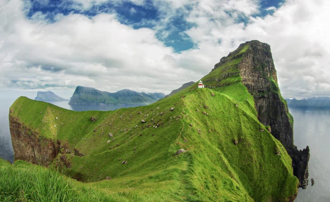
The lighthouse, when you reach it, is almost comically small for its fame: a modest white tower with a red horizontal band, built in 1927, standing on a grassy promontory at the very tip of the island. The building is not the point. The setting is. Behind it rises the fin of Borgarin, 537 metres of near vertical grass and rock, and from the lighthouse the views run to Kunoy, Eysturoy and Vidoy, with the sea stacks Risin og Kellingin, the Giant and the Witch, visible on the horizon in clear weather. A short walk beyond the lighthouse, along a narrow strip of land, gives the famous photograph: the little lighthouse in the foreground and the great cliff of Kallur falling away behind it.
That final ridge is also the serious part of the day. It is narrow, exposed and flanked by steep drops, and the official guidance is unambiguous: stay on the marked trail, keep a safe distance from cliff edges, and do not attempt the hike in strong wind, heavy rain, thick fog, snow or icy conditions. People underestimate Faroese weather because the walk is short. The wind on that ridge is the real climb. If conditions are wrong, the correct decision is the village, the statue and the ferry home, with the lighthouse left for another day. Walkers who like their coastal hikes with the same exposure honestly labelled will recognise the judgement calls in our Lofoten Islands travel guide.
Who is the Seal Woman of Mikladalur?
On the shore below Mikladalur stands Kopakonan, the Seal Woman, a bronze statue of a woman stepping out of a sealskin, gazing back towards the village. She illustrates the best known selkie legend in the Faroes. The story tells of seals who come ashore on the night of the Twelfth Night, shed their skins and dance as humans until dawn. A young farmer from Mikladalur stole the skin of one seal woman, trapping her in human form, and married her. She lived with him and bore his children, always searching for her hidden skin. When she finally found it, she returned to the sea, and the legend follows the curse she laid on the men of Mikladalur and the tragedy that followed when the village men went to hunt seals in the cave she had begged them to spare.
The statue is a short walk down from the village to the shore, and in rough weather the waves break dramatically around the rocks below it. Sequence it after the lighthouse rather than before. It needs no booking, no fee and no fitness, it fills the hour before your return ferry beautifully, and it gives the day its second, quieter register: folklore and village life after the morning’s cliff edge exertion. Together, the lighthouse and the Seal Woman are the reason Kalsoy, an island of a few dozen residents, carries an outsized share of the Faroes’ visitor imagination.
What fitness and kit does the hike honestly need?
This is a short hike with a serious setting, and it should be graded that way. The distance is only about 4 km return, but the roughly 400 metres of climbing is concentrated and grassy, the path can be muddy and slick, and the exposure near the lighthouse demands steady footing and a calm head for heights. A normally fit walker in proper boots will manage it comfortably inside two hours. Trainers, a hangover or a determination to reach the far ridge viewpoint in a gale are the usual ingredients in the stories that end badly.
Kit is simple and non negotiable: waterproof boots with grip, full waterproofs rather than a showerproof jacket, warm layers for the wind on the ridge, water and food bought in Klaksvik before you cross, because Trollanes has no shop to rescue a forgotten lunch. Check the forecast on the morning itself, not the night before, and recheck the ferry timetable at ssl.fo the same day, because Faroese schedules and weather both move. In winter the hike remains possible year round on the official guidance, but daylight shrinks to a few hours and the grass turns to ice, which compresses the whole ferry, drive and hike sequence into a tight window that needs an early start.
Frequently Asked Questions
Do I need to book the Kalsoy ferry in advance?
In season, yes, if you are taking a car. The route 56 ferry between Klaksvik and Sydradalur carries only 12 cars, and vehicle spaces sell out in summer. Book both directions through Strandfaraskip Landsins at ssl.fo. Foot passengers have more flexibility, and the connecting bus route 506 on Kalsoy removes the vehicle problem entirely, which is why the official tourism advice leans towards leaving the car in Klaksvik.
How much is the Kallur Lighthouse hiking fee?
The mandatory fee is 200 DKK per adult and 100 DKK for children aged 13 to 17, with children under 13 free, according to Visit North. You can buy the hiking pass online at hiking.fo or pay when you arrive. The money goes to the local community for trail maintenance and visitor facilities. The fee does not include a guide, and no guide is required for this trail.
How long does the Kallur Lighthouse hike take?
Allow one and a half to two hours for the return walk from Trollanes, covering about 4 km with roughly 400 metres of climbing. Add time for photographs at the lighthouse and the ridge viewpoint, and add the ferry crossing of about 20 minutes and the 17 km road or bus journey up the island at each end. Door to door from Klaksvik, this is a half day at a comfortable pace and a full day if you include Mikladalur properly.
What is the James Bond connection?
Kalsoy and the Kallur headland appear in No Time to Die, the 2021 James Bond film, where the island stands in for the villain’s island base and Bond meets his end. A memorial gravestone inscribed to James Bond was installed near the lighthouse path in 2022 and has become a sight in its own right, a short detour from the trail on the slopes below the lighthouse. Film fame is a large part of why the ferry and the fee system now work the way they do.
When should I not attempt the hike?
Do not go in strong wind, heavy rain, thick fog, snow or icy conditions. The trail crosses open grassy slopes and ends on a narrow, exposed ridge with steep drops on both sides, and the official guidance from Visit North is to stay on the marked trail, keep back from cliff edges and check the forecast before leaving. The lighthouse is reachable year round in fair weather, but the Faroes produce unfair weather in every month, and the walk keeps for a better day.
Can I do Kalsoy as a day trip from Torshavn?
Yes, with an early start. Drive from Torshavn to Klaksvik, about an hour to an hour and a half depending on your route through the tunnels, then take the ferry and the island bus or your booked car north to Trollanes. The arithmetic only works if the ferry times are checked first and the return sailing is secured. Many visitors instead base a night in Klaksvik, which turns the Kalsoy day from a timetable exercise into a relaxed one and gives you a second morning if the weather closes in.
Image: Kallur Lighthouse on the green ridge at the northern tip of Kalsoy, Faroe Islands. Photo: Visit Faroe Islands, via visitfaroeislands.com, the official tourism website.