 Jordan Ellis
Bryce Canyon rewards a simple plan: walk the rim from Sunrise Point to Bryce Point in the morning, drop below the rim on the combined Queen’s Garden and Navajo Loop before the light turns flat, and save the southern scenic drive for the afternoon. The park’s one essential hike is that combination loop, 2.9 miles with about 625 feet of climbing, and the free shuttle that makes point to point hiking easy runs from April to mid October only, so a winter or late autumn visit is a drive yourself trip. Settle those two facts first and the rest of a first day here falls into place.
Quick Facts
- Park: Bryce Canyon National Park, southern Utah, on the eastern edge of the Paunsaugunt Plateau
- Entrance fee: $35 per private vehicle for 7 days, $30 per motorcycle, $20 per person on foot or by bike, per the National Park Service fees page checked on November 19, 2026
- Extra 2026 fee: Non US residents aged 16 and over pay an additional $100 per person unless entering on an annual pass, and the park is cashless
- Signature hike: Queen’s Garden and Navajo Loop combination, 2.9 miles, about 625 feet of elevation change, 2 to 3 hours
- Shuttle: Free with park admission, not mandatory, every 15 minutes in season, April 3 to October 18 in 2026, ended for the year at the time of writing
- Rim order, south to north: Bryce Point, Inspiration Point, Sunset Point, Sunrise Point
- Sunrise Point elevation: 8,100 feet, per the National Park Service place page
- Prices checked: November 19, 2026, against National Park Service sources
What exactly is a hoodoo, and why does Bryce have so many?
Hoodoos are tall, thin spires of layered rock left standing as the plateau edge erodes around them. The National Park Service explains the sequence clearly from Sunrise Point: the rim first breaks into walls and fins, frost wedging then pierces those fins with windows and arches, and the weakened rock finally separates into isolated columns. Bryce has the largest concentration of these formations on earth because the Claron Formation here is soft enough to erode quickly and varied enough in hardness to erode unevenly. The rim is retreating at roughly one to four feet per century, so the amphitheater is a work in progress rather than a finished sculpture. That is also why trail conditions change: rockfall and winter ice regularly close sections below the rim, and the park’s alerts page, not any guide, is the final word on what is open on the day of a visit.
How should a first day on the rim be ordered?
Drive or ride the shuttle to the four main viewpoints in an order that follows the light. Start at Sunrise Point, the northernmost of the four, where early sun strikes the amphitheater tops while the floor is still in cool shadow. Walk the paved Rim Trail 0.5 miles south to Sunset Point, the trailhead for the Navajo Loop. From Sunset Point continue south to Inspiration Point, 0.7 miles further along the rim, for the widest single panorama of the amphitheater. Finish the rim sequence at Bryce Point, another 1.5 miles of Rim Trail from Inspiration Point, which looks back across the whole bowl and down into the Peekaboo Loop country. Readers planning a Utah parks circuit can pair this day with our Capitol Reef first timer guide, which uses the same rim first, trails second logic in a very different landscape.
The shuttle makes this sequence easy in season because it serves the same four viewpoints in the same corridor. Its 2026 schedule, published by the National Park Service shuttle page, ran April 3 to May 8 from 8 a.m. to 6 p.m., May 9 to September 20 from 8 a.m. to 8 p.m., and September 21 to October 18 from 8 a.m. to 6 p.m., with buses about every 15 minutes and a full loop of about 50 minutes. Boarding before the park at the Shuttle Station in Bryce Canyon City, Stop 1, or at the Visitor Center, Stop 6, avoids the worst of the viewpoint parking crunch. The shuttle is free with park admission and is never mandatory, and it only covers the amphitheater: nothing on it reaches the southern drive.
How do you hike the Queen’s Garden and Navajo Loop combination?
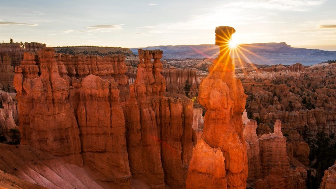
The combination the park itself recommends for first time visitors links two trails into one loop between Sunrise Point and Sunset Point. The gentlest direction drops from Sunrise Point on the Queen’s Garden Trail, descending a ridgeline past the Queen Victoria hoodoo and through the garden of smaller formations at the amphitheater floor, then connects to the Navajo Loop and climbs back to Sunset Point. The Navajo side offers two climbs: the Wall Street side, a tight series of switchbacks between high rock walls with Douglas firs growing in the slot, and the Two Bridges side, named for two natural bridges and passing below Thor’s Hammer, the park’s most famous single hoodoo. Wall Street is the more dramatic ascent and the one most often closed by winter ice and rockfall, so the loop’s exact shape is a same day decision based on the park’s trail status. Budget 2 to 3 hours, carry water even in cool weather, and remember that the trailheads sit above 8,000 feet, where most visitors feel the altitude in their legs long before they feel it in their lungs. Hikers who want a longer below rim day can extend into the Peekaboo Loop from Bryce Point, the same country covered from a different trailhead in our Needles District of Canyonlands guide for readers comparing Utah’s red rock trail systems.
What is there south of the amphitheater?
The park road continues about 18 miles south from the amphitheater to Rainbow Point and Yovimpa Point, the highest ground in the park, with pullouts at Natural Bridge, Agua Canyon and Ponderosa Canyon along the way. This stretch needs a private vehicle in every season because the shuttle never serves it. It is the right afternoon move: the amphitheater viewpoints face east and reward mornings, while the southern overlooks look out across the Grand Staircase toward Arizona and hold their light later in the day. Give the drive at least two hours with stops, watch for deer on the road near dawn and dusk, and note that oversize vehicles face parking restrictions at the main viewpoints during shuttle hours, with the additional parking lot across from the Visitor Center and the Shuttle Station lot in Bryce Canyon City set aside for them.
When should a first visit be timed?
Late spring and early autumn balance open trails against manageable crowds. The shuttle season, April to mid October, is a fair proxy for the reliable hiking window, and the combination loop is at its best when both of its sides are open, which winter ice often prevents. Summer brings the full ranger program and the longest shuttle hours, plus afternoon thunderstorms that make below rim trails a morning activity. Winter is quiet and the hoodoos under snow are extraordinary, but it is a rim and viewpoint trip: short days, closed trail sections and no shuttle. Whatever the season, the park’s own Bryce Canyon homepage posts the current alerts, and the park has already noted that the 2027 shuttle season will start in April. Book lodging in Bryce Canyon City or at the park lodge early for the May to September window, when viewpoint parking lots can fill by mid morning.
Frequently Asked Questions
Is the Bryce Canyon shuttle mandatory?
No. The National Park Service states plainly that the shuttle is not mandatory anywhere in the park. It is free with park admission, runs about every 15 minutes in season, and is the most predictable way to move between the four main viewpoints, but visitors may drive to every viewpoint themselves.
How much does Bryce Canyon cost to enter in 2026?
A private vehicle pass costs $35 and is valid for 7 days. Motorcycles pay $30 and visitors on foot or by bike pay $20 per person. Since January 2026, non US residents aged 16 and over pay an additional $100 per person unless admitted on an annual pass, and the park does not accept cash.
How long does the Queen’s Garden and Navajo Loop hike take?
The combination is 2.9 miles with about 625 feet of elevation change and typically takes 2 to 3 hours. That allows for photo stops at the amphitheater floor and a steady pace on the switchback climb back to the rim.
Can the combination loop be hiked in winter?
Sometimes, in part. Winter ice and rockfall frequently close the Wall Street side of the Navajo Loop and can close other below rim sections at short notice. Check the park alerts on the morning of the hike and treat any closure as final, because there is no staffed checkpoint at the trailhead to ask.
Does the shuttle go to Rainbow Point?
No. The shuttle loops only through the Bryce Amphitheater between Bryce Canyon City and the four main viewpoints. Rainbow Point, Natural Bridge and the rest of the southern scenic drive require a private vehicle in every season.
Featured image: Thor’s Hammer and the Bryce Amphitheater at sunrise. Photo from the National Park Service official site (nps.gov), National Park Service, US Government work, used with credit.