 Lucas Meyer
A weekend in Manitou Springs works best when the booking order is settled before the sightseeing order, and it is this: reserve the Manitou Incline first, because its free timed reservations are the one fixed point in the weekend; build the eight spring mineral tasting walk into the other day, because it is free, self guided and happy in any weather; and treat the Cliff Dwellings and the Pikes Peak Cog Railway as the pair of bookable anchors that fill whatever time the mountain leaves over. The town itself, a Victorian spa village folded into a canyon at the foot of Pikes Peak, does the rest. Two days is enough to taste all eight springs, climb or ride to serious altitude, and still have evenings left for the arcade, the galleries and the creek side patios of Manitou Avenue.
Quick Facts
- Town: Manitou Springs, Colorado, at the foot of Pikes Peak, a short drive west of Colorado Springs on US Highway 24
- Mineral springs: 8 naturally carbonated springs on a free self guided tasting walk; maps and a souvenir tasting cup, $3 each or 2 for $5, at the Chamber of Commerce and Visitors Bureau, 354 Manitou Avenue, per the official visitor site checked on November 19, 2026
- Manitou Incline: 2,768 steps climbing nearly 2,000 vertical feet in under a mile, grades approaching 68 percent; a free reservation and signed waiver are required for every hiker, per the City of Manitou Springs
- Incline parking: Dillon Mobility Hub, 134 Manitou Avenue, with shuttle Route 33 to the trailhead area; paid parking enforced daily from 5 a.m. to 6 p.m.
- Cog Railway: The Broadmoor Manitou and Pikes Peak Cog Railway climbs about 9 miles from its depot at 515 Ruxton Avenue to the 14,115 foot summit of Pikes Peak; book ahead on the railway’s official site
- The springs are for sipping: Manitou’s mineral springs are cold and naturally fizzy drinking springs, not hot soaking pools
- Altitude: The town sits well above 6,000 feet and the Incline tops out near 8,600 feet, so pace and water matter even for fit visitors
- Prices checked: November 19, 2026, against the Manitou Springs official visitor site and the City of Manitou Springs
How does the eight spring tasting walk actually work?
The springs are the reason the town exists, and the walk that links them is the best first morning a weekend here can have. Eight naturally carbonated springs rise through the limestone aquifers under the town, each forced to the surface by its own natural fizz and each carrying a different mineral load, which is why no two taste alike. The Manitou Springs official visitor site runs the self guided version: collect a map and the mineral chart at the Chamber of Commerce and Visitors Bureau at 354 Manitou Avenue, pick up the collapsible souvenir cup for $3, two for $5, cash only, with the money supporting the Mineral Springs Foundation, and then walk the town fountain to fountain. The route is a gentle education. Shoshone Spring carries the highest mineral levels of the group and was the spring nineteenth century physicians recommended most. Navajo Spring bubbles up behind the candy shop that began life as its bottling works sampling room. Cheyenne Spring, once bottled commercially, now pours through a cast bronze font in the stone spa building raised around it in 1893. Twin Spring is the locals’ favourite, sweet enough that residents mix it into what the town calls Manitou lemonade. Iron Spring Geyser, drilled in 1910 on Ruxton Avenue, was in its day the most popular spring in town. None of this requires a ticket, a guide or a schedule, and the whole loop fits inside two unhurried hours with stops.
What does the Manitou Incline demand, and how is it booked?
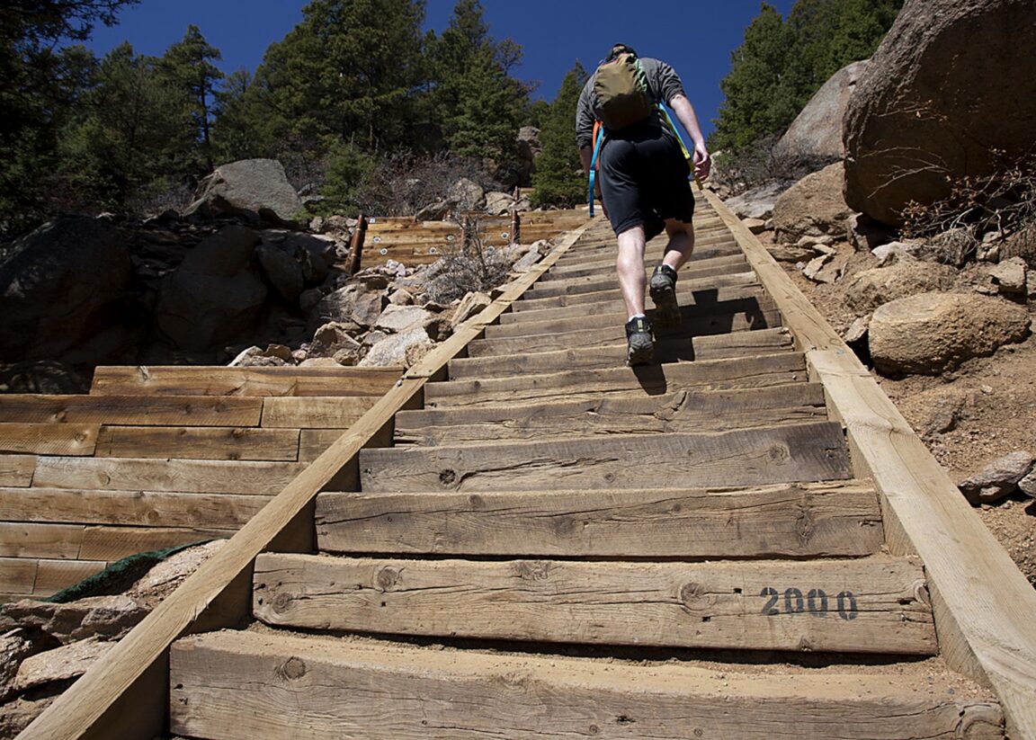
The Incline is the weekend’s serious appointment. It is a former cable car track climbing the mountainside above Ruxton Avenue in a single straight line: 2,768 steps, nearly 2,000 vertical feet of gain in less than a mile, with grades approaching 68 percent, figures the City of Manitou Springs Incline page publishes and every returning hiker respects. The rules are equally plain. Every hiker needs a free reservation and a signed waiver before starting, booked through the city’s reservation system, and the city asks visitors to take the booking seriously because it is how trail capacity is monitored. Parking is the second half of the logistics: the city directs Incline users to the Dillon Mobility Hub at 134 Manitou Avenue, where paid parking is enforced daily from 5 a.m. to 6 p.m., and to shuttle Route 33 for the run to the trailhead. The climb itself is only half the route, because the way down is the Barr Trail, the long distance path to the summit of Pikes Peak whose trailhead also sits at the end of Ruxton Avenue; descending the steps is not the done thing, and the Barr Trail’s gentler grade is kinder to knees anyway. Start early, carry more water than the distance suggests, and treat the town’s altitude as a real factor: the top step stands near 8,600 feet, high enough that visitors arriving from sea level feel it in the first hundred steps. Seasonal hours are shorter from November through April, so a winter weekend should confirm the day’s window on the city page before booking.
How do the Cliff Dwellings and the Cog Railway fill the second day?
The Manitou Cliff Dwellings, just west of town off US Highway 24, are the weekend’s most unusual museum: a set of stone dwellings built in the Ancestral Puebloan style, moved here from a collapsed ruin in the Dolores country of southwestern Colorado and reassembled under a protective cliff overhang in the first years of the twentieth century. Visitors walk through the rooms rather than looking at them from behind glass, and the pairing with the springs walk is instructive, because both attractions are about how people organised life around this canyon’s water and shelter long before the spa era. The Cog Railway is the opposite kind of anchor, pure Victorian engineering still at work. Trains leave the depot at 515 Ruxton Avenue, a few minutes’ walk from the Incline trailhead, and climb about nine miles of rack railway to the 14,115 foot summit of Pikes Peak, the highest cog railway in the world. Summit weather is its own climate, so the railway day and the Incline day are natural substitutes: whichever morning dawns clear belongs to the mountain, and the other belongs to the town. Book the railway ahead on its official site in any busy season, and keep Miramont Castle, the 1895 Victorian mansion museum on Ruxton Avenue, in reserve as the weekend’s wet weather or tired legs option. Readers extending the trip across the state can pair this base with our Colorado National Monument scenic route guide on the Western Slope, or with the grand hotel tradition examined in our Hotel Jerome Aspen guide.
What does the ideal two day order look like?
Day one belongs to the town at walking pace. Start at the visitor bureau for the map and the cup, walk the eight springs through the morning, and let the tasting route double as an orientation to Manitou Avenue’s shops and galleries. Take the afternoon at the Cliff Dwellings, then come back into town for the evening, when the penny arcade, the creek side restaurants and the spring fountains under the street lights give Manitou its resort village atmosphere. Day two belongs to the mountain, in whichever form the booking and the weather allow: the Incline reservation early, down the Barr Trail by late morning, and the afternoon free for the Cog Railway if legs and summit conditions permit, or for a slow second pass at the town if they do not. Base in Manitou itself rather than in Colorado Springs if the weekend allows it. The town’s inns and motels sit inside the walkable core, the springs and the Ruxton Avenue attractions are minutes apart, and staying put removes the parking question from every plan except the Incline’s own.
Frequently Asked Questions
Are the Manitou Springs mineral springs free to taste?
Yes. The eight public springs are free to visit and taste on a self guided walk at any time. The optional souvenir tasting cup costs $3, or two for $5, cash only, at the Chamber of Commerce and Visitors Bureau at 354 Manitou Avenue, and supports the Mineral Springs Foundation. Bringing a reusable bottle works just as well.
Do I need a reservation for the Manitou Incline?
Yes. Every hiker must hold a free reservation and a signed waiver before starting, booked through the City of Manitou Springs reservation system. The Incline climbs 2,768 steps with nearly 2,000 feet of gain in under a mile, and seasonal hours are shorter from November through April, so check the city page for the day’s window when booking.
Are the Manitou springs hot springs for soaking?
No. Manitou’s springs are cold, naturally carbonated drinking springs that rise through limestone aquifers and are tasted from fountains around town. They are a sipping tour, not a soaking pool, and each of the eight has its own mineral taste.
How hard is the Incline for a visitor from sea level?
Harder than the distance suggests. The climb gains nearly 2,000 feet in under a mile at grades approaching 68 percent, and the top step is near 8,600 feet above sea level. Start early, carry water, use the Barr Trail for the descent, and consider a day in town first to adjust to the altitude.
What is the best base for a Manitou Springs weekend?
The town itself. Staying in Manitou Springs puts the springs walk, the Incline trailhead, the Cog Railway depot on Ruxton Avenue and the Cliff Dwellings all within a few minutes of each other, and the only parking that needs planning is the Dillon Mobility Hub for Incline day.
Featured image: A hiker climbs the Manitou Incline past the 2,000 step marker in Manitou Springs, Colorado. Photo from the Manitou Springs official visitor site (manitousprings.org), Manitou Springs Chamber of Commerce and Visitors Bureau, used with credit.