 Maya Chen
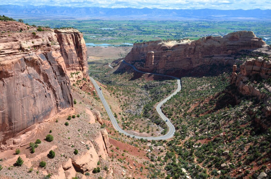
Treat Rim Rock Drive as the destination and Colorado National Monument stops being a detour between Fruita and Grand Junction. The 23 mile historic road climbs switchbacks from either valley entrance, runs the rim of sheer walled red rock canyons past named overlooks and three tunnels, and drops back to the valley at the far end, and the Park Service allows 2 to 4 hours for the drive done properly. Entrance is 25 dollars per private vehicle, the monument is open 24 hours a day year round, and the Saddlehorn Visitor Center and Campground sit 4 miles in from the Fruita entrance. This guide plans the drive as the journey itself: which direction to run it, where to stop, which short trails earn their time, and how to finish the day in Grand Junction or Fruita.
Quick Facts
- Park: Colorado National Monument, between Fruita and Grand Junction, western Colorado
- Rim Rock Drive: 23 miles, historic rim road listed on the National Register of Historic Places, speed limit 25 to 35 mph
- Entrance fee: 25 dollars per private vehicle, 20 dollars per motorcycle, 15 dollars per bicyclist or pedestrian, per the National Park Service
- Hours: Monument open 24 hours a day, year round. Rim Rock Drive may close briefly for snow removal after large winter storms
- Visitor Center: Saddlehorn Visitor Center, 4 miles from the Fruita entrance and 19 miles from the east entrance near Grand Junction
- Camping: Saddlehorn Campground, 22 dollars per night, 11 dollars for Senior and Access Pass holders, reserve on recreation.gov
- Tunnels: Three tunnels on Rim Rock Drive, two on the west side and one on the east side. Pedestrians are not allowed in the tunnels
- Pets: Allowed only in vehicles, in the campground and on paved surfaces
- Last facts check: 16 November 2026, against nps.gov
Why should Rim Rock Drive be the route, not the shortcut?
Colorado National Monument protects one of the grand landscapes of the Colorado Plateau: towering monoliths, vast plateau and canyon panoramas, and sheer walled red rock canyons cut into the edge of the Uncompahgre Plateau above the Grand Valley. Rim Rock Drive is how that landscape was opened up. Championed by John Otto, the monument founder and first caretaker who campaigned for protection until President Taft designated the monument in 1911, the road was built in the 1930s largely with hand tools by local workers, Park Service staff and Civilian Conservation Corps crews, and it is now listed on the National Register of Historic Places in its own right. Driving it slowly, with the overlooks treated as chapters rather than photo stops, is the monument experience. The canyons are the text. The road is how you read them in order.
Which direction should you drive Rim Rock Drive?
Is west to east or east to west better?
Both work, and the choice is really about where your day starts and ends. Entering at Fruita, the west entrance, puts the Saddlehorn Visitor Center and Campground just 4 miles in, which makes it the natural orientation start: maps, the park film, current road and trail conditions, and ranger advice before the rim run begins. Entering at the east entrance near Grand Junction puts the visitor center 19 miles away at the far end, so east entrants should plan the drive as a self guided run and save questions for the end. If you are sleeping in Grand Junction, an east entry with a Fruita finish and a return along the valley floor makes a clean loop. If you are camping at Saddlehorn or sleeping in Fruita, run west to east and end the day rolling down into Grand Junction for dinner. Either way, allow 2 to 4 hours for the drive with stops, exactly as the Park Service suggests. A no stop run takes under an hour and misses the point entirely.
What should you stop for along the rim?
Stop for the overlook sequence rather than every pullout. The essential beats are the canyon rim views near Saddlehorn, the Monument Canyon overlooks with their direct line to Independence Monument, the 450 foot sandstone tower that stands alone in the canyon and hosts a traditional Fourth of July flag raising climb, the Coke Ovens viewpoint for its row of rounded domes, and the Grand View and Cold Shivers Point style rim stops where the valley floor and the Book Cliffs open up beyond the canyon edge. The geology explains itself if you give it time: the hard Wingate Sandstone forms the cliffs and towers, softer layers form the slopes, and the whole plateau edge tilts along a great fold that lifts the rock about 2,000 feet above the valley. Desert bighorn sheep work the slopes below the rim and eagles ride the canyon air, so binoculars earn their space in the car.
Which short trails are worth getting out for?
Two short walks and one historic climb cover most visitors well. The Canyon Rim Trail runs from near the visitor center along the rim toward Book Cliffs View and gives the canyon depth without a descent. The Window Rock Trail is a brief walk to a natural window in the rock with a valley view. For a bigger effort, the Serpents Trail follows the line of the original 1911 era route into the monument, switchbacking up the canyon wall on the alignment drivers used before Rim Rock Drive existed, which makes it the perfect companion piece to the drive itself: walk the old road, then drive the new one. At the east end, the Devils Kitchen Trail drops to a circle of towering rock walls that feels entirely different from the rim. None of these require permits. All of them require water, because there is no food for sale in the monument and shade is scarce.
How do the tunnels and the cycling rules change the plan?
Rim Rock Drive has three tunnels, two on the west side and one on the east, and they set rules that catch people out. Pedestrians are not allowed in the tunnels, which is why campers walking into Saddlehorn Campground must arrange a ride or walk in using Little Park Road outside the southeast end of the park. Cyclists ride the drive in large numbers and must use lights in the tunnels, keep to the rules the Park Service posts for the road, and expect narrow sections with no real shoulder. Oversize vehicles and trailers should check current guidance before committing, since the tunnels and the switchbacks were built to 1930s dimensions. The speed limit of 25 to 35 mph is not a suggestion to beat; it is the pace the road was designed for, and it is what makes the overlooks arrive at readable intervals.
Where should you sleep, Fruita, Grand Junction or Saddlehorn?
Saddlehorn Campground is the only established campground in the monument, set among pinyon and juniper near the visitor center, and at 22 dollars a night it is the best value bed on this route, with Senior and Access Pass holders paying 11 dollars. All sites, including same day sites, must be reserved on recreation.gov, on windows of six months ahead, two weeks ahead and same day, with sites released at 8 a.m. Mountain Time. Loop B is open year round, Loop A runs from 1 April through 15 October, and there are no hookups, showers or dump stations, so arrive self contained. Quiet hours run from 10 p.m. to 6 a.m. and checkout is 11 a.m. Fruita, at the west gate, suits mountain bikers and anyone who wants a small town evening a few minutes from the entrance. Grand Junction, at the east end, is the full service base, with the widest choice of hotels, restaurants and an airport, and it makes the better evening after a west to east drive. For a sense of how fees and passes compare across the system, see our guide to US National Park reservations in 2026, and for another great American rim road treated properly, our Shenandoah Skyline Drive day hikes guide is the eastern companion to this drive.
When should you go and what should you watch for?
Spring and fall are the comfortable seasons on the rim, with mild temperatures for the trails and long light for the drive. Summer brings real desert heat to the canyon floor and the exposed trailheads, so drive the rim in the morning, walk early, and carry far more water than feels reasonable. Winter is quiet and can be beautiful, but Rim Rock Drive may close briefly for snow removal after large storms, so check conditions before you commit to a through drive. The monument is open 24 hours, which makes sunrise and sunset legitimate planning tools rather than ranger station gambles: the Wingate cliffs take colour at both ends of the day, and a rim drive timed for late light, ending in Grand Junction for dinner, is the single best half day this corner of Colorado offers.
Frequently Asked Questions
How much does it cost to enter Colorado National Monument?
Entrance is 25 dollars for a private passenger vehicle, 20 dollars for a motorcycle and 15 dollars for bicyclists and pedestrians, per the National Park Service. America the Beautiful interagency passes are accepted, and a monument annual pass is also available.
How long does Rim Rock Drive take?
The Park Service allows 2 to 4 hours for the 23 mile drive with stops at overlooks. Driving straight through takes under an hour, but the overlooks, the visitor center and at least one short trail are what make the monument worth the entrance fee.
Can you camp inside Colorado National Monument?
Yes, at Saddlehorn Campground near the visitor center, 4 miles from the Fruita entrance. Sites cost 22 dollars per night, or 11 dollars for Senior and Access Pass holders, and all sites must be reserved on recreation.gov, including same day sites. Loop B is open year round.
Are dogs allowed at Colorado National Monument?
Only in limited places. The Park Service allows pets in vehicles, in the campground and on paved surfaces. Pets are not allowed on trails or in the backcountry, so plan rim walks accordingly if you are travelling with a dog.
Is Rim Rock Drive open in winter?
Yes, the drive and the monument are open year round, and the monument is open 24 hours a day. Short closures for snow removal can follow large winter storms, so check current conditions on nps.gov before setting out.
Which entrance should you use, Fruita or Grand Junction?
Use Fruita, the west entrance, if you want the visitor center and campground first, since both sit 4 miles inside that gate. Use the east entrance near Grand Junction if you are based there and plan to finish in Fruita. The drive is excellent in both directions.
Featured image: Rim Rock Drive winding through the red rock canyons of Colorado National Monument above the Grand Valley. Photo: National Park Service, via nps.gov.