 Rafael Santos
Block Island is at its best once summer lets go of it. The island, about 13 miles off the southern coast of Rhode Island and roughly 10 square miles in size, keeps its clay bluffs, its 365 freshwater ponds and its 28 miles of Greenway trails all year, but in September the day-trip crowds thin, the Atlantic is still warm from August, and the island that around 1,000 year-round residents call home starts to feel like theirs again. Come on the year-round ferry from Point Judith, walk the Mohegan Bluffs staircase early, and spend the rest of the day on trails and pond lanes that most July visitors never reach.
Quick Facts
Where: Block Island (the town of New Shoreham), about 13 miles off the southern coast of Rhode Island in the Atlantic Ocean
Size: Roughly 10 square miles, about 7 miles long and 3 miles wide
Getting there: Block Island Ferry from Point Judith (Galilee) in Narragansett, the only year-round route and the only one that carries vehicles; traditional ferry about 55 minutes, high-speed ferry about 30 minutes
Signature sight: Mohegan Bluffs, clay cliffs rising more than 200 feet above the Atlantic on the south shore
The staircase: 141 steps from the Payne Overlook down to the beach below the bluffs
Trails: About 28 miles of Greenway walking trails, plus Rodman’s Hollow and the Clayhead Trail
Ponds: 365 freshwater ponds by island tradition, one for every day of the year
Best shoulder month: September, when the sea is warm, ferries still run often and most summer businesses are open with shorter hours
Facts checked: November 21, 2026, against the Block Island Tourism Council site (blockislandinfo.com), Visit Rhode Island and the Block Island Ferry
Why does September suit Block Island better than July?
September solves the island’s one real problem, which is that everyone wants the same few weeks of it. In midsummer the ferry docks at Old Harbor empty into a village of full restaurants, booked rooms and beaches where the good sand goes early. By September the pattern breaks. School terms pull families home, the bluffs and beaches empty out by mid-morning, and the island’s working rhythm, fishing boats in New Harbor, farm stands, the harborside bars winding down rather than gearing up, becomes visible again.
The trade is honest and worth naming. Some restaurants shorten their weeks, a few seasonal shops close after Labor Day, and the high-speed ferry schedule thins as the month goes on. What does not change is the landscape. The bluffs do not close. The ponds, the moors and the stone-walled lanes are exactly where they were in August, and the ocean, which takes all summer to warm, is usually at its most swimmable in the first half of September. Travelers who prefer an island to a scene will take that deal every time.
How do you get to Block Island, and should you bring a car?
Almost everyone arrives the same way, on the Block Island Ferry from Point Judith, the fishing port at Galilee in Narragansett. It is the only year-round crossing and the only route that carries vehicles. The traditional ferry takes about 55 minutes and lands at Old Harbor, in the middle of the village. The high-speed ferry makes the crossing in about 30 minutes and is passenger-only. Seasonal services also link the island with Newport, New London in Connecticut and Montauk in New York during the warmer months, but Point Judith is the dependable spine of the schedule, and it is the sailing to build a shoulder-season trip around. Check the current timetable and fares at blockislandferry.com before you travel, because frequency drops sharply outside summer.
For a September visit of two or three days, leave the car on the mainland. Vehicle spaces on the traditional ferry are the scarcest commodity in the island’s transport system and must be reserved well ahead, while the island itself is small enough to cover by bicycle, moped, taxi and foot. Old Harbor to the Mohegan Bluffs is about 2.5 miles. A bike makes it in 15 to 20 minutes, with an uphill pull on the approach that the Tourism Council itself warns about. Walking it takes under an hour on Spring Street, and the walk is part of the pleasure in September, past pond after pond with almost no traffic for company.
What makes the Mohegan Bluffs the island’s essential stop?
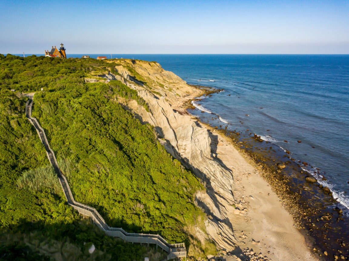
On the south shore, the land simply ends. The Mohegan Bluffs are clay cliffs that rise more than 200 feet above the Atlantic and run for almost three miles along the coast, pale and layered where the sea has cut them, topped with green moorland. From the Edward S. Payne Overlook, reached by a free gravel parking area just past the Southeast Lighthouse on Spring Street, the whole south coast opens up, and on a clear day Montauk, at the end of Long Island, is visible across the water.
The famous staircase drops 141 steps from the overlook to the beach. The Tourism Council describes it plainly as very steep, and it is right: the descent ends with a short scramble over rocks, the route is not suitable for visitors with limited mobility, and the climb back up is the real workout. Wear sturdy shoes, carry water, use the handrails and rest on the way. The beach at the bottom earns the effort. It is rocky, wild and backed by the full height of the cliffs, with no lifeguards and no restrooms, so go prepared and swim with caution in the strong surf. One current caution matters: erosion has changed conditions at the bluffs in recent winters, and parts of the access have been closed at times. Read the posted signs at the overlook and stay inside marked areas.
Pair the bluffs with the Southeast Lighthouse, the red-brick tower standing right beside them above the cliffs. Built in the 1870s and later moved back from the eroding edge, it is the island’s postcard made real, and from the beach below, looking back up, you get the view that explains why: lighthouse on the grass, clay falling away beneath it, and three miles of empty shoreline curving off in both directions.
Where do the 365 ponds fit into a visit?
Island tradition counts 365 freshwater ponds on Block Island, one for every day of the year, and while nobody is auditing the arithmetic, the ponds genuinely shape the island. Great Salt Pond, the big tidal harbor between Old Harbor and New Harbor, is the one everyone sees. The revelation is the small ones: Sachem Pond up by the North Light, Fresh Pond in the island’s middle, and dozens of unnamed kettle ponds sitting in hollows between stone walls and moorland, loud with birds in the shoulder season.
The ponds are also the island’s freshwater lifeline, which is why so much of the land around them is protected. More than 40 percent of Block Island is conserved open space, an extraordinary share for a developed resort island, held through the work of The Nature Conservancy, the Block Island Conservancy and the town. That conservation is the reason the island still looks the way it does, and the Greenway, the trail network that threads the protected parcels together, is how visitors get to see it from the inside rather than from a car window.
How should you walk the Greenway and the island’s wild corners?
The Greenway runs to about 28 miles of marked walking trails, and the Block Island Conservancy sells an inexpensive trail map that is worth buying at the start of a trip rather than improvising from a phone in a field with no signal. Three areas carry a shoulder-season day between them. Rodman’s Hollow, 230 acres of glacial outwash plain south of the island’s center, is a bowl of shadbush, bayberry and native shrubs with panoramic views to the Atlantic, and it connects onward toward the bluffs and the south shore. The Clayhead Trail, on the northeast coast, crosses a parcel of about 190 acres to bluffs of its own and sits on a busy migratory path, which makes September, peak migration, its best month. At the island’s northern tip, the North Lighthouse stands over Sandy Point and the wildlife refuge flats around Sachem Pond, where the walking is flat, the light is huge and the crowds, even in August, rarely bother.
The pattern that works is simple. Do the bluffs early, before any day boats land. Give the middle of the day to a Greenway section, Rodman’s Hollow if you want the interior, Clayhead if you want birds and a second, quieter set of cliffs. End at the North Light for the long evening light, then ride back into Old Harbor as the village settles into the locals’ hour. In September the sun is down earlier and the restaurants that stay open skew toward the people who live there, which is precisely the island this trip is for. Travelers building a wider New England island itinerary can pair this approach with our guide to avoiding the ferry and timing traps at Ocracoke on the Outer Banks, another ferry-only village that rewards the shoulder season, and with Prince Edward Island’s slow red-cliff roads farther north.
What should you know before you go in the shoulder season?
Book the ferry and the room in that order, and keep both flexible. September weather on an island 13 miles offshore can turn a planned beach day into a bluff-top wind day with little notice, and the trip works better if the itinerary bends with it: trails and lighthouses on the grey day, the beach below the bluffs on the clear one. Pack layers and a windproof shell even when the mainland forecast looks kind, because the south shore takes the full Atlantic weather. Finally, respect the closures and the conservation land. The bluffs are actively eroding, the ponds are a drinking-water watershed as well as a postcard, and the island that locals get back each autumn stays worth visiting because visitors treat it as borrowed.
Frequently Asked Questions
How long is the ferry from Point Judith to Block Island?
The traditional ferry takes about 55 minutes and is the only service that carries vehicles. The high-speed ferry takes about 30 minutes and carries passengers only. Point Judith is the only year-round departure point.
How many steps are there at the Mohegan Bluffs?
The staircase from the Payne Overlook to the beach has 141 steps. It is steep, ends with a short climb over rocks, and is not suitable for visitors with limited mobility. Check posted signs on the day, as erosion has led to closures at times.
Does Block Island really have 365 ponds?
That is the island’s own traditional count, one pond for every day of the year. The freshwater ponds, from Great Salt Pond to Sachem Pond and Fresh Pond, are central to the island’s ecology and to its protected open space.
When is the best month to visit Block Island without crowds?
September. The sea is at its warmest, the Greenway trails and bluffs are quiet, migratory birds move through Clayhead and the refuge, and most of the island is still open, though hours shorten and ferry frequency drops as the month goes on.
Can you visit Block Island without a car?
Easily, and for a short shoulder-season stay it is the better choice. The island is about 7 miles long and 3 miles wide. Bicycles, mopeds, taxis and walking cover it well, and the bluffs are about 2.5 miles from the Old Harbor ferry dock.
How much of Block Island is protected?
More than 40 percent of the island is conserved open space, protected through The Nature Conservancy, the Block Island Conservancy and the town of New Shoreham. The Greenway trail network, about 28 miles of paths, links many of the protected parcels.
Featured image: The Mohegan Bluffs and the Southeast Lighthouse on Block Island, Rhode Island. Photo from the Block Island Tourism Council official site (blockislandinfo.com), used with credit.