 Priya Nair
The mainland sea caves of the Apostle Islands begin about 1.5 miles of paddling from the Meyers Beach launch, and the National Park Service wants you to plan that short trip with unusual respect, because Lake Superior here is cold enough to kill in high summer and kayakers have died at these caves. The safe version of the trip is specific: launch at Meyers Beach off Highway 13, paddle the red sandstone cliffs only in calm conditions, wear a wet suit or dry suit and a life jacket, use a proper sea kayak of at least 16 feet, and, unless you are an experienced cold water paddler with practised rescues, go with one of the park’s authorised outfitters on a guided trip. Done that way, on a still morning, the caves are one of the great paddles in the Midwest: arches, chambers and honeycombed cliffs in red and gold stone, seen from water level, in silence.
Quick Facts
- Launch: Meyers Beach, off Highway 13 between Cornucopia and Red Cliff, Wisconsin; $5 parking fee, stairs down to the beach
- Distance: The sea caves start about 1.5 miles from the launch and extend for about 3 miles along the mainland shoreline
- The park: Apostle Islands National Lakeshore, 21 islands plus the mainland unit near Bayfield, Wisconsin
- Water temperature: Averages in the 40s Fahrenheit in May and June and rarely exceeds 60 degrees even in late summer; the park cites an average summer surface temperature of 59 degrees
- Required mindset: Wet suit or dry suit, PFD, spray skirt, marine forecast checked, float plan left with someone ashore
- Not recommended by NPS: Small open boats, canoes, open cockpit or sit on top kayaks and paddle boards at the sea caves
- Emergencies: 911 or marine channel 16; park headquarters (715) 779-3397 for non-emergencies
- Facts checked: 21 November 2026, against the National Park Service Apostle Islands kayaking pages on nps.gov
What are the Meyers Beach sea caves, exactly?
The caves are carved into the red sandstone cliffs of the Bayfield Peninsula mainland, east of Meyers Beach. Lake Superior’s waves have eaten the Devils Island Formation sandstone into arches, pillars, chambers and slots, some large enough to paddle into, others framing the lake like windows. In summer the formations are best seen by boat at three places in the park: the mainland caves near Meyers Beach, and the island caves on Sand Island and Devils Island. The mainland caves are the only ones most visitors can reach on a half day trip without an island crossing, which is why Meyers Beach, with its parking lot, stairs and sandy launch, carries so much of the park’s paddling.
There is also a land option for the same geology. The Lakeshore Trail runs along the cliff tops from Meyers Beach, so on a day when the lake refuses, you can walk above the caves and look down into them instead. Keep that alternative in your plan from the start; the park itself lists sheltered alternatives, including inland lakes, sloughs and Chequamegon Bay, for days when Superior is the wrong place to be.
Why does the Park Service talk about fatalities?
Because the hazard is invisible from the beach. The NPS kayaking page states plainly that kayakers have had fatal accidents at the sea caves, and explains the mechanism: waves from wind and passing boats push against the cliffs and bounce back, creating confused waters around the cave mouths, exactly where paddlers slow down to look and photograph. Add the cold. Hypothermia can begin in as little as 10 minutes of immersion; the park teaches a 1-10-1 rhythm, one minute to get your breathing under control and float, about ten minutes of useful movement before the cold numbs your limbs, and roughly an hour before the cold becomes fatal. A capsize in a cave mouth, in 55 degree water, in a recreational kayak with no spray skirt, is how the accidents happen.
Wind is the other variable. The park notes winds from 5 to 20 knots and waves from 1 to 4 feet as ordinary conditions, and conditions can build during the very hours a cave trip takes. The cliffs offer almost nowhere to land once you are among them, so the decision that matters is made at the launch, with the nearshore marine forecast in hand, not at the first arch.
What are the guide rules, in practice?
The National Lakeshore does not run guided trips itself. Instead, authorised kayak outfitters, listed by the park, offer full and half day guided trips, safety classes and rentals, and authorised water taxis can move paddlers and gear to other launch points. The practical rules that flow from the park’s guidance, and that reputable outfitters enforce, are these. Beginners go guided, full stop; the park itself says guided trips are great for beginners and warns everyone not to exceed their skill level. Groups stay together and never paddle the caves alone. Everyone wears a PFD, a wet suit and a spray skirt, not as rental upsells but as the uniform of the place. Trips launch only in calm conditions and turn back or reroute when the forecast or the water says so, which means a booking is a plan, not a promise: a good outfitter cancelling your cave day in rising wind is the system working.
Independent paddlers are held to the same standard by the environment rather than by a guide. The park recommends a sea kayak of at least 16 feet with bulkheads and a spray skirt, the ability to self rescue quickly in cold water, a paddle float, bilge pump, whistle, marine radio or other reliable communication, a spare paddle, compass and charts, and a written float plan left with a friend or relative that says where you launched, where you are going and when to raise the alarm. Cell phones are not always reliable in the park, and even a successful 911 call leaves help at least 30 minutes away, longer in rough weather.
How should a first timer structure the day?
Book a guided morning trip from Meyers Beach in July or August, the warmest and statistically calmest window, and treat the $5 parking, the stairs to the beach and the outfitter’s gear fitting as part of the experience rather than friction. Mornings matter: Superior often builds wind and waves through the afternoon, so the earliest launches get the glassiest water in the caves and the best light in the arches. Eat in Bayfield afterwards, and keep the Lakeshore Trail cliff walk as the same day backup if the trip is weathered off, so the day still delivers the caves from above.
Island caves are the step up, not the starting point. Sand Island’s Swallow Point caves and the Devils Island caves involve open water crossings where exposure, distance and cold multiply each other, and camping anywhere in the lakeshore requires a permit and a reservation through Recreation.gov. Build toward them over seasons, with skills courses in between, the way the park’s own progression implies.
For more northern water planned the careful way, see our guide to Katmai’s Brooks Falls without the lottery win and our base by base guide to where to stay for Olympic National Park.
Frequently Asked Questions
Can beginners kayak the Apostle Islands sea caves?
Yes, on a guided trip. The park does not run tours but lists authorised outfitters offering guided half and full day trips with the right boats and safety gear. Beginners should not attempt the caves independently.
How far are the sea caves from Meyers Beach?
About 1.5 miles of paddling from the launch, and the cave formations then extend for roughly another 3 miles along the mainland shoreline, according to the National Park Service.
Why is a wet suit needed in summer?
Because Lake Superior barely warms up. Average water temperatures are in the 40s Fahrenheit in May and June and surface temperatures rarely exceed 60 degrees even in late summer, so immersion risks cold shock and hypothermia within minutes.
What kind of kayak does the Park Service recommend?
At least a 16 foot sea kayak with bulkheads and a spray skirt. The park does not recommend small open boats, canoes, open cockpit or sit on top kayaks, or paddle boards for the sea caves or island crossings.
What does it cost to launch at Meyers Beach?
Parking at Meyers Beach costs $5, and there are stairs from the parking area down to the beach. Guided trip prices are set by the authorised outfitters and should be confirmed with them directly.
What should I do if conditions turn rough?
Do not enter the caves, and leave the water for a sheltered alternative. The park suggests inland lakes, sloughs and Chequamegon Bay on rough days, and the Lakeshore Trail above the cliffs gives you the same geology on foot.
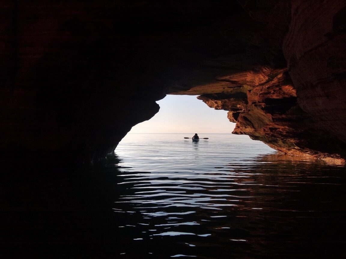
Featured image: A kayaker silhouetted at the mouth of a Meyers Beach sea cave, Apostle Islands National Lakeshore. Photo: I. Campbell, National Park Service (nps.gov), used with credit.