 Kwame Mensah
The east moraine at Wallowa Lake is a hike up the wall that a glacier built. Wallowa Lake, a ribbon of blue water south of Joseph in northeastern Oregon, sits trapped between two long ridges of glacial debris, and the eastern ridge, protected since 2020 as the East Moraine Community Forest, now carries a public trail to its crest: about 3.9 miles round trip with about 795 feet of climbing to a high point around 5,200 feet, from which the lake, the Wallowa Valley and the Wallowa Mountains all line up in one view. It is the essential active morning in the Wallowa Lake area, moderate rather than heroic, and it pairs naturally with an afternoon lake swim and, on a second day, the Wallowa Lake Tramway up Mount Howard for the high country without the climb. This guide explains what the moraine is, how the crest hike runs, what else starts at the lake, and how to pace the three elements, moraine, lake and tramway, across an active trip.
Quick Facts
- Place: Wallowa Lake East Moraine and the East Moraine Community Forest, Joseph, Wallowa County, northeastern Oregon.
- The land: 1,820 acres of moraine protected as a community forest in January 2020, managed for recreation, wildlife habitat, cultural resources, forestry and rangeland, per the Wallowa Lake Moraines Partnership.
- Crest hike: About 3.9 miles round trip, about 795 feet of elevation gain, high point about 5,200 feet, out and back, per the Oregon Hikers Field Guide. A newer 1.5 mile trail description in the Eastern Oregon hiking updates gains about 900 feet, so expect route variants and follow the signed trail on the ground.
- Trailhead: On Highway 351 south of Joseph, following Wallowa Lake signs for about 3.6 miles to the marked trailhead, per the Eastern Oregon trail updates. A second access serves the Turner Lane, east, side.
- Rules on the ground: Dogs on leash, cattle may be present, the trail is shared with bikes and horses, and access is dawn to dusk, per the Oregon Hikers Field Guide listing.
- The lake: Wallowa Lake surface elevation is 4,372 feet. Wallowa Lake State Park occupies the southern tip of the lake.
- Tramway: The Wallowa Lake Tramway rides in about 15 minutes from a base at 4,450 feet to the 8,150 foot summit of Mount Howard, a rise of about 3,700 feet, per the tramway and the Forest Service. It is seasonal, so check operating days and current prices on the tramway official site before planning around it.
- Cost of the moraine hike: The moraine trails are public community forest trails with no ticket required. State park day use and tramway tickets are separate and priced by their operators.
What exactly is the east moraine?
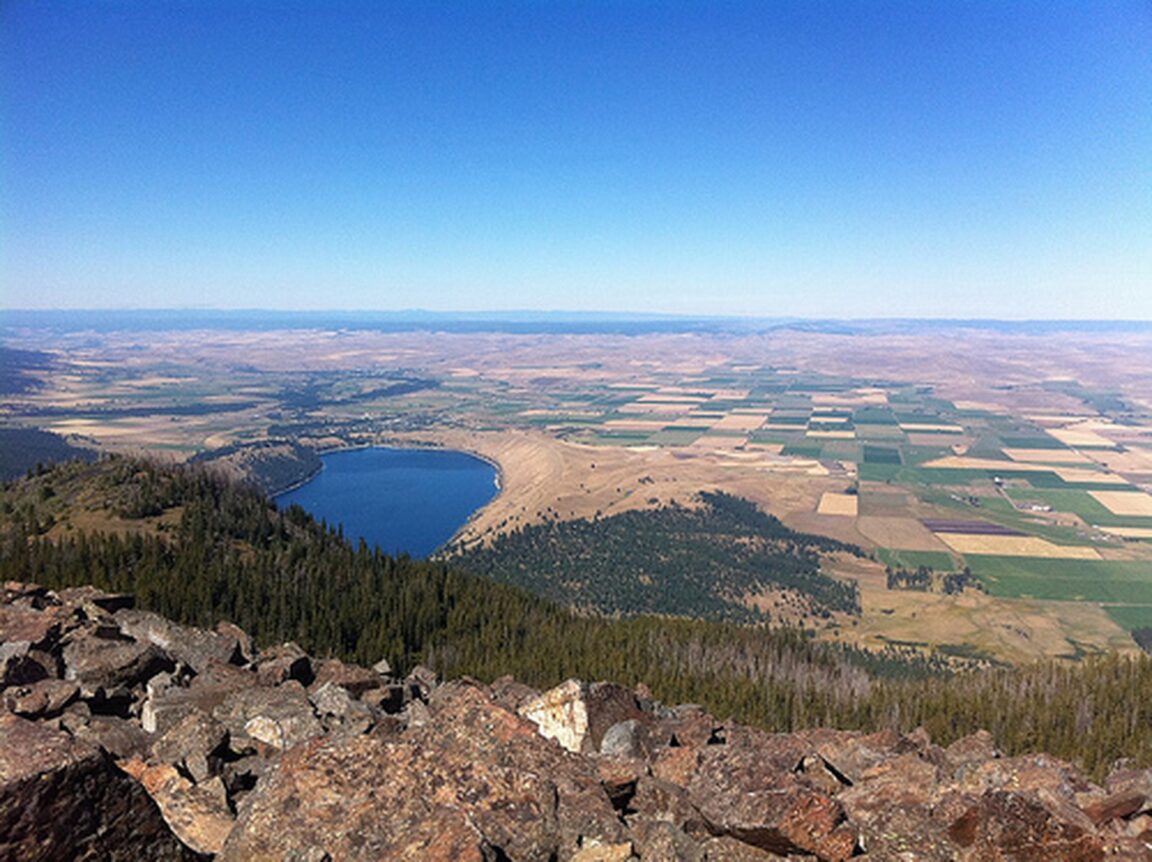
During the Ice Age, glaciers ground down from the Wallowa Mountains and filled this valley, and Wallowa Lake exists because the ice left its load behind. As a glacier stalls and melts, the rock and gravel it carries are dumped along its edges and at its foot, building ridges called moraines. Wallowa Lake is impounded by high moraines at its north end and flanked by them along its shores, and the east moraine is the oldest and largest of them, a ridge rising more than 800 feet above the lake, scattered with granite boulders, called erratics, that the ice carried here and abandoned more than 17,000 years ago.
For generations the ridge was private ranch and timber land that local people crossed by custom rather than by right. That changed in January 2020, when the Wallowa Lake Moraines Partnership, bringing together Wallowa County, the Wallowa Land Trust, tribal and agency partners among others, completed protection of 1,820 acres as the East Moraine Community Forest. The land is managed for five uses at once: recreation, wildlife habitat, cultural resources, forestry and rangeland, which is why a hiker shares the trail system with grazing cattle and working forest, and why the Nez Perce connection to this valley, the homeland of the Wallowa band, is part of the interpretation rather than a footnote. Trail counters logged more than 2,250 visitors in a single late summer and autumn period in 2023, roughly 30 people a day, so expect company without crowds.
How does the east moraine crest hike run?
From the Highway 351 trailhead on the lake side, the route enters through a pedestrian gate beside the green road gate and follows an old road track on a gradual, switchbacking rise through the community forest, passing an information kiosk as the trees thin. Higher up, the track reaches the crest of the moraine and the walk changes character: a footpath runs along the ridge itself, past a solar powered antenna installation, with Wallowa Lake glistening below on one side and the farmland around Joseph and Enterprise opening on the other. Where the crest path splits, the right hand trail climbs one more rise for the grandest vantage, east toward the Seven Devils in Idaho and back across the lake to the high Wallowa peaks.
Calibrate the effort honestly. The field guide figures, 3.9 miles and 795 feet of gain, describe a moderate half day walk, but the crest is open grassland with almost no shade, and the Oregon summer sun at 5,000 feet is stronger than the gentle gradient suggests. Carry water, there is none on the ridge, wear a hat, and start early if the day will be hot. The trail is shared with bikes and horses and dogs must be on leash, with cattle in the area, so give livestock the right of way and close the loop of Leave No Trace habits the community forest asks of visitors. Access is dawn to dusk, and the west, lake side, trailhead draws about two thirds of visitors, with the Turner Lane east side access the quieter alternative.
The viewpoint logic is the reverse of most lake hikes. You are not looking at a mountain across the water. You are standing on the dam the glacier built, looking down the length of the lake it created, with the Wallowa Mountains stacked at the far end. On a clear morning the photograph at the top of this article, Wallowa Lake seen from the Mount Howard side with the moraine ridge running down its eastern shore, is the geography lesson in a single frame.
What else starts at the south end of the lake?
The Wallowa Lake Trailhead, at the end of the highway by the state park, is the gateway into the Eagle Cap Wilderness, the largest wilderness in Oregon, and its trails are a clear step up in seriousness from the moraine. The East Fork Trail is the popular line: it gains almost 1,200 feet in its first two miles on switchbacks to a small pond, continues past Roger Lake and reaches Aneroid Lake, with Tenderfoot Pass beyond at about 8,500 feet for those continuing deeper. The West Fork and Chief Joseph trails offer their own climbs and falls. These are full mountain days with wilderness trailhead registers, real weather exposure and no services, and they belong on a separate day from the moraine, not stacked after it.
Down at lake level, Wallowa Lake State Park at the southern tip provides the recovery infrastructure: the swimming beach and marina area, picnic ground, campground and the small commercial cluster of Wallowa Lake village, with lodging, food and boat rentals in season. The lake water is glacial and cold even in August, which after a moraine morning reads less as a deterrent than as the point. Short, bracing swims, a paddle on the lake in a rented kayak or canoe, and an evening on the shore are the correct counterweight to the dry ridge.
For context on how western public land trips are changing, see the guide to United States national park reservations in 2026, which parks dropped timed entry and which still require it, and for a ranch based version of the same mountain west active trip, the Ranch at Rock Creek in Montana, assessed in full.
How does the tramway change the pacing?
The Wallowa Lake Tramway is the recovery day cheat code, and it is honest about what it is: a Swiss built gondola, constructed in 1970 and described by its operator as the steepest vertical lift for a four passenger gondola in North America, riding a cable of more than 19,000 feet from 4,450 feet at the lake to 8,150 feet on Mount Howard in just under 15 minutes. At the summit a network of short trails leads to viewpoints in every direction, over the lake, the valley, the Eagle Cap Wilderness and, on clear days, into Idaho and Washington, and the Summit Grill serves lunch at the top.
Used well, the tramway converts a rest day into a high alpine day with almost no leg cost: ride up late morning, walk the summit trails gently, eat at the top, ride down, swim. Used badly, it tempts travellers into treating the summit as a substitute for the moraine, which it is not. The two views are different arguments. The moraine is intimate, earned and about the lake formation itself. The summit is the panorama that explains the whole region. Do both, on different days, moraine first.
The tramway is seasonal and weather dependent, and its prices have moved often enough in recent years that this guide deliberately does not print one. Check the operating calendar and current fares on the official Wallowa Lake Tramway site before you build a day around it, and note the last ride up and last ride down times on the day, because missing the final descent turns a recovery day into a very long walk.
How should an active traveller pace a Wallowa Lake trip?
Day one, arrive and orient: the state park, a lake level walk, a short swim, and an early night in Joseph or at the lake. Day two, the moraine: dawn or early morning start from the Highway 351 trailhead, crest by mid morning, down before the heat, lunch, then the lake for the afternoon, swimming and paddling while the ridge you climbed watches from across the water. Day three, choose your level: the tramway and summit trails for the gentle version, or the East Fork Trail toward Aneroid Lake for the serious hiking day, but not both, and keep the evening free for Joseph galleries and dinner. That rhythm, one earned ridge, one cold lake, one big view, is a complete Wallowa trip, and it leaves the Eagle Cap backcountry as the reason to return with a backpack.
Frequently Asked Questions
How hard is the Wallowa Lake east moraine hike?
Moderate. The Oregon Hikers Field Guide lists the crest route at about 3.9 miles round trip with about 795 feet of elevation gain and a high point of about 5,200 feet, on an old road track and a crest footpath. The challenges are sun exposure on the shadeless crest, not technique. Carry water and start early on hot days.
Is there a fee for the east moraine trails?
No ticket is required for the East Moraine Community Forest trails, which are public community forest land protected in 2020. Separate charges apply elsewhere in the area, including state park facilities and the Wallowa Lake Tramway, whose current prices should be checked on its official site.
Can dogs hike the east moraine?
Yes, on leash, per the field guide listing for the hike. Cattle graze in the community forest, the trail is shared with bikes and horses, and access is dawn to dusk. Keep dogs close around livestock and carry water for them, as there is none on the ridge.
What is the Wallowa Lake Tramway and when does it run?
It is a four passenger gondola running from the Wallowa Lake village area at 4,450 feet to the 8,150 foot summit of Mount Howard, a rise of about 3,700 feet in roughly 15 minutes, with summit trails and a restaurant at the top. It operates seasonally and can close for weather, so confirm operating days, hours and fares on the official tramway site before visiting.
Can you swim in Wallowa Lake?
Yes. Wallowa Lake State Park at the south end of the lake has the main swimming and beach area, along with a marina and picnic grounds. The water is glacial in origin and stays cold even in midsummer, so treat swims as short and bracing, and supervise children closely.
Why is the east moraine culturally significant?
The Wallowa Valley is the homeland of the Wallowa band of the Nez Perce, and the moraine and lake sit within that homeland landscape, near the Old Chief Joseph gravesite at the north end of the lake. Cultural resources are one of the five stated management purposes of the East Moraine Community Forest, and visitors should stay on trail, leave artefacts and features untouched, and read the trailhead interpretation.