 Jordan Ellis
Drive it as a loop with three layers: cross the New River Gorge Bridge on US Route 19 in about a minute, walk the steel catwalk 25 feet beneath its deck on the guided Bridge Walk, then descend the old Fayette Station Road in a series of switchbacks until you are standing at river level looking straight up at the arch. That sequence, rim to catwalk to river, is the complete New River Gorge drive, and this guide gives the order, the timing and the costs for each layer.
Quick Facts
- Bridge length: 3,030 feet, with a 1,700-foot arch, the longest steel span in the western hemisphere, per the National Park Service
- Height: The deck is 876 feet above the New River; the Bridge Walk catwalk sits 851 feet above the river
- Bridge Walk price: From $79 per person; the Bridge Day walk is $125, per Bridge Walk
- Bridge Walk format: Guided, 2 hours or more, about 1.25 miles of walking in total, groups capped at 13
- Old road: Fayette Station Road (State Route 82) winds down both sides of the gorge and passes under the bridge to the Tunney Hunsaker Bridge at river level
- Park entry: New River Gorge National Park and Preserve has no entrance fee
- Base town: Fayetteville, immediately south of the bridge on US 19
Start at the rim: what do you see before you drive anywhere?
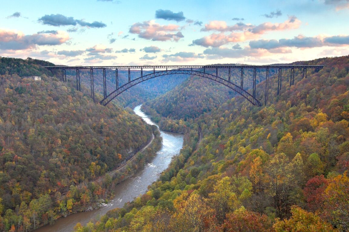
Begin on the north side of the bridge at Canyon Rim Visitor Center, where the Park Service overlooks frame the whole structure before you commit to any part of the drive. The bridge is a single-span steel arch carrying US 19 just north of Fayetteville, West Virginia, in the northern section of the 53-mile-long national park. From the rim you can read its scale properly: 3,030 feet long, 876 feet above the river, with the 1,700-foot arch that the National Park Service bridge page identifies as the longest steel span in the western hemisphere and the third highest bridge in the United States.
One fact shapes everything else: the bridge is a highway, not a pedestrian bridge. There is no walking across the top on an ordinary day. Your on-foot options are the catwalk tour beneath the deck, the rim overlooks, and the trails. Drivers crossing on US 19 get the view for about a minute and should not expect to stop. Plan the crossing as the connective tissue of the route, not as the experience itself. For a contrast in how a park scenic drive can work, see how the Scenic Drive organises a very different landscape in our Capitol Reef first-timer guide.
The catwalk layer: is the Bridge Walk worth booking?
The Bridge Walk is a guided tour along the maintenance catwalk that runs the full 3,030-foot length of the bridge, 25 feet beneath the road deck and 851 feet above the New River. Walkers are harnessed to a continuous safety line and cross in a single file with a guide, on a catwalk about 24 inches wide. The operator, Bridge Walk, prices the standard tour from $79 per person, with the once-a-year Bridge Day walk at $125 and an annual pass listed at $235. Tours run 2 hours or more from check-in to return and cover about 1.25 miles of walking including the approach paths, and groups are capped at 13 guests, according to the Bridge Walk FAQ page.
The practical rules matter before you book. Participants must be at least 8 years old and at least 48 inches tall, and reservations are non-refundable, so treat the booking as final and pick your date carefully. Check in at the Bridge Walk headquarters on Fayette Mine Road in Lansing, near the visitor centre, and allow the full half day around it rather than squeezing it between other stops. Book ahead in autumn, when gorge colour and Bridge Day demand compress availability. If anyone in your party cannot manage moderate activity for two hours, the rim overlooks and the Fayette Station Road drive below deliver the same structure from safer angles, and nobody should feel the catwalk is compulsory.
The old road down: how does Fayette Station Road work?
Before the arch opened in 1977, the only way across the gorge here was the road you are about to drive. Fayette Station Road, signed as State Route 82, winds down the steep terrain on both the north and south sides, passing under the bridge and crossing the river on the low Tunney Hunsaker Bridge at Fayette Station. The Park Service recommends the drive for the views from underneath the bridge, and it is the layer of the route that changes your sense of the structure most: from the river, the arch fills the sky, trains run along the gorge floor, and rafts work the rapids that made this stretch of the New River famous.
Drive it slowly and in the signed one-way pattern, using the pull-offs rather than the travel lane for photographs. The descent is a sequence of tight switchbacks on a narrow historic road, so it suits a standard car driven patiently and is no place for large vehicles or trailers. Allow the better part of an hour for the full descent, the river-level stop and the climb out, more in peak autumn traffic. At the bottom, park in the designated areas near the old bridge, walk out for the head-on view of the arch, and watch the river for a while. This is also the natural picnic layer of the route, with the bridge doing the entertaining.
Fayetteville: where do you eat, sleep and refuel the route?
Fayetteville, the small town immediately south of the bridge, is the base that makes the drive work as a day or a weekend. It holds the lodging, restaurants and outfitters for the northern end of the park, and staying here means you can walk the catwalk in the morning, drive the old road in the afternoon and be back for dinner without a long transfer. The town also anchors the park’s trail network. The Endless Wall Trail, which follows the cliff line near Lansing with repeated gorge viewpoints, and the Long Point Trail, which ends at a rocky promontory facing the bridge, are the two walks that pair best with a driving day, because both repay an hour or two rather than demanding a full expedition.
Whitewater is the other half of a Fayetteville stay. The New River’s rapids below the bridge are run commercially in season, and a raft morning followed by the Fayette Station Road descent gives you the gorge at water level twice, once in it and once beside it. Families building a wider Appalachian park trip can pair this route with the cave tours in our Mammoth Cave family guide, a comfortable second stop on a Kentucky and West Virginia loop.
What is the best order for the full route?
Do the rim first, while the light explains the structure. Walk the catwalk second, on a booked morning slot, when you have already seen the bridge from above and can place what is under your feet. Eat in Fayetteville. Then drive Fayette Station Road in the afternoon, when the sun is moving into the gorge and the arch photographs best from below, and finish with a short cliff-line walk if legs allow. In autumn, reverse the catwalk and the old road if Bridge Day crowds are in town, and in any season keep one unplanned hour in hand. The gorge generates its own weather, and a rim viewpoint in clearing fog is worth the wait.
When should you drive it, and what is Bridge Day?
The route works in every season, but it changes character. Spring brings high water, raft traffic and fresh green walls. Summer is the fullest programme, with every tour and trail operating and the longest days for an unhurried loop. Autumn is the famous season, when the hardwood gorge turns and the catwalk and the old road both earn their keep as colour viewpoints, and it is also the busiest, so book the Bridge Walk and Fayetteville lodging well ahead. Winter strips the leaves and opens the longest sightlines to the arch and the river, at the price of cold wind on the catwalk and the rim.
Once a year, on Bridge Day, the highway itself closes to traffic and opens to pedestrians, and the bridge becomes a festival site with the catwalk running beneath it. It is the only day you can stand on the deck, and the Bridge Walk runs a special $125 tour for it. If your trip can flex to that single autumn Saturday, it is the definitive version of this route. If it cannot, the ordinary sequence in this guide loses very little. The arch, the catwalk and the old road are all there the other 364 days, with far fewer people sharing them.
Frequently asked questions
How much does the Bridge Walk cost?
The standard guided catwalk tour is priced from $79 per person on the operator’s site, the Bridge Day walk is $125, and an annual pass is listed at $235. Reservations are non-refundable, and tours are capped at 13 guests.
Can you walk across the top of the New River Gorge Bridge?
No. The bridge is a working highway carrying US Route 19, and the Park Service states there is no way to walk on top of it. The guided catwalk 25 feet beneath the deck is the pedestrian crossing, except on Bridge Day, when the road itself opens to walkers.
How long does the Bridge Walk take?
Allow 2 hours or more from check-in to return. The full experience covers about 1.25 miles of walking, including the paths at each end, with the catwalk itself running the full 3,030-foot length of the bridge.
Is Fayette Station Road difficult to drive?
It is narrow, steep and switchbacked, and it follows a signed one-way pattern down one side of the gorge and up the other. A standard car driven slowly handles it well. It is not suited to large vehicles or trailers, and you should use pull-offs, not the lane, for stops.
Does New River Gorge charge an entrance fee?
No. Entry to New River Gorge National Park and Preserve is free. Paid elements of this route, such as the Bridge Walk, rafting and lodging, are run by separate operators and booked with them directly.
Prices and tour rules checked 18 November 2026 against Bridge Walk, the official catwalk operator, and bridge dimensions against the National Park Service. Tour availability is seasonal and weather dependent, so confirm your date when you book.