 Camille Baptiste
Trolltunga is a single, very long mountain day, not a photo stop: 27 kilometres return from the P2 car park at Skjeggedal, with about 800 metres of climbing and 8 to 12 hours on the trail, to stand beside a slab of rock that juts out 700 metres above the lake Ringedalsvatnet. Starting higher, from P3 at Magelitopp, cuts the day to 20 kilometres and 7 to 10 hours, and the shuttle bus up the steep road between the two car parks is the single best money saving decision in time and energy terms on the whole route. Timing matters as much as fitness. Experienced hikers may walk on their own only in the summer window, from 1 June to 30 September; outside it, the official advice is to go with a guide, and in winter only with a guide. Read this in November and the honest headline is simple: the self guided season is over, so the choice now is a guided winter hike or a properly booked plan for next summer. Prices and season dates below are the published 2026 figures, checked on 18 November 2026, with 2027 fares not yet published.
Quick Facts
- The hike: Trolltunga, near Odda in Hardanger, western Norway; the rock ledge sits about 700 metres above Ringedalsvatnet
- From P2 Skjeggedal: 27 km return, about 800 metres of ascent, 8 to 12 hours
- From P3 Magelitopp: 20 km return, 7 to 10 hours; P3 is 400 metres higher than P2 and reached by a 4.3 km paved road
- Self guided season: 1 June to 30 September, for experienced hikers only; guided hikes outside that window, and only guided hikes in winter
- Parking in 2026: P1 Tyssedal NOK 330 per day; P2 Skjeggedal NOK 550 per day including the road toll; P3 Magelitopp NOK 600 per day plus a NOK 220 toll, 30 spaces, pre-booking required in season
- Road bus in 2026: P2 to P3, NOK 150 up and NOK 100 down for adults, running 8 June to 27 September
- Odda shuttle in 2026: About NOK 200 one way and NOK 400 return to P2, running 15 May to 27 September
- 2027 fares: Not yet published when checked on 18 November 2026; confirm on trolltunga.com before budgeting
- Emergency: 112 in Norway; emergency shelters on the trail at Store Floren, Endaen and Tyssehol
- Last updated: Facts checked 18 November 2026
Should you start at P2 Skjeggedal or P3 Magelitopp?
P2 at Skjeggedal is the classic start and the one with room to spare: 229 spaces, no pre-booking, open all year, and in 2026 a price of NOK 550 per day with the private road toll included. The price of that simplicity is the first section of the hike itself. From P2 the trail begins with the narrow paved road climbing 4.3 km and 400 metres up to P3, which the official Trolltunga site says takes a bit more than an hour on foot, uphill, on tarmac, before the mountain trail even starts. Walked both ways, that road is close to 9 km of your 27 km day spent on the least rewarding ground on the route.
P3 at Magelitopp removes exactly that problem. The walk drops to 20 km return and 7 to 10 hours, and the day becomes a high plateau hike rather than a road climb with a hike attached. The catch is scarcity: P3 holds just 30 cars, cost NOK 600 per day plus the NOK 220 road toll in 2026, and must be pre-booked in the summer season. Most walkers solve it with the third option, the Trolltunga Road Bus from P2 up to P3, which in 2026 cost NOK 150 up and NOK 100 down for adults and ran from 8 June to 27 September, with morning departures up and afternoon departures down and a gap in the middle of the day. Park at P2, ride up, walk from P3, and keep the road for the bus. However you reach it, P1 at Tyssedal, at NOK 330 per day in 2026, is the fallback for large vehicles and for anyone content with the longest version of all: 38 km return from the lowest car park.
How do the shuttles from Odda work?
Without a car, two bus layers replace the car parks. The Odda shuttle, run by Odda Buss and Odda Taxi, links Odda and Tyssedal with P2 at Skjeggedal; in 2026 it ran from 15 May to 27 September at about NOK 200 one way and NOK 400 return, with the first departures early enough for a full mountain day. The Road Bus then covers the P2 to P3 climb described above. Budget roughly NOK 650 per adult for the full car free version in 2026 prices, and book the morning buses online in high season rather than trusting spare seats at the kerb.
One timing trap deserves its own warning. The road from P1 up to P2 is not a normal open road: in November 2026 the official site listed it as open from 06:00 to 21:00 with traffic control and closed overnight while rockslide protection work continued. Shuttle riders are partly protected from that, because the buses work to the road hours, but anyone driving should treat 21:00 as a hard deadline for the descent, not a guideline, and check the current road status on trolltunga.com on the morning of the hike. Pair Trolltunga with the fjord country further north and our Lofoten Islands guide shows how the same long daylight planning applies above the Arctic Circle.
What is the trail actually like, section by section?
From P3, the mountain trail proper runs about 10 km each way across the plateau, marked with the red T signs of the Norwegian trekking tradition. The first stretch is deceptively gentle, an elevated valley on a good path, before the route climbs steeply up a long rocky slope to the Gryteskaret pass, which the official guide calls one of the most strenuous stretches of the hike. Beyond it, a second climb reaches Trombeskar and a grassy valley popular with campers, then the trail eases down towards Store Floren, where the view of Ringedalsvatnet opens far below and the first emergency shelter stands, stocked for genuine emergencies with sleeping bags, blankets and food rations.
The plateau that follows sits at around 900 metres and stays rough despite the gentler gradients: ups and downs, river crossings on bridges at Endaen, snow patches that can survive well into June, and a second shelter at Endaen and a third at Tyssehol. Only near the end does the trail narrow along the cliff edge, and then Trolltunga itself appears, with four iron steps down onto the rock. In the peak weeks, roughly 20 June to 20 August, the ledge is busiest between 12:00 and 15:00, and the official site puts the photo queue at about 30 to 45 minutes on weekdays and around 60 minutes on Saturdays. Stay back from the edge, always: there is no barrier, and a fall would be fatal. The return is the same 10 km in reverse, on tired legs, which is why the next section matters more than the summit photo.
When should you turn back?
Set the turnaround time before you leave the car park, and make it a clock time, not a feeling. Work backwards from darkness, from the last Road Bus down from P3, from the 21:00 road closure if you drove, and from a realistic return pace, which for most parties is only slightly faster than the walk out. If that time arrives before the ledge is in sight, the hike is over, and the plateau views you have already earned are the day. The official guidance is blunt about why: many rescues on this route involve tired hikers caught by darkness or weather on the way down.
Turn back earlier still in these conditions: if Gryteskaret leaves you doubting your legs with 8 km still to go; if wind, heavy rain or fog arrives on the plateau, where wet rock is slippery and the cliff sections are unforgiving; if snow or ice covers the trail outside the summer window and you have no guide; or if anyone in the group is slowing steadily rather than recovering at breaks. There is no water source guarantee and no toilet on the mountain, so carry all food and water, a head torch even in midsummer, warm and waterproof layers, and a charged phone, and take every scrap of rubbish back down. In a real emergency the number is 112, and the shelters at Store Floren, Endaen and Tyssehol are the fallback, not a plan.
What does the guided winter alternative involve?
From October to May the mountain changes character completely: snow and ice on the route, avalanche risk on the approaches, short days and weather that can turn in minutes. The official position is that experienced hikers walk on their own from 1 June to 30 September, a guided hike is recommended outside that window, and in winter you should go only with a guide. Local companies including Trolltunga Active and Trolltunga Adventures run guided day hikes and snowshoe trips from Odda and Skjeggedal through the off season, and summer guided day hikes started at around NOK 1,500 per person in 2026, with winter pricing set by the operator and the conditions.
A guided winter day is not a lesser version of the summer hike. It is quieter, often nearly solitary, and the ledge above a frozen valley in low Arctic light is a serious mountain experience. It is also genuinely demanding, with guide supplied safety equipment, an early start in the dark, and a leader who owns the turn back decision. Anyone whose Norway trip falls between November and May should book that, or pivot to the gentler wins in our first time in Oslo itinerary, rather than treating the summer route description as an invitation to try it alone on snow.
Frequently asked questions
How long does the Trolltunga hike take?
Allow 8 to 12 hours return from P2 Skjeggedal for the 27 km route, or 7 to 10 hours return from P3 Magelitopp for the 20 km route, plus time in the photo queue at the ledge in peak season. Slower parties and winter conditions take longer, which is why a fixed turnaround time matters.
Can you hike Trolltunga in winter?
Only with a guide. The self guided season for experienced hikers runs from 1 June to 30 September. From October to May there is snow and ice on the route, and the official Trolltunga site recommends guided hikes outside the summer window and says winter hikes should be done only with a guide. Trolltunga Active and Trolltunga Adventures run the guided departures.
How much does parking at Trolltunga cost?
In 2026, P1 Tyssedal cost NOK 330 per day, P2 Skjeggedal cost NOK 550 per day including the road toll, and P3 Magelitopp cost NOK 600 per day plus a NOK 220 toll, with only 30 spaces and pre-booking required in season. The hike itself is free. Fares for 2027 had not been published when checked on 18 November 2026.
Is the P2 to P3 shuttle worth it?
For most walkers, yes. The road from P2 climbs 4.3 km and 400 metres on tarmac and takes over an hour on foot each way. The Road Bus, NOK 150 up and NOK 100 down for adults in 2026, turns that into the 20 km P3 version of the hike and saves your legs for the plateau and the return.
How fit do you need to be for Trolltunga?
Fit enough to walk 20 to 27 km over rough mountain ground with about 800 metres of climbing from P2, and to still descend safely at the end of it. If you do not regularly walk 20 km in hills, choose a guided hike, which adds pacing and local judgement, or a shorter Hardanger walk instead. This is a demanding route, graded for experienced hikers in the self guided season.
Do you need a permit to hike Trolltunga?
No permit or trail ticket is required. What you pay for is parking, the private road toll and any shuttle buses you use. What is required is honesty about season and ability: outside 1 June to 30 September, go with a guide.
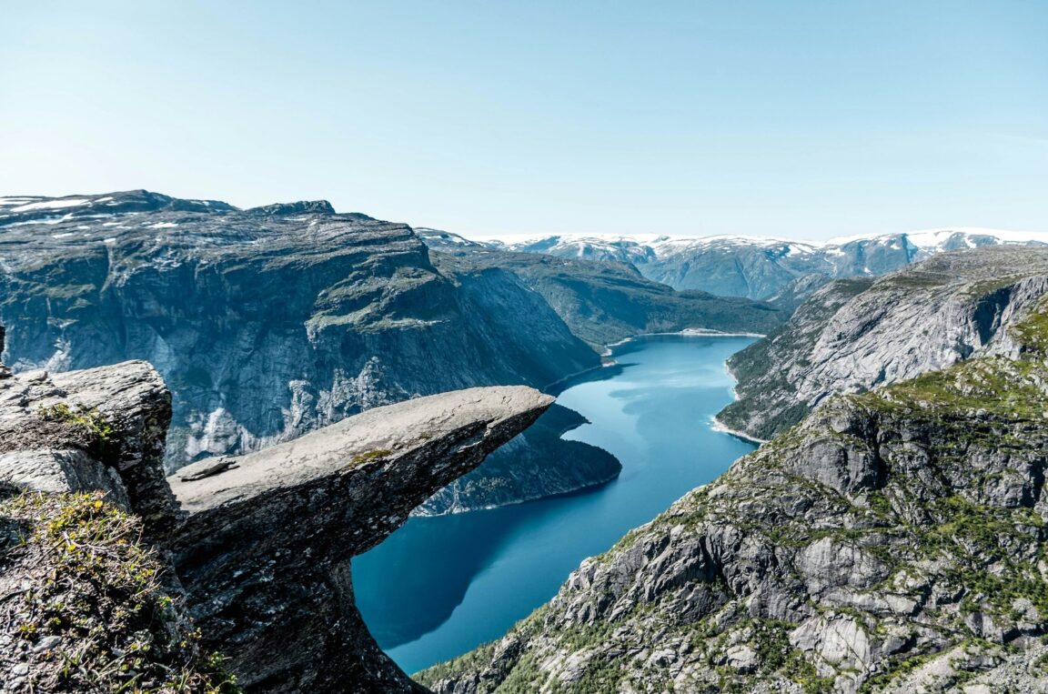
Featured image: The Trolltunga rock ledge jutting out above the turquoise water of Ringedalsvatnet, Norway. Photo via Unsplash (photo 1505312917212-9db5bde78aff), Unsplash License.