 Jonas Lindqvist
Wupatki works best as a single, unhurried loop, not as a string of separate stops. Drive the paved loop road that links Wupatki with Sunset Crater Volcano, start at the Wupatki Visitor Center and its pueblo trail while the light and your attention are fresh, then work north through Wukoki, Lomaki and Box Canyon, and finish at the Citadel and Nalakihu pair near the north entrance. That order puts the monument’s largest pueblo, its ballcourt and its blowhole first, saves the wide Painted Desert views for last, and means one entry pass covers the whole day, because the same seven day pass is valid at both Wupatki and Sunset Crater Volcano.
Quick Facts
- Location: Wupatki National Monument, north of Flagstaff, Arizona, reached from US Highway 89 by a paved loop road shared with Sunset Crater Volcano National Monument
- Entry pass: $25 per private vehicle, $20 per motorcycle, or $15 per person on foot or by bicycle, valid for seven days at both Wupatki and Sunset Crater Volcano, per the National Park Service
- Annual option: Flagstaff Area National Monuments annual pass, $45, also covering Walnut Canyon
- Visitor center hours: 9:00 a.m. to 4:30 p.m.; in winter the center closes on Tuesdays from November 3 to March 2, and on Thanksgiving, December 25 and January 1
- Trail hours: Pueblo trails are open daily from sunrise to sunset; the park road is open around the clock, subject to weather closures
- Headline sight: Wupatki Pueblo, more than 100 rooms, with a community room, a ballcourt and a natural blowhole on a half mile round trip trail
- Time needed: Half a day for the pueblos alone; a full day if you pair the loop with Sunset Crater Volcano
- Facts checked: November 18, 2026, against the National Park Service pages for Wupatki
What is the right order to see Wupatki in?
The loop road settles the question for you if you let it. Enter from the south, from Flagstaff, and the road climbs past the lava flows of Sunset Crater Volcano before descending into open grassland and the red Moenkopi sandstone country of Wupatki. Enter from the north and you reach the Citadel first. Either direction works, but the south to north run has one advantage: the Wupatki Visitor Center sits in the southern half of the monument, and it is the only place to pick up the trail guide, check current conditions, and talk to a ranger before you walk anywhere.
A practical sequence looks like this. First, the visitor center and Wupatki Pueblo. Second, the short spur to Wukoki Pueblo, the tall, isolated ruin on its sandstone outcrop. Third, Lomaki and Box Canyon, the smaller pueblos near the northern end of the loop. Fourth, the Citadel and Nalakihu, which share one parking area and one short trail system. After that the road rejoins US Highway 89, and the Painted Desert opens up to the east as you leave. Readers planning a wider Arizona park run can compare the approach with our Capitol Reef first timer guide, where the same principle applies: one headline sight first, supporting stops after.
Why should Wupatki Pueblo come first?
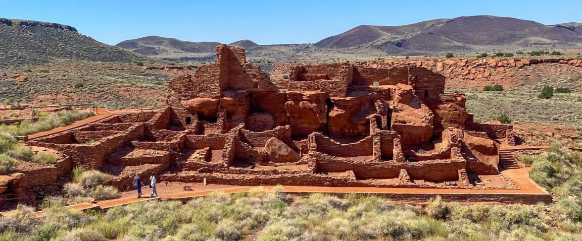
Because it is the monument in miniature. The National Park Service describes Wupatki Pueblo as the largest free standing pueblo in northern Arizona, built around a natural rock outcrop, with more than 100 rooms. The half mile round trip trail behind the visitor center loops around the structure and takes in the features that explain everything else you will see during the day: a large community room, a circular ballcourt that points to trade and ceremony links with cultures far to the south, and rooms built from thin, flat blocks of local red Moenkopi sandstone.
At the far end of the trail sits the blowhole, a crack in the earth connected to a vast underground fracture system. Air moves through it in response to surface air pressure, blowing outward or drawing inward, and on a warm day the cool outflow is startling at ankle height. The Park Service notes that many large pueblo sites in northern Arizona stand near blowholes, which is one of several hints that this landscape was chosen carefully, not settled by accident. Allow 45 minutes to an hour here. Rushing this trail and then lingering at the smaller sites inverts the day.
What do the Citadel and Nalakihu add?
Height and perspective. The Citadel Pueblo crowns a small cinder hill near the north entrance, and the short climb to it earns the widest view in the monument: grassland in every direction, the San Francisco Peaks behind you, and the painted bands of the desert falling away to the east. Below the hill sits Nalakihu, a smaller pueblo at ground level. Seen together, the pair makes the settlement pattern legible. Communities here were not one village but a network of pueblos of different sizes, placed on hills, at canyon edges and beside farmland, within sight and walking distance of each other.
The Citadel is also the one stop where the Painted Desert edge in the headline earns its keep. The colour in the badlands to the east changes through the day, and late afternoon light does the most with it. If you entered from the south in the morning, you will naturally arrive here late in the day, which is the second reason the south to north order works. A similar network of small sites rewards the same patience at Chiricahua, covered in our guide to getting to Chiricahua National Monument.
How does Sunset Crater fit the same day?
Easily, and on the same pass. Sunset Crater Volcano, the youngest volcano in the San Francisco Volcanic Field, erupted roughly a thousand years ago, and its lava flows and cinder cone sit at the southern end of the same loop road. The Park Service links the two monuments for a reason beyond convenience: the eruption reshaped this landscape shortly before Wupatki Pueblo reached its peak, blanketing fields with cinder that held moisture and, for a time, made dry farming more productive. Walking a lava flow trail in the morning and the pueblo trail after lunch turns that connection from a panel of text into something you can see.
Keep the pairing honest about time. Sunset Crater’s main trails plus the drive add at least two hours. If you only have half a day, spend it at Wupatki and do not apologise for it. If you have the full day, do Sunset Crater first while you are fresh for its exposed trails, then slow down at the pueblos.
When is the best time of day and year to visit?
Trails open at sunrise, and the first two hours are the best of the day for most of the year: low light on red stone, empty trails, and temperatures that have not yet built. There is almost no shade anywhere in the monument, and summer afternoons on dark cinder and sandstone are genuinely punishing, so carry water for every person, not per car. Winter brings the opposite bargain: cold wind, short days, a visitor center that closes on Tuesdays between November 3 and March 2, but also solitude and, after storms, snow sitting on red rock.
Spring and autumn are the comfortable middle. Whichever season you choose, check the Park Service alerts page the day before, because the road and trails can close for weather, and the visitor center hours listed above are the winter pattern, not a promise for every date.
What should first timers not do?
Do not leave the trails. The pueblos are fragile, the archaeological sites scattered across the monument number in the thousands, and off trail walking damages both the structures and the biological soil crust that holds this desert together. Do not climb on walls, however solid they look. Do not assume the visitor center will be open when you arrive in winter, and do not arrive without fuel and water: there are no services on the loop road, and the nearest are back in Flagstaff or at Cameron. Finally, do not treat Wupatki as a photo stop on the way to the Grand Canyon. It is a half day place, and it behaves like one.
Frequently Asked Questions
How much does it cost to enter Wupatki National Monument?
The National Park Service lists $25 per private vehicle, $20 per motorcycle and $15 per person arriving on foot or by bicycle, for a pass valid seven days at both Wupatki and Sunset Crater Volcano. The $45 Flagstaff Area National Monuments annual pass and interagency passes are also accepted.
How long is the Wupatki Pueblo trail?
Half a mile round trip, on a paved or groomed surface behind the visitor center, with an accessible overlook a few hundred feet from the building. Allow 45 minutes to an hour to include the ballcourt and the blowhole at the far end.
Can you see Wupatki and Sunset Crater in one day?
Yes. They share one loop road and one entry pass. Allow a full day, do the Sunset Crater lava trails first, and keep Wupatki Pueblo, Wukoki, Lomaki and the Citadel for the rest of the day.
What is the blowhole at Wupatki?
A natural opening connected to an underground system of fractures in the limestone. Air blows out of it or is drawn into it depending on atmospheric pressure, so the earth appears to breathe. It sits at the far end of the Wupatki Pueblo trail.
Is the Wupatki Visitor Center open every day?
No. It is open 9:00 a.m. to 4:30 p.m. but closes on Tuesdays from November 3 to March 2, and on Thanksgiving, December 25 and January 1. The pueblo trails remain open from sunrise to sunset.
Where do you stay for Wupatki?
Flagstaff, about 45 minutes south, is the practical base, with the widest choice of hotels and food. There is no lodging and no campground inside the monument itself.
Image: Wupatki Pueblo, Wupatki National Monument. Photo: National Park Service (NPS Photo), via nps.gov, the monument’s official site.