 Jonas Lindqvist
Death Valley by car works on one rule: the car is the life support system, and fuel, water and distance are planned before scenery. There is no public transportation and no shuttle inside this park, cell phones do not work in most of it, and the sights are strung along two paved roads at distances that surprise every first time driver. The workable sequence is this. Start at the Furnace Creek Visitor Center for current road conditions and a paper map, do the southern Badwater loop in the cool of the morning, return to Furnace Creek to refuel and refill water, then drive Highway 190 northwest to Stovepipe Wells and finish at the Mesquite Flat Sand Dunes in low evening light. Fuel exists at exactly three places, Furnace Creek, Stovepipe Wells and Panamint Springs, and Stovepipe Wells sells gasoline only, with no diesel. Everything below is that sequence, explained step by step, with the distances that catch drivers out named in miles.
Quick Facts
- Park: Death Valley National Park, California and Nevada, the largest national park in the contiguous United States, over 3.4 million acres
- Entrance fee: 30 dollars per private vehicle for seven days. The park is cashless, so pay by card at a fee machine or visitor center, or online in advance, per the National Park Service
- Fuel, the complete list: Furnace Creek (gasoline and diesel), Stovepipe Wells (87 octane gasoline only, no diesel) and Panamint Springs (gasoline and diesel)
- Transport: No public transportation and no shuttle system inside the park. A private or rental car is the only practical way to visit
- Cell service: Phones do not work in most of the park, and the Park Service warns against relying on a vehicle GPS alone. Carry a paper map and download offline maps before entering
- Water: The Park Service recommends at least one gallon of water per person per day, carried in the car, not left to chance at trailheads
- Key distances from Furnace Creek: Badwater Basin 17 miles south, Zabriskie Point about 5 miles, Dantes View about 25 miles, Stovepipe Wells about 25 miles northwest, Mesquite Flat Sand Dunes about 24 miles
- Lowest point: Badwater Basin, 282 feet below sea level, the lowest elevation in North America, per the National Park Service
- Facts checked: November 19, 2026, against National Park Service Death Valley pages and park condition summaries
What do you do before the wheels move?
Three things, in this order, ideally the day before. First, fuel the car to full outside the park or at the first park station you pass, and treat every later station as a top up, never as the plan. Park fuel costs more than town fuel, and the correct response to that is to buy it anyway: the price difference on a tank is small money next to a tow on Highway 190. Second, load the car with water at the one gallon per person per day standard the Park Service recommends, plus food, because between Furnace Creek and Stovepipe Wells there is no shop, no cafe and no tap to improvise from. Third, fix the navigation problem while you still have signal. Download offline maps for the whole park, and pick up the free paper map at the Furnace Creek Visitor Center, because the Park Service is explicit that cell phones do not work in most areas and a vehicle GPS alone is not a plan.
At the visitor center, ask the two questions that change days here: which roads are closed today, and what is the forecast high. Death Valley roads close for flash flooding and storm damage in any season, and famous names on older maps may simply be unavailable: Scotty Castle has been closed since flood damage in 2015 with no reopening date, and Titus Canyon Road has been closed for storm repairs with Park Service timelines running into 2027. Neither fact ruins a first trip, because the classic corridor in this guide uses neither, but both ruin a trip planned from an old guidebook in the car on the day.
Where exactly is the fuel, and what does each station sell?
There are three fuel points for the whole park, and diesel drivers need to read this twice. Furnace Creek, the park hub, sells gasoline and diesel at the Oasis at Death Valley service station, alongside the visitor center, lodging, food and the park most reliable services. Stovepipe Wells, about 25 miles northwest on Highway 190, sells 87 octane gasoline only and no diesel, next to its general store and lodging. Panamint Springs, at the western edge of the park on Highway 190, sells gasoline and diesel. That is the entire network. A diesel vehicle touring the northern park from Stovepipe Wells has no diesel until it returns to Furnace Creek or crosses to Panamint Springs, and a driver who passes Furnace Creek at half a tank heading south to Badwater and then onward has quietly spent the safety margin the park expects you to keep.
The working rule is simple enough to say in one line: never pass a fuel station in Death Valley with less than three quarters of a tank, and never let the trip computer talk you out of it. Distances here are deceptive because the map is empty. Furnace Creek to Stovepipe Wells is about 25 miles, but Furnace Creek to the Racetrack turnoff country and back, or a Badwater loop extended to Ashford Mill, grows past 100 miles without passing a pump. Electric vehicle drivers should plan even more conservatively: charging inside the park is limited and has not stayed consistently operational, so an EV day here is built around a full charge at the gateway town, not around park infrastructure.
What is the right order for Badwater, Artists Drive and the dunes?
Southern loop first, while the day is cool. From Furnace Creek, Zabriskie Point is about 5 miles east on Highway 190 and takes ten minutes, which makes it the natural sunrise stop: eroded badlands in first light, a short paved walk, and back in the car before the valley floor heats. Then drive south on Badwater Road. Badwater Basin is 17 miles from the Furnace Creek junction, a 30 minute drive per the Park Service, and the visit itself is short and level: a ramp and boardwalk to the salt flat edge, then a walk out onto the salt polygons, with the sea level sign visible on the cliff above at 282 feet below it. Do Badwater in the morning not because crowds demand it, but because there is no shade anywhere on that salt and the reflected heat builds fast even in the cooler months.
Return north on the same road and take the Artists Drive loop on the way back, the one way scenic drive through the coloured hills of Artists Palette, which sits conveniently on the return leg rather than needing its own expedition. That completes the south by early afternoon with the car back at Furnace Creek, which is the point: refuel, refill water bottles, eat indoors, and reset. Drivers with a second southern hour in them can add Dantes View, about 25 miles from Furnace Creek, the 5,475 foot viewpoint directly above Badwater, but it is an out and back detour, so it belongs on a two day plan or a winter day with hours to spare, not squeezed into a one day loop. Our companion piece on Death Valley Mesquite Flat dunes in winter covers the dune field in its own season depth, and our explainer on US national park reservations in 2026 sets out which parks, unlike this one, ask for timed entry.
How does the afternoon run to Stovepipe Wells and the dunes?
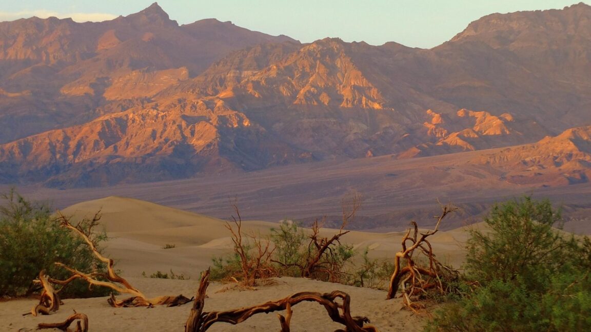
Highway 190 northwest from Furnace Creek climbs over the valley shoulder and drops to Stovepipe Wells, about 25 miles and roughly 35 to 40 minutes of driving. Top up with gasoline here if the tank asks for it, remembering the diesel warning above, and note the general store as the last supply point of the day. The Mesquite Flat Sand Dunes are just east of Stovepipe Wells on Highway 190, about 24 miles from Furnace Creek, with a paved parking area and vault toilets. Late afternoon is their hour. The Park Service notes the dunes are known for dramatic shadows at sunrise and sunset, when ripples and edges stand out in contrast, and the field rewards the timing: the highest dune rises only about 100 feet, there is no official trail, and the standard outing is a self chosen walk of about two miles round trip to the tallest dune across open sand.
Two dune rules matter. Hiking is not advised after 10:00am in the summer heat, a warning that tells you how seriously to take midday sun here in any warm month, and pets are not allowed on the dunes or on any trail in the park, even carried, so a dog stays with a partner at the parking area rotation, never alone in a hot car. Finish the day as the light fails and drive back to Furnace Creek or on to Stovepipe Wells lodging in the dark at park speeds, watching for wildlife on the road, with the fuel and water arithmetic already done. That discipline, not any single sight, is what a good Death Valley day is made of. Drivers continuing west the next day cross to Panamint Springs, the third fuel point, and out toward Lone Pine and Highway 395, and drivers building a wider parks loop can pair this park with our Lassen Volcanic first timer guide for the northern California end of the state.
What catches drivers out, every time?
Four things, all preventable. Underestimating distance, because a park of over 3.4 million acres compresses on a phone screen into what looks like a morning drive. Trusting the phone, in a park where the Park Service says phones do not work in most areas and tells you to carry paper. Skipping a fuel stop because the gauge said half, on roads where the next pump can be 25 to 60 miles away and the wrong fuel type at that. And treating winter as a waiver: November to March is the humane season here, with Furnace Creek days that can be genuinely pleasant, but nights are cold, distances are unchanged, and a breakdown at dusk in January is still a long, dark wait with no signal. The park is not hostile. It is simply indifferent, and it publishes everything you need, at the visitor center, on its condition pages and on the map it hands you for free, to drive it well.
Frequently asked questions
Where can you buy fuel inside Death Valley?
At three places only: Furnace Creek, which sells gasoline and diesel, Stovepipe Wells, which sells 87 octane gasoline only with no diesel, and Panamint Springs, which sells gasoline and diesel. Fill up before entering the park and top up whenever you pass a station.
How far is Badwater Basin from Furnace Creek?
17 miles south on Badwater Road, about a 30 minute drive per the National Park Service. Badwater Basin sits 282 feet below sea level, the lowest point in North America.
Does a cell phone work in Death Valley?
In most of the park, no. The Park Service warns that cell phones do not work in most areas and advises against relying on a vehicle GPS alone. Download offline maps before entering and carry the free paper map from the Furnace Creek Visitor Center.
How much water should you carry?
At least one gallon per person per day, per Park Service guidance, carried in the car from the start of the day. There are no water sources between the park developed areas.
What does entry cost, and can you pay cash?
Entry is 30 dollars per private vehicle for seven days. The park is cashless, so pay by card at a fee machine or visitor center, or buy a pass online in advance.
Can you visit without a car?
Realistically, no. There is no public transportation and no shuttle system inside the park, and the main sights are 17 to 25 miles apart. A rental car, full of fuel and water, is the visit.
Photo credit: Mesquite trees and dunes at Mesquite Flat Sand Dunes in evening light, Death Valley National Park. Photograph by the National Park Service (NPS / C. Augustson), from the park official site, nps.gov. Used with credit.