 Jordan Ellis
Kobuk Valley National Park is planned in the opposite order to most national parks, and getting that order right is the whole trip. Book the charter first, because there are no roads, no trails, no campgrounds and no facilities inside this 1.7 million acre park north of the Arctic Circle, and every visit starts with a bush plane or a boat. Settle the season second, because the Great Kobuk Sand Dunes and the Onion Portage caribou crossing reward different weeks. Only then does it make sense to think about Kotzebue, the gateway town where the park visitor center, the Northwest Arctic Heritage Center, actually sits, about 100 miles west of the dunes. This guide works through that order, step by step, using National Park Service guidance checked on November 19, 2026.
Quick Facts
- Location: Northwestern Alaska, about 25 miles north of the Arctic Circle, between the Baird Mountains to the north and the Waring Mountains to the south
- Access: No roads in or out. Plane or boat in summer, snowmobile in winter. Air taxis work out of Kotzebue and Bettles
- Entrance fee: None. There is no entrance gate and no timed entry system
- Facilities: None inside the park. No trails, no campgrounds, no water, no food, no fuel
- Visitor center: Northwest Arctic Heritage Center in Kotzebue, open daily 8:00am to 12:00pm and 1:00pm to 5:00pm, phone 907-442-3760
- Signature sight: Great Kobuk Sand Dunes, about 25 square miles of active dunes rising to about 100 feet, described by the Park Service as the largest active sand dunes in the Arctic
- Caribou crossing: Onion Portage, called Paatitaaq in Inupiaq, where the Western Arctic Caribou Herd swims the Kobuk River on its spring and fall migrations
- Best window: July, August and early September for open rivers and workable weather, per Park Service guidance
- Prices checked: November 19, 2026. Charter flying is quoted per trip by each operator, so no charter price is stated here
Why does the charter decision come before everything else?
Because the charter is the trip. Scheduled flights run from Anchorage to Kotzebue and from Fairbanks to Bettles, and from either town an authorized air taxi carries visitors the rest of the way, landing on river bars, on lake shores or, with wheeled aircraft, directly on the sand at the edge of the Great Kobuk Sand Dunes. The Park Service lists commercial operators offering air taxi, guided rafting and other services, with offices in Kotzebue and Bettles, and it is blunt about the baseline: the park has no roads, trails or campgrounds, and visitors must be self sufficient, especially in winter. That means the questions that matter are asked of a pilot, not a hotel desk. Where exactly will the plane land for the dunes. Is the landing on sand, on a gravel bar, or on the Kobuk River by floatplane with a cross country walk of roughly two miles to the sand. What is the weather call procedure, who carries the satellite communication, and what happens to the price if the pickup moves a day for wind or low cloud. A first time visitor should also allow far more time than the map suggests. The flight logistics alone can absorb a day at each end once connections and weather are counted, and most well planned visits give the park itself several days, split between the river and the dunes, rather than treating it as a day trip. It is not one, and cannot be made into one.
What are the Great Kobuk Sand Dunes, and how do you actually stand on them?
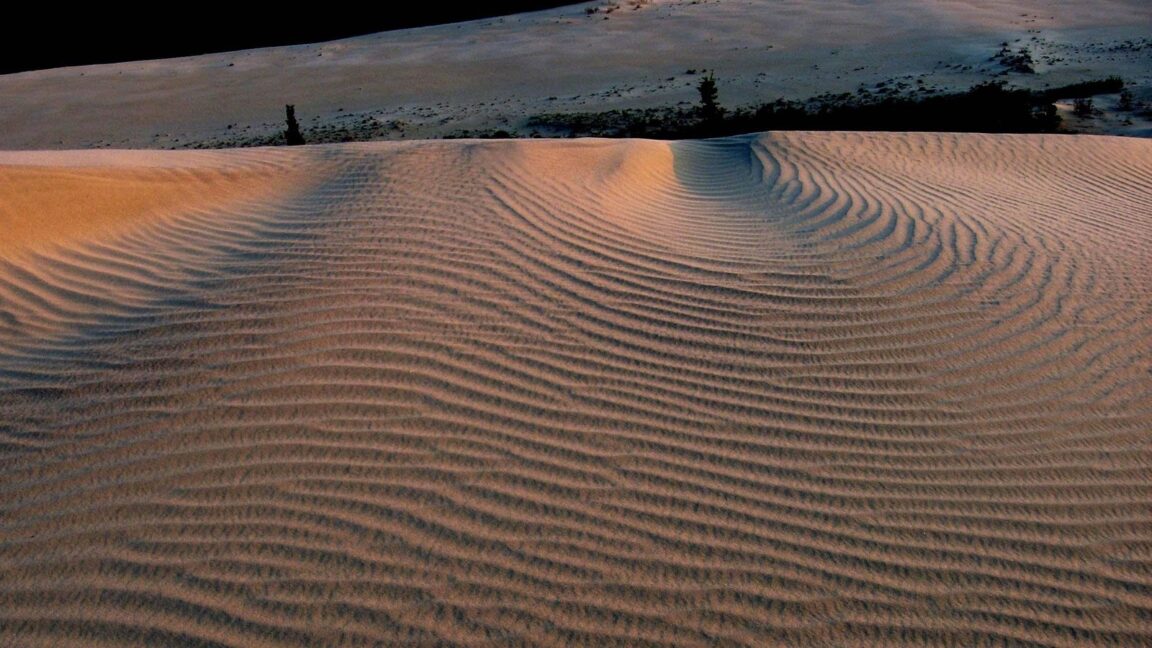
The dunes are a leftover of the last ice age. Glaciers ground mountain rock into sand, meltwater spread it across the valley floor, and wind has kept about 25 square miles of it bare and moving ever since, in the Great Kobuk field south of the Kobuk River, with two smaller fields, the Little Kobuk Sand Dunes and the Hunt River Dunes, bringing the park total to roughly 30 square miles. Individual dunes rise to about 100 feet. The contrast is the experience: rippled, open sand, hot enough that the Park Service warns summer temperatures on the dunes can reach 100 degrees Fahrenheit, edged by spruce forest and tundra, with the Baird Mountains on the horizon. There are no marked routes on the sand. Visitors walk the ridges, follow caribou tracks that cross the field in spring and fall, and pick camps on durable surfaces away from the riverbanks used by wildlife. Two cautions from the Park Service deserve space in any plan. Near creeks and springs the sand can be saturated and lose its footing, so test the ground ahead, ideally with a walking stick. And this is bear country, for both brown and black bears, so food storage and camp discipline follow standard Park Service bear guidance from the moment the plane leaves. For readers comparing Arctic park logistics, our guide to Denali’s Teklanika River corridor for first time visitors shows how different a road corridor park feels next to a park with no road at all.
When do the caribou cross at Onion Portage, and what should you expect?
Onion Portage sits on the north bank of the Kobuk River in the eastern park, and its Inupiaq name, Paatitaaq, refers to the wild onions that grow there. People have taken caribou at this crossing for more than 9,000 years, because the geography funnels the Western Arctic Caribou Herd to the same swimming place on its migrations between calving grounds north of the Brooks Range and winter range to the south. Archaeologists working here from the 1960s onward documented layer upon layer of that occupation, and the site is a National Historic Landmark. The herd still crosses in spring, heading north, and again in fall, and Park Service researchers collar female caribou as they swim the river at Onion Portage. Timing is the honest complication. The fall movement generally builds from late August into September and can stall or surge with weather, and the Park Service’s own caribou monitoring notes that the number of animals migrating south across the Kobuk has declined in recent years for reasons still being studied. The herd itself is far smaller than at its peak of nearly 500,000 animals in 2003, counted at about 259,000 in 2017. So plan a fall trip around the crossing as a possibility to build days around, not a spectacle with a date. Hunting at Onion Portage today is limited to federally qualified subsistence hunters, and visitors should treat the area as what it is, a living Inupiaq harvesting place and an archaeological site where nothing is collected, dug or disturbed. A river based trip that floats or motors the Kobuk in late August or early September gives the best odds of seeing animals on the move while still finding the river open and the dunes walkable.
Why is Kotzebue the real base, and what do you do there?
Kotzebue, a predominantly Inupiaq coastal community on a gravel spit above Kotzebue Sound, is where the park is administered and where almost every trip stages. The Northwest Arctic Heritage Center combines the park visitor center with museum exhibits on the Arctic ecosystem and Inupiaq culture, a film program and ranger advice on weather, wildlife and backcountry logistics. That stop is not a courtesy call. It is where a first time visitor confirms river conditions, hears the current bear and caribou picture, and sanity checks a route with people who watch this valley daily. Build a full Kotzebue day into the itinerary rather than a transfer sprint, sleep in town before flying out, and keep the return night in town as well, so a weather delay eats a hotel night instead of a flight home from Anchorage. The same staging logic applies at the park’s other gateway, Bettles, reached from Fairbanks, which suits itineraries approaching the eastern park and Onion Portage. Readers planning a wider Alaska park circuit will find the same gateway discipline in our day trips from Wrangell-St Elias’ Kennecott mill town, where the base town decision shapes everything downstream.
What does the no facilities reality actually demand of you?
Everything a normal park provides, you provide. Water is carried or treated from creeks and the river. Food, shelter, stove fuel, repair kit, first aid and emergency communication all fly in with you, and all waste flies out. Weather is a planning factor in every month: summer days often reach the 60s Fahrenheit, with hotter spells, but the Park Service warns of snow, near freezing temperatures and long stretches of cloud, wind and rain in summer too. The sun does not set between early June and early July, which scrambles sleep more than most visitors expect, and mosquitoes are at their worst in June and July. There is no cell coverage to plan around and no ranger station inside the park to walk to. Experience matters here, and the Park Service says so plainly, describing Kobuk Valley as a place where visitors should be seasoned in wilderness travel. A guided trip with a listed operator is the sensible default for a first visit, with the guide carrying the river, bear and weather judgment that the park assumes you have. Budget honestly around that choice: with no entrance fee, the money in a Kobuk trip is the money spent getting to Kotzebue, chartering onward and provisioning properly, which is why our breakdown of what a trip to Kenai Fjords’ Exit Glacier actually costs is a useful contrast, a road accessible park where the cost lines look completely different.
Frequently Asked Questions
Is there an entrance fee for Kobuk Valley National Park?
No. The park charges no entrance fee and runs no reservation or timed entry system. The significant costs are travel to Kotzebue or Bettles, charter flying or boating into the park, and provisioning, since there are no services inside the park.
How do you get to the Great Kobuk Sand Dunes?
By chartered air taxi from Kotzebue or Bettles, arranged with a Park Service listed operator. Wheeled aircraft can land on the sand near the dunes, while floatplanes land on the Kobuk River, leaving a cross country walk of roughly two miles to the dune field. There are no roads or trails.
When is the best time to see caribou at Onion Portage?
The herd crosses on both migrations, northbound in spring and southbound in fall. The fall crossing, generally from late August into September, pairs best with open rivers and a workable visitor season, but exact timing shifts with weather and herd movement, and recent fall crossings have been smaller. Treat sightings as likely over several river days, never guaranteed on a single day.
Can you visit Kobuk Valley in winter?
The park is open year round and winter access is by snowmobile or ski equipped aircraft, but the Park Service frames winter as expert territory, with extreme cold, darkness and no support. First time visitors should plan for the July to early September window.
Where is the Kobuk Valley visitor center?
In Kotzebue, at the Northwest Arctic Heritage Center, not inside the park. It is open daily from 8:00am to 12:00pm and 1:00pm to 5:00pm, and rangers there provide the current conditions briefing that should precede any backcountry departure. The phone number is 907-442-3760.
How many days do you need for Kobuk Valley?
Plan on at least five to seven days door to door from Anchorage or Fairbanks, including gateway nights in Kotzebue or Bettles at both ends for weather, and several days in the park split between the Kobuk River and the dunes. Shorter plans leave no margin for the delays this park routinely imposes.
Featured image: Great Kobuk Sand Dunes at golden hour, Kobuk Valley National Park. Photo: National Park Service, via nps.gov, the park’s official site. Prices and hours checked November 19, 2026.