 Camille Baptiste
The Laugavegur is decided at the booking stage, not on the trail. This 55 kilometre route from Landmannalaugar to Thorsmork is walked north to south in four stages, hut places sell out fast for July and August, and the Iceland Touring Association, Ferdafelag Islands, expects you to start with confirmed hut or campsite bookings already in hand. Book the full chain of nights first, in the order Landmannalaugar, Hrafntinnusker, Alftavatn and Emstrur, then plan around the three unbridged river crossings and a season that only runs from late June to early September.
Quick Facts
- Route: Landmannalaugar to Thorsmork (Þórsmörk), in Iceland southern highlands, inside and beyond the Fjallabak Nature Reserve
- Distance: About 55 kilometres. Ferdafelag Islands lists 54 kilometres in its trail panel and 55 kilometres in its route text, so treat every figure as approximate
- Standard plan: Four walking days, with nights at Hrafntinnusker, Alftavatn and Emstrur
- Stages: 12 km in 4 to 5 hours, 12 km in 4 to 5 hours, 16 km in 6 to 7 hours, and 15 km in 6 to 7 hours
- Direction: Huts are booked north to south only, from Landmannalaugar to Thorsmork
- Season: Usually late June to early September, with July and August the most reliable months
- Booking rule: Confirmed hut or designated campsite bookings are expected before you start. Wild camping along the trail is not allowed
- River crossings: At least three rivers must be waded, with no bridge. Others on the route have footbridges
- Sleeping: Ferdafelag Islands mountain huts with shared sleeping space and cooking facilities, or the campsites beside them. Bring a sleeping bag and all of your food
- Safety basics: Leave a travel plan at safetravel.is, check the Icelandic Met Office forecast at vedur.is daily, and call 112 in an emergency
Why does the hut booking sell out first?
The Laugavegur is not a trail you can improvise night by night. The huts are small, the season is short, and the booking system works as a chain. Ferdafelag Islands, known as FI, runs most of the huts on the route and books them in one direction only, north to south, so every hut hiker is trying to assemble the same sequence of nights in the same order. FI warns that huts often sell out quickly in peak season, and accommodation cannot be guaranteed without a reservation.
That has two practical consequences. First, a single missing night breaks the whole plan, because the stages are fixed by where the huts stand, and camping is restricted to the designated campsites beside the huts. Second, the release pattern rewards people who decide early. Recent seasons have seen FI sell Laugavegur nights as route packages of three to five nights as well as by the night, with some stops, including Hrafntinnusker, Emstrur and Thorsmork, sold only as part of a package at times. Package rules and prices change by season and are set on the FI booking site, so check the current terms there rather than relying on a price quoted in any guide, including this one.
If the hut chain for your dates is gone, the honest alternatives are the campsites beside the same huts, a different week in the season window, or a guided trip that holds its own allocations. What does not work is arriving at Landmannalaugar in July hoping a bunk will appear. Wardens manage full houses in peak season, and the first stage climbs into exposed high country where an unplanned night is a safety problem, not an inconvenience.
What are the four stages, day by day?
Day one runs from Landmannalaugar to Hrafntinnusker, 12 kilometres in four to five hours with about 470 metres of ascent, the only climbing day of the four. The route crosses the Laugahraun lava field and climbs through the rhyolite hills towards the highest hut on the trail. Snowfields and snow filled ravines can persist here well into the season, and FI advises care on thin snow bridges early in summer. This is the day that punishes a late start and a heavy pack.
Day two drops from Hrafntinnusker to Alftavatn, 12 kilometres in four to five hours with about 490 metres of descent. The walking is easier on paper and harder on knees. The first significant ford, the Grashagakvisl, comes on this stage, although early in the season it can still be crossed on snow. Alftavatn, a hut and campsite beside a lake, feels like the first genuinely sheltered stop after two days of open highland.
Day three is the long one, from Alftavatn to Emstrur, listed by FI at 16 kilometres in six to seven hours with little net height change. FI own material also lists this leg at 17 kilometres in one itinerary block, so plan food, water and daylight for the longer version. The day crosses black sand plains, passes the alternative hut site at Hvanngil, which is also the useful fallback if Alftavatn is full when you book, and contains the densest sequence of river decisions on the trail, covered in the next section.
Day four runs from Emstrur to Thorsmork, 15 kilometres in six to seven hours with about 300 metres of descent. It starts among the canyons of the Markarfljot river, crosses a bridge over the Sydri-Emstrua, and finishes by wading the Thronga before the path drops into the birch woods of Thorsmork. The change is abrupt and is the payoff of the walk: four days of lava, ash and open sky end in a green, sheltered valley. Most walkers stay at the Langidalur side of Thorsmork, where FI has its hut, although the valley has more than one base, so confirm exactly which Thorsmork stop your booking and your bus use.
Which rivers do you wade, and in what order?
At least three crossings have no bridge, and the order matters because each belongs to a different day and a different kind of tiredness. First comes the Grashagakvisl on day two, between Hrafntinnusker and Alftavatn, sometimes still snow bridged early in the season. Day three then brings the Bratthalskvisl soon after leaving Alftavatn, a bridged crossing at the Kaldaklofskvisl near Hvanngil, and then the Blafjallakvisl, an unbridged glacial river that FI singles out as one to respect. The final wade is the Thronga on day four, shortly before Thorsmork, the other river FI names explicitly. Other streams on the route, including the Fremri-Emstrua and Ljosa as well as the Sydri-Emstrua, are crossed on footbridges.
Glacial rivers follow a daily rhythm that should shape your start times. They tend to run lowest in the morning and rise through the day as meltwater arrives, and they rise quickly after heavy rain. Cross early where you can, unclip your hip belt so you can shed the pack if you fall, keep your boots or sturdy sandals on, use a pole or link arms in a group, and turn back if the water is above the knee and pushing hard. Ask the warden at each hut about the crossings ahead before you leave. Their read on a specific river that morning is worth more than any general guide.
Pack for the fords as a system, not an afterthought: footwear you can wade in without walking the remaining kilometres in soaked socks, a dry bag routine for electronics and the sleeping layer, and trousers you can roll or remove quickly. Wading a cold, fast river on day three with a full pack is a strength and balance task at the end of a six hour walk, which is why the pacing advice below treats day three as the crux rather than day one.
How fit do you need to be, and how should you pace it?
The honest benchmark is back to back days, not a single big walk. A Laugavegur day is four to seven hours of hiking with a multi day pack, on rough ground, in weather that can deliver wind and rain at any point in the season, repeated four days running with river crossings mixed in. If you can walk 15 to 17 kilometres on consecutive days with the pack you intend to carry, and still feel steady on your feet at the end of the second day, the standard four day plan is a reasonable match.
The slower version exists inside the same route. Adding a night, for example at Landmannalaugar before day one or at Thorsmork after day four, does not shorten the stages, but it removes travel pressure from both ends and gives you a weather buffer. FI also publishes three day and two day itineraries, but those combine stages into days of about 24 and 28 kilometres, which is a step up in demand, not an easier option.
Pacing inside each day is mostly about mornings. Start early on day three, so the Blafjallakvisl is crossed as low as possible. Keep day one deliberately steady, because the climb to Hrafntinnusker comes with the heaviest pack of the trip. And build the whole itinerary backwards from the Thorsmork finish, since the bus or extra night you choose there determines how much of day four is walking and how much is waiting.
What are your options when you reach Thorsmork?
There are three sensible finishes. The simplest is a seasonal highland bus out of Thorsmork on the afternoon you arrive, which works if your day four start was early and the crossings behaved. Highland buses serve both ends of the trail in season and are the normal way in and out, since the roads are F-roads for high clearance four wheel drive vehicles, with fords of their own. Book the bus with the same seriousness as the huts, and confirm which Thorsmork stop it uses.
The better finish for most walkers is a night in Thorsmork itself. It converts the end of the trek from a deadline into a place and gives you a buffer if day four runs long. It also needs booking, on the same chain logic as the rest of the trail, so decide it when you book the huts rather than as an afterthought.
The third option is to keep walking. The Fimmvorduhals route continues from Thorsmork over the pass between the glaciers to Skogar on the south coast, adding roughly another 25 kilometres that strong walkers split over two days with a hut night on the pass. It is a serious extension, with its own booking and weather exposure. Treat it as a second trek bolted onto the first, not as a casual extra day. Walkers comparing highland logistics with lowland driving will find our Iceland Ring Road driving guide useful for the before and after, and our Iceland summer packing system covers the layering logic that the highlands demand in a harsher form.
How do you get to Landmannalaugar, and what happens before day one?
Landmannalaugar sits about 180 kilometres from Reykjavik by road, in the Fjallabak Nature Reserve, and is reached only when the highland roads open, on average from around 20 June to 15 September for driving. Most hut walkers arrive on a seasonal highland bus. Drivers need a suitable high clearance four wheel drive vehicle, a check of road conditions at umferdin.is on the day, and, in the 2026 season pattern, a parking reservation for daytime arrivals between 9:00 and 16:00 from 20 June to 13 September, with a service fee of 1,500 Icelandic kronur for a car of up to five seats. Confirm the current year arrangements before relying on those dates.
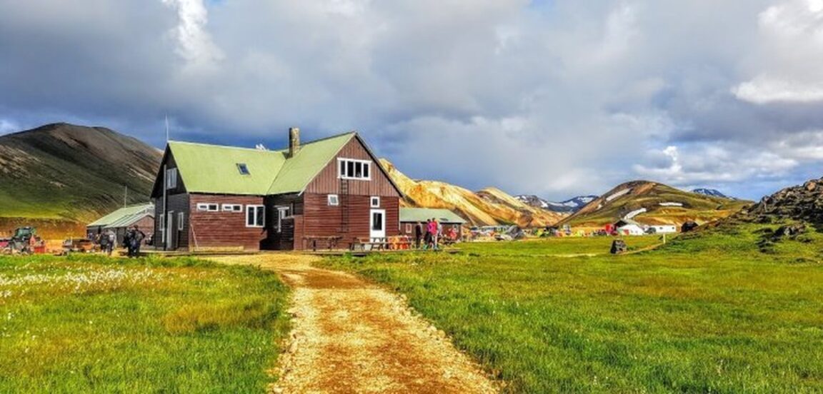
The FI hut at Landmannalaugar sleeps 78 people and anchors a large campsite, and the natural hot pool at the edge of the Laugahraun lava field is the traditional pre trek soak. Arriving the day before day one and starting fresh is the calmest opening available, and it puts you in position to ask wardens about snow on the first stage before you commit. Before any of that, leave a travel plan at safetravel.is, as Icelandic rescue asks every highland hiker to do, and check the forecast at vedur.is. A soak the night before, in the same spirit as the local pools covered in our guide to Iceland hot pots and local pools, is a better eve of trek ritual than a late bus and a rushed start.
Frequently Asked Questions
How long is the Laugavegur Trail?
About 55 kilometres from Landmannalaugar to Thorsmork. Ferdafelag Islands lists 54 kilometres in its trail panel and 55 kilometres in its route text, and its stage figures for the third day appear as both 16 and 17 kilometres, so plan food, water and time using the longer figures.
When do Laugavegur hut bookings open, and how fast do they go?
FI sells the season through its own booking site, in recent seasons offering a mix of single nights and three to five night route packages, with some huts sold only inside packages. FI warns that huts often sell out quickly in peak season, and July and August are the most contested weeks. Check the FI booking site for the current release and package rules for your season, and book the full north to south chain as soon as your dates are fixed.
Can you camp instead of using the huts?
Yes, at the designated campsites beside the huts, and FI expects campers as well as hut users to have confirmed bookings before starting. Wild camping along the trail is not allowed. Camping lowers the cost and the sell out pressure, but you carry a tent and full sleeping system through every river crossing.
How difficult are the river crossings?
FI describes the crossings as generally not difficult, while singling out the Blafjallakvisl and the Thronga for respect. At least three rivers must be waded. Levels rise after heavy rain and through the day with meltwater, so cross in the morning where possible, unclip your hip belt, keep footwear on, and ask each hut warden about conditions before you set out.
What is the best month to walk the Laugavegur?
The season usually runs from late June to early September, and FI identifies July and August as the most popular and reliable period, when huts are open and conditions are generally best. Late June brings more snow on the first stage and higher rivers. Early September is quieter but colder and stormier, and FI booking terms warn that outside 20 June to 15 September running water may not be available at huts and conditions can be hazardous.
Do you need a guide for the Laugavegur?
No permit or guide is required for the standard summer route, which is marked and hut based. A guide earns the cost for walkers who are unsure about river crossings or navigation in fog on the first two stages. Every walker, guided or not, should leave a travel plan at safetravel.is and carry full waterproofs and warm layers.
Featured image: The Ferdafelag Islands mountain hut at Landmannalaugar, the northern trailhead of the Laugavegur, with the rhyolite mountains behind, from the Ferdafelag Islands official website (fi.is), used with credit.