 Wei Chen
Iceland’s Ring Road, Route 1, is a fully paved loop of about 1,320 km around the whole country, and it fails travellers in predictable ways: an empty tank in the Eastfjords, an F road attempted in the wrong car, a morning departure made without checking the road conditions. All three are avoidable with habits, not luck. Fill up whenever the tank drops below half in the east, treat every road with an F in its number as 4×4 only and summer only, and check umferdin.is, the road administration site that road.is now redirects to, before every single drive. Do those three things, allow seven days at the very least and ten if you can, and the Ring Road becomes what it should be: the simplest great road trip in Europe.
Quick Facts
- Route: Route 1, the Ring Road or Hringvegur, a loop of about 1,320 km; published lengths vary slightly by source and year
- Surface: Paved the entire way, mostly one lane in each direction, with single lane bridges, mainly in the south and east
- Driving time: About 16 to 17 hours of pure driving; allow a minimum of 7 days, ideally 8 to 10
- Speed limits: 90 km/h on paved rural roads, 80 km/h on gravel, 50 km/h in towns; headlights on at all times
- Fuel gaps: 100 km or more between stations in the east; never let the tank drop below half beyond Vik
- Daily check: umferdin.is for road conditions, vedur.is for weather, and register your plan at safetravel.is; emergency number 112
- F roads: Mountain tracks marked F; 4×4 legally required, rental permission required, open roughly from late June or July to mid September
- New for 2026: A per kilometre road charge of 6.95 ISK for passenger cars replaced most fuel taxes from 1 January 2026; rental companies pass it on
- Checked: 18 November 2026, against the Icelandic Road and Coastal Administration and operator sources
How long is the loop, and how many days does it really take?
Route 1 circles Iceland through every region except the Westfjords, passing the south coast waterfalls and glacier lagoons, the Eastfjords, the Myvatn area and Akureyri in the north, and the horse country of the west before returning to Reykjavik. Sources quote the loop at slightly different lengths, from about 1,309 km to 1,332 km, depending on the year and what is counted; plan on roughly 1,320 km of Ring Road plus whatever detours you add, and budget fuel and the per kilometre charge on that basis. Driven without stops it takes about 16 to 17 hours, a number that is useful only for understanding scale. Seven days is the realistic minimum, which means two to three hours of driving on your longest days and one genuinely long day somewhere. Eight to ten days converts the trip from a checklist into a journey, with slack for the weather day the north or east will eventually demand, and for second nights at the stops that deserve them. In winter, from November to February, treat the full loop as conditional: the south coast usually holds, while eastern and northern sections close in storms, sometimes for a day at a time. A winter Ring Road trip needs flexible bookings, not a fixed chain of non refundable nights.
Direction matters less than people claim, but counterclockwise, south coast first, remains the popular logic: the highest density of headline sights comes early, and the quieter north and east arrive once you have your driving rhythm. Whichever way you go, the packing system is the same four seasons kit; our winter packing guide for Iceland and the summer Ring Road packing system cover the two versions of it.
Where are the fuel gaps that actually catch people out?
West and south Iceland lull drivers: towns and N1, Olis and Orkan stations come regularly, and the tank looks after itself. The discipline has to start at Vik. From Vik the next reliable fuel is Kirkjubaejarklaustur, about 75 km east, and beyond Kirkjubaejarklaustur the road crosses the Skeidarasandur flood plain toward Hofn with very limited options over a stretch of roughly 150 to 200 km. The Eastfjords then string their villages, and their stations, at intervals that can exceed 100 km, and the pattern repeats in quieter form in the northwest. The rule that covers all of it is the half tank rule: in the east and north, refuel at every open station once the gauge is at or below half, and never pass a station in the evening planning to use it in the morning, because many rural pumps are unmanned card machines and a card that needs a PIN is the one to carry. Since January 2026 the economics changed too: Iceland replaced most fuel taxes with a charge of 6.95 ISK per kilometre for passenger cars, which rental companies pass on as a per kilometre or daily amount, so a 1,320 km loop carries roughly 9,200 ISK of road charge before fuel itself. Ask your rental company exactly how it bills the charge before you sign, not at drop off.
What are the F road rules, in plain terms?
An F road is a mountain track into the highland interior, to places like Landmannalaugar, Thorsmork and Askja, and the F is a legal category, not a style of numbering. Driving one requires a 4×4 by law, and your rental agreement must explicitly allow F roads; a standard Ring Road rental, and every electric rental, is excluded. F roads are unbridged, which means river crossings, and rental insurance does not cover water damage from a crossing that goes wrong. They open only when the snow melts and the tracks dry, typically from late June or July depending on the road, and close again around mid September; the opening dates for each track are published by the road administration each year. The Ring Road itself never requires any of this: it is paved end to end and a small 2WD car completes it comfortably in summer. The mistake to avoid is the casual detour, following a promising F number off Route 1 for a viewpoint. If the number has an F, the answer in a 2WD is no, every time. Off road driving, leaving the marked track anywhere, is illegal across Iceland and damages moss that takes decades to recover.
Can you drive the Ring Road in an electric car?
Yes, and Iceland makes it easier than most countries: the electricity is renewable, and fast chargers have covered the Ring Road since the late 2010s. ON Power runs the largest network, with more than 130 chargers nationwide, alongside Isorka, N1 forecourt chargers and Tesla Superchargers. Fast chargers sit roughly every 70 to 120 km on Route 1, most cars use a Type 2 plug for slow charging and CCS for fast charging, and a fast charge to 80 percent takes about 20 to 60 minutes. Public charging costs roughly 30 to 70 ISK per kWh on published 2026 rates. The planning points are the same two eastern stretches as for fuel: charge fully at Kirkjubaejarklaustur before the run to Hofn, and treat the Hofn to Egilsstadir leg, about 265 km of fjord road with only a couple of intermediate chargers, as a full battery departure. In winter, expect cold and cabin heating to cut range by roughly a quarter to two fifths, which turns those two legs from routine into the day’s main calculation. Download the ON and Isorka apps and a network map such as PlugShare before you land, check a charger’s live status before counting on it, and start every morning on the overnight charge at your accommodation. Note that electric cars are not permitted on F roads, so an EV Ring Road trip is a Route 1 trip, which for most first timers is exactly the trip they wanted. Pair charging stops with the geothermal circuit in our guide to Iceland’s hot pots and local pools, and compare the two big lagoons in Sky Lagoon versus the Blue Lagoon before you book either.
What does the daily conditions check habit look like?
Every morning, before the engine starts, three checks take five minutes. First, umferdin.is, the Icelandic Road and Coastal Administration’s live map, which the old road.is address now redirects to: green is open, orange is caution, red is closed, and closures in the east and north can land overnight in any month. Second, vedur.is, the Icelandic Met Office, for the wind forecast as much as the rain: Icelandic wind is strong enough to tear a car door from your hand, so park facing into it and hold doors with both hands at exposed stops. Third, your plan should already be registered at safetravel.is, which is also where alerts are posted; the emergency number throughout Iceland is 112, and the 112 Iceland app can send your location with a call. On the road, the recurring hazards are behavioural: sheep on the tarmac in summer, in threes more often than alone; single lane bridges, where the closer vehicle has priority and you stop and wait if in doubt; the gravel transition, where paved road becomes loose surface and slowing down must happen before the change, not on it; and other drivers stopped in the lane for a photograph. The one toll on the route is the Vadlaheydargong tunnel near Akureyri, about 2,150 ISK, paid online after you drive through rather than at a booth. Build the checks into breakfast and they stop feeling like admin; they are simply how Iceland is driven.
Frequently Asked Questions
How many days do I need for the Ring Road?
Seven days is the realistic minimum and ten is comfortable. Pure driving time is about 16 to 17 hours for the roughly 1,320 km loop, but sights, weather and short winter daylight set the real pace.
Do I need a 4×4 for the Ring Road?
No. Route 1 is paved for its entire length and a 2WD car is fine in summer. A 4×4 is legally required only on F roads in the highlands, which are a separate, summer only network, and is a sensible choice for a winter loop.
Where is fuel hardest to find?
In the east. The stretch east of Kirkjubaejarklaustur toward Hofn runs roughly 150 to 200 km with very limited fuel, and Eastfjords stations can be more than 100 km apart. Refuel at half a tank or above throughout the east and north.
What is the per kilometre charge?
From 1 January 2026, passenger cars pay 6.95 ISK per kilometre in place of most fuel taxes. Rental companies pass the charge on, per kilometre or as a daily amount, so confirm the billing method when you collect the car.
Can an electric car complete the Ring Road?
Yes. Fast chargers stand roughly every 70 to 120 km on Route 1. Charge fully before the Kirkjubaejarklaustur to Hofn and Hofn to Egilsstadir legs, allow for 25 to 40 percent winter range loss, and remember EVs are not permitted on F roads.
What should I check before driving each day?
Road conditions on umferdin.is, the forecast and wind on vedur.is, and alerts on safetravel.is, where your trip plan should be registered. Closures can happen overnight in any season.
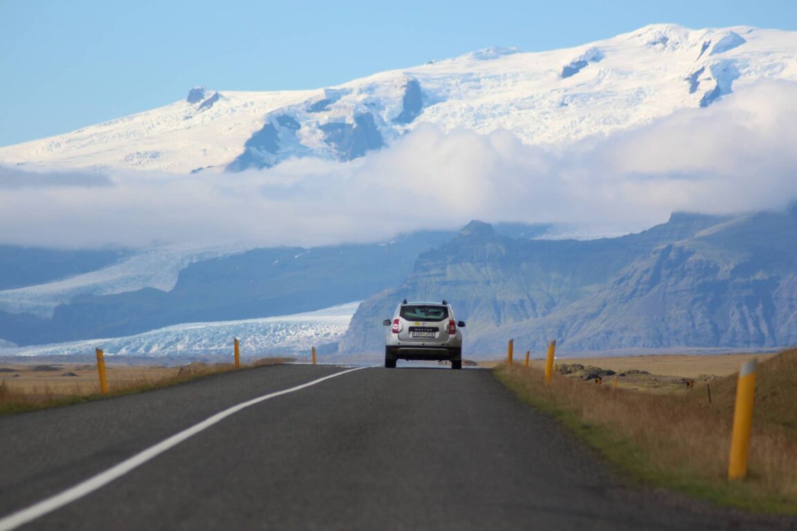
Featured image: A car on Iceland’s Ring Road driving toward the Vatnajokull ice cap on the south coast. Photo by Ferdinand Stohr on Unsplash, Unsplash License. Distances, charges and charging figures checked 18 November 2026 against Icelandic Road and Coastal Administration and operator sources.