 Sofia Rossi
Saint-Cirq-Lapopie is best walked early, end to end, before the day buses arrive: start at the river on the towpath from Bouzies, climb the stepped path into the village while the lanes are still quiet, work down the Rue Droite past the artists’ studios and the fortified church, and finish on the La Popie rock above the rooftops. By late morning the same lanes fill, so the order matters more here than the checklist. Stay for the evening if you can, because the village changes completely once the crowds leave and its own restaurants take over.
Quick Facts
- Where: Saint-Cirq-Lapopie, in the Lot department of Occitanie, about 30 kilometres east of Cahors, inside the Causses du Quercy regional natural park.
- What it is: A medieval cliff village above a meander of the River Lot, listed among the Most Beautiful Villages of France and voted the favourite village of the French in a national television vote in 2012.
- The towpath: The Chemin de Halage from Bouzies runs about 10 kilometres return to the village, with a shorter 3 kilometre return option to the Ganil lock, according to the Cahors Lot Valley tourist office.
- Parking: Bouzies car park is listed by the tourist office at 3 euros a day, with towpath access free.
- Best timing: Arrive on foot or by car before mid morning, or stay overnight and walk the village at dawn and again after dinner.
- Facts checked: 21 November 2026, against the Cahors Lot Valley tourist office and Lot Tourisme.
Why does the towpath from Bouzies make the best arrival?
Most visitors meet Saint-Cirq-Lapopie from a car park above the village, which puts them in the lanes at the same moment as everyone else. The river arrival reverses the experience. The towpath, the Chemin de Halage, follows the Lot from the port of Bouzies at water level, flat and shaded, with the cliff rising on one side and boats passing on the other in season. It is the route the river trade once depended on, and walking it explains the village before you ever reach it.
The engineering is the story. Where the cliff at the Ganil lock drops sheer into the river, the path had to be cut directly into the limestone in the 1840s, hollowed out for nearly a kilometre so that the horses towing the flat-bottomed gabarres upstream could keep walking. The tourist office describes the carved section as about 300 metres where the rock overhangs the path itself. Partway along, a bas-relief more than 30 metres long, carved into the limestone by the Toulouse sculptor Daniel Monnier in 1985 and again in 2019, picks out the life of the river: its fauna, its flora, its fossils and its whirlpools.
Practically, the walk divides neatly. The short version, from the Bouzies car park to the Ganil lock and back, is about 3 kilometres and under an hour, and it covers the carved cliff section that makes the path famous. The full version continues to the foot of Saint-Cirq-Lapopie, about 10 kilometres return from Bouzies, and ends with a stepped climb of roughly 10 to 15 minutes into the village. That climb is steep and the stone can be slippery after rain, so walking shoes rather than sandals are the right call, a point both the tourist office and Lot Tourisme make.
How should you walk the village itself, end to end?
Enter at the bottom and walk up, against the flow of the day groups who start at the top. The Porte de la Pelissaria, sometimes called the Rocamadour gate, is the best preserved of the old city gates, and the street it guards, the Rue de la Pelissaria, is lined with half-timbered houses whose ground floors once held the arcaded stalls of the skinners who gave the street its name. From there the Rue Droite, the old shopping street, climbs through the heart of the village.
On and around the Place du Sombral, the market square since the 13th century, stand the medieval bourgeois houses, arcaded and half-timbered homes from the 13th and 14th centuries whose upper floors were rebuilt in timber at the end of the 15th century. The House of the Fourdonne, now holding the town hall, opens onto a garden and open-air theatre along a pebble-paved lane. A few steps away, the Maisons Daura were the studio home of the Catalan painter Pierre Daura and now work as an international artists’ residence hosted by the Occitanie Region, one reason studios and small galleries still punctuate the lanes today.
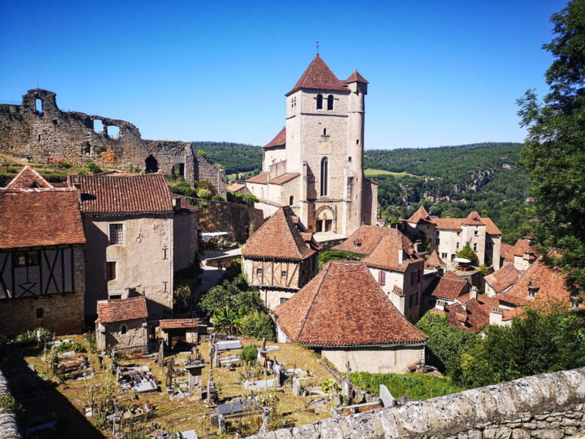
Keep climbing to the church, built from 1522 around the older Romanesque parish church and dedicated to Saint Cyr and his mother Sainte Julitte. Beside its fortified bell tower sits one of the old stone measures that once regulated grain sales in the market below, a small detail that ties the sacred building back to the trading village. Behind the church, terraces open over the valley, and the path continues to the Cardaillac castle ruins and then to the La Popie rock itself.
What is at the top of the La Popie rock?
The rock is the reason the village exists. Its name comes from the Occitan word for a breast-shaped promontory, and the first castle on the site was built here in the 10th century and rebuilt in the 12th. The fort above the village was later shared between three lordly families, the Lapopie, the Cardaillacs and the Gourdons, before being abandoned from the 17th century in favour of more comfortable houses below. What remains are the foundations of the master tower and the lordly dwelling, plus a belvedere below the summit that the tourist office singles out for views over the entire valley.
That view is the one to time carefully. In the early morning the Lot sits below in a long green curve, the towpath you walked is a pale line along the cliff, and the rooftops of the village stack beneath you in brown tile. It is also the moment to understand the village’s second famous trade. Saint-Cirq-Lapopie was a centre of woodturning, its craftsmen, the roubinetaïres, mass producing taps for the barrels that carried Cahors wine down this river, work that made the village name known across France long before tourism did.
Where do the artists fit into the village?
Twentieth-century artists adopted Saint-Cirq-Lapopie, and the village has kept that layer visible rather than tidying it away. The surrealist writer André Breton lived in the house that now bears his name, a fortified house with Gothic windows whose oldest parts date to the 13th century and whose tower is older still. It is listed as a Maison des Illustres and, together with the neighbouring Maison Rignault, a 15th-century fortified house restored by the art enthusiast Joseph Rignault, it now forms the International Center for Surrealism and Global Citizenship, the two houses linked by a footbridge and open as exhibition spaces.
The Rignault house also holds the village’s hanging gardens, terraces at the edge of the cliff with views straight down the Lot valley. Between the residency at the Maisons Daura, the Breton and Rignault houses and the working studios along the lanes, a slow walk reads as three villages layered together: the trading village of the river, the craftsmen’s village of the woodturners, and the artists’ village of the last century. If southern France’s layered villages appeal, the same reading works in Albi, where a cathedral and a painter’s museum anchor the Tarn, and the food-first version is in Lyon’s bouchons, explained dish by dish.
Where does the village eat after the crowds leave?
Day visitors eat where they land, usually near the square at peak hour. The better pattern is to walk first and eat later. Lunch after the towpath, once you have climbed into the village and the first rush has thinned, is calmer than lunch on arrival, and dinner is the meal that justifies staying overnight, when the lanes empty, the stone holds the day’s warmth and the restaurants serve the village itself as much as its visitors. Expect the cooking of the Lot: duck, walnuts, Cahors wine and the produce of the causses plateaus above the river.
Overnighting also solves the parking and timing problem in one move. Sleep in or near the village, walk the La Popie rock at dawn before any bus has left Cahors, spend the middle of the day on the river or at the prehistoric painted cave of Pech Merle in the neighbouring Cele valley, and return to the lanes in the late afternoon. The village rewards that rhythm more than any single sight in it.
Frequently Asked Questions
How long does the towpath walk from Bouzies take?
The tourist office gives about 3 kilometres return for the walk to the Ganil lock and about 10 kilometres return for the full walk to Saint-Cirq-Lapopie, plus a stepped climb of 10 to 15 minutes into the village. Allow half a day for the full version with stops.
When was Saint-Cirq-Lapopie voted France’s favourite village?
The village won the national television vote for the favourite village of the French in 2012, and it is also listed among the Most Beautiful Villages of France. It has 13 listed historic monuments in a village of roughly 200 residents.
Can you swim in the Lot at Saint-Cirq-Lapopie?
Yes, in season. The village has an arranged bathing area at the boating stop below the village, with water quality controlled daily in summer and supervised bathing on July and August afternoons, according to local listings.
What is the best way to avoid the crowds?
Arrive on foot by the towpath in the morning, or stay overnight. The lanes are quietest before mid morning and again in the evening after the day groups have left for Cahors and Figeac.
Featured image: Saint-Cirq-Lapopie above the Lot, France. Photo by F. Laparra, Tourist Office Cahors Lot Valley, via the Cahors Lot Valley tourist office (cahorsvalleedulot.com), the village’s own official tourism authority, used with credit. Facts checked 21 November 2026.