 River Callahan
Zagori reduces to a workable circuit when you stop trying to see all 46 stone villages and instead build three linked days: a Papingo day under the Astraka towers with the rock pools between the two villages, a gorge day split between the Oxya lookout above Monodendri and the full traverse only if you are fit for it, and a bridges day around Kipi and Koukouli ending at the triple-arched Plakidas bridge. Base in Papingo or Monodendri, drive slowly, and let the stone villages come in clusters rather than as a checklist.
Quick Facts
- Where: Zagori, or the Zagorochoria, in Epirus in northwestern Greece, roughly 30 to 60 kilometres north of Ioannina in the Pindus mountains.
- What it is: 46 stone-built villages inscribed as the Zagori Cultural Landscape on the UNESCO World Heritage List in 2023, according to the Region of Epirus tourism authority.
- The gorge: The main Vikos Gorge runs about 12 kilometres, reaching about 1,000 metres deep, through the core of the Vikos-Aoos National Park.
- Getting there: About one hour by car from Ioannina, whose airport has flights from Athens. A car is close to essential, as public transport is limited.
- Best seasons: April to June and September to October for hiking, per the Epirus tourism authority. Drakolimni climbs suit June to October.
- Facts checked: 21 November 2026, against This is Epirus, the Region of Epirus official tourism site, and UNESCO.
How do Zagori’s three clusters divide the trip?
Zagori is not one place but three, and the map makes sense once you name them. Central Zagori, around Monodendri, Kipi and Koukouli, holds the famous bridges and the southern rim of the Vikos Gorge. West Zagori holds Megalo and Mikro Papingo under the cliffs of Mount Tymfi, plus Aristi and Vikos village at the gorge’s northern end. East Zagori, around Tsepelovo, Skamneli and Vrisochori, is wilder, higher and less visited. Most first trips should weight the first two clusters and treat the east as a fourth day, not as a detour squeezed into a gorge day.
The villages share one architectural language, which is the point of the UNESCO listing. Each is built of local grey stone, houses of two or three storeys with slate roofs, arranged around a central square, the mesochori, with a church, a plane tree and a fountain. Many were funded by Zagori merchants who made money abroad in the 18th and 19th centuries and sent it home for schools, roads and bridges, which is why a thinly populated mountain district, around 3,400 residents today, carries infrastructure far grander than its size suggests.
Why start in Papingo, and what are the rock pools?
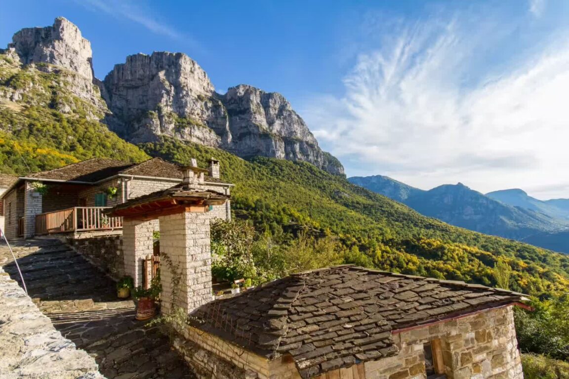
Megalo Papingo and Mikro Papingo, a few minutes apart on the same road, sit beneath the vertical limestone walls of the Astraka towers, and they are the best hiking base in Zagori. Mikro Papingo is the trailhead for the climb to the Astraka refuge and on to Drakolimni, the Dragon Lake of Tymfi, a full and demanding day at around 2,050 metres that the Epirus authority places in the June to October window. Megalo Papingo holds the larger choice of stone guesthouses and tavernas, and both villages are small enough to cross on foot in minutes once you have parked.
Between the two villages, a short walk from the road, the Rogovos stream has carved the Ovires, the Papingo rock pools, a chain of smooth natural basins in the limestone. In summer the pools are cold, clear and irresistible after a walk, and local practice deepens them slightly with small seasonal dams. Go early in the day in July and August, wear shoes that grip wet rock, and treat the pools as a swim stop between hikes rather than a destination that fills a day. From Papingo the road also drops to the Voidomatis springs and the river, whose water is famously cold and clear, and rafting trips run from the Aristi bridge for about an hour and a half, according to the regional authority.
Oxya or Beloi: which Vikos Gorge lookout should you choose?
Oxya is the drive-up answer. A road of about 8 kilometres from Monodendri ends at a viewpoint over the deepest part of the gorge, where the walls drop more than 900 metres and the canyon narrows to about 1,100 metres across, the proportion that earned Vikos its Guinness listing as the deepest gorge in the world relative to its width. There is a short walk from the car park to the platform, and the viewpoint has limited protection at the edge, so keep well back and supervise children closely.
Beloi is the walking answer. Reached by a path of roughly 20 to 30 minutes from the village of Vradeto, it looks along the gorge from the eastern side and rewards the effort with the quieter, wider view. Vradeto itself is part of the story: until a road opened in 1974, the village was reached only by the Vradeto Steps, a long stone stairway built in the 18th century, which walkers can still descend toward Kapesovo. Choose Oxya on a first day or with limited mobility in the group, Beloi when you have a spare half day, and both if viewpoints are your reason for coming.
Monodendri, the village below Oxya, deserves its own hour. A stone path leads from the square to the Monastery of Agia Paraskevi, built at the edge of the cliff in the early 15th century, with a terrace over the gorge and a narrow ledge path beyond it that is not for anyone with vertigo. Monodendri is also the southern trailhead of the classic gorge traverse, about 12 kilometres along the gorge floor to Vikos village, a six to seven hour one-way walk with about 1,000 metres of descent and climb. There is no public transport between Vikos village and Monodendri, so arrange a taxi back before you start, carry all your water and food, and do not attempt the traverse in storm weather or after heavy rain.
Where do the arched bridges fit into the circuit?
The bridges day belongs to Central Zagori, around Kipi and Koukouli, where the greatest concentration of stone bridges survives. These single and multi-arched bridges were built mostly in the 18th and 19th centuries by travelling stonemasons and paid for by local benefactors, so that mule trains could cross the winter torrents between villages. The regional authority names Kokkori, Kalogeriko and Kontodimou among the finest, all in the Kipi cluster.
The star is the Plakidas bridge, also called Kalogeriko, just outside Kipi on the road toward Koukouli. Built in 1814, its three arches step across the stream in a rising curve that makes it the most photographed bridge in Zagori, and it is an easy, short walk from the road. Pair it with the single-arched Kokkori bridge nearby, then finish in Koukouli or Dilofo, two of the quietest and best preserved villages, for a late lunch. The bridges work in any weather and in winter, which makes this the flexible day to swap in when cloud closes the gorge lookouts.
How many nights does Zagori actually need?
Three nights is the honest minimum: one day for Papingo and the pools, one for the gorge rim or traverse, one for the bridges and Central Zagori. Four or five nights lets you add Drakolimni, the Voidomatis rafting and an East Zagori village such as Tsepelovo without turning the trip into driving. A day trip from Ioannina shows you one lookout and one village and misses the point, which is the slow rhythm of the squares in the evening. Travellers combining Zagori with classical Greece can pair it with Delphi, visited in the right museum and sanctuary order, and the food writing from the north is in Thessaloniki’s table, from bougatsa breakfasts to the Modiano Market.
Eat where you sleep whenever you can. Zagori cooking is mountain cooking: handmade pies, local cheeses, mushrooms, slow-cooked meat, tsipouro and spoon sweets, served in tavernas on the village squares. Bring cash, because ATMs are few, fill the car with fuel before leaving Ioannina, and pack layers even in summer, since the regional authority puts summer evenings firmly in fleece territory at this altitude.
Frequently Asked Questions
How many villages are there in Zagori?
There are 46 stone villages, the Zagorochoria, split between East and West Zagori. The Zagori Cultural Landscape was inscribed on the UNESCO World Heritage List in 2023.
Do you need a car in Zagori?
Yes, in practice. The Region of Epirus tourism authority states that your own vehicle is almost essential for moving between the villages, as public transport is limited. The nearest airport is Ioannina, about an hour away by road.
How long does the Vikos Gorge traverse take?
The classic one-way walk from Monodendri to Vikos village is about 12 kilometres and takes roughly six to seven hours, with no public transport at the far end. Arrange a taxi return in advance and carry all water and food.
When is the best time to visit Zagori?
Spring, April to June, and autumn, September to October, are ideal for hiking, with summer best for the rock pools and rafting and winter quiet and snowy, according to the Epirus tourism authority.
Featured image: Papingo village in Zagori, Greece, stone houses beneath the Astraka towers. Photo via This is Epirus (thisisepirus.gr), the Region of Epirus official tourism authority, the subject’s own official tourism site, used with credit. Facts checked 21 November 2026.