 James Wolfe
Base in Runavik if you want the Faroe Islands with the logistics already solved: a harbour town on Eysturoy, the second largest island, plugged straight into Torshavn by the undersea tunnel with the worlds first undersea roundabout, and within an easy drive of Gjogv, the northern village whose sea filled gorge is the single most satisfying short trip in the archipelago. Runavik is not the prettiest town in the Faroes. It is the most useful one, and in islands where weather and distance decide everything, useful wins.
Quick Facts
- Where: Runavik sits on the eastern shore of Skalafjordur on Eysturoy, the second largest of the Faroe Islands, north of Torshavn.
- Best for: Road trippers, photographers, and travellers who want one fixed base for the northern islands.
- Headline sights: Gjogv and its natural harbour gorge, the Eysturoyartunnilin undersea roundabout, Risin og Kellingin sea stacks near Eidi, Funningur, and the Skalafjordur shore towns.
- Time needed: Two nights minimum in Runavik. Three lets the weather have a say without ruining the plan.
- Getting around: A rental car is close to essential. The tunnel makes Torshavn a short drive rather than an expedition.
- Do not miss: Gjogv in the evening, when the day cars have gone and the gorge belongs to the village again.
How did the tunnel change Eysturoy?
On 19 December 2020 the Eysturoyartunnilin opened, and the geography of the Faroes quietly changed. The tunnel network runs 11.24 kilometres in three branches beneath the fjord, meeting at a roundabout 72.6 metres below the surface, the first undersea roundabout anywhere in the world, lit and decorated with artwork by the Faroese artist Trondur Patursson. At its deepest the road passes 189 metres below sea level. The effect, as the Eysturoy Tunnel record sets out, was to cut the journey between Torshavn and Runavik from 55 kilometres to 17, and from over an hour to roughly a quarter of an hour.
For visitors the consequence is simple. Runavik and the shore towns along Skalafjordur now function as a suburb of the capital for access, while keeping a working harbour towns own life: fish industry, local shops, and a waterfront that serves residents first. Tolls apply and are handled through the tunnil.fo system, with registration cheaper than paying as an unregistered driver, so sort the car paperwork on day one. From Runavik, the whole of Eysturoy, and road connections onward to the northern islands, open up without a single ferry timetable governing your day. That freedom is the context for everything in our wider Faroe Islands travel guide.
Why is Gjogv the day trip that justifies the base?
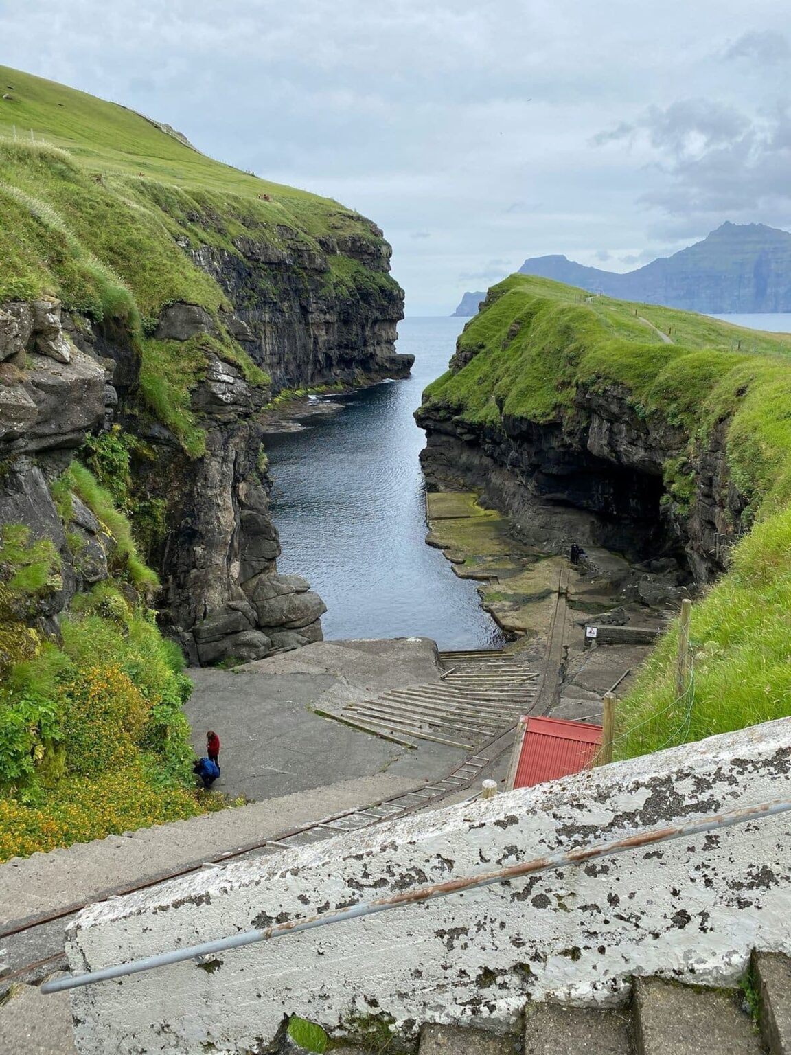
Gjogv, at the north eastern tip of Eysturoy about 63 kilometres by road from Torshavn, is the Faroes in miniature: a few dozen residents, colourful houses, a grass roofed stillness, and a 200 metre sea filled gorge cutting inland from the Atlantic that serves as the villages natural harbour, with a ramp and rails where boats are hauled clear of the water. The village takes its very name from that gorge. Walk the path above it for the full composition, gorge in the foreground, the island of Kalsoy across the water, and the cliffs running away north.
The details reward a slow visit rather than a photo stop. The village church dates from 1929 and holds a particular place in Faroese history as the first church consecrated in the village, with services in Faroese. A memorial by the road remembers fishermen lost at sea, a mother and children looking out over the water. The guesthouse and cafe make Gjogv a realistic lunch or overnight pause, but from Runavik it works best as the long evening excursion: drive up through Funningur, one of the oldest settlements in the islands with its traditional wooden church above the fjord, arrive as the light softens, and drive back under a sky that, in summer, never fully darkens. The Gjogv village guide fills in the harbour, trails and amenities for travellers planning that run.
What else does an Eysturoy base unlock?
Start close. The Skalafjordur shore itself, Runavik through Toftir and Strendur, is an easy half day of harbour towns, fjord views and the tunnel roundabout as a sight in its own right, the only traffic junction most travellers will ever photograph. Head north west and Eidi gives the classic shore view of Risin og Kellingin, the Giant and the Witch sea stacks standing off the coast, best seen from the Eidi side in clear weather, with the villages football pitch turned campsite on the cliff edge nearby telling its own story about Faroese priorities. Slaettaratindur, the highest peak in the Faroes, rises above this same northern country and draws walkers in settled weather, though its summit is a fair weather promise only: in the Faroes the mountain decides, not the itinerary.
The base logic extends beyond one island. With Torshavn a short tunnel drive away, the capital becomes an evening option rather than a competing base, and road linked islands to the north become day trips instead of ferry puzzles. Travellers building a longer North Atlantic route can pair this practical base with the wilder single island stays in our Lofoten Islands guide, two very different answers to the same northern light.
When should you go, and what can go wrong?
Late spring to early autumn is the working season: the most daylight, the best odds on the northern roads, seabirds on the cliffs and every cafe and guesthouse open. Winter in Runavik is a locals town in the dark, atmospheric for a night around the tunnel and the capital, but no basis for a Gjogv centred trip. The standing Faroes warnings apply everywhere on Eysturoy and deserve repeating plainly. Weather changes by the hour and can close exposed roads while the tunnel stays open. Book the car early, since rental fleets are small. And keep one spare half day in the plan: the traveller who schedules Gjogv for a single fixed afternoon is gambling, while the traveller based in Runavik for three nights simply goes tomorrow instead.
Frequently Asked Questions
Is Runavik worth staying in, or just passing through?
Stay. It has the harbour town services, the tunnel on its doorstep and the whole of Eysturoy within easy reach. It trades postcard looks for the best logistics in the northern Faroes.
How long is the drive from Torshavn to Runavik?
About 17 kilometres through the Eysturoyartunnilin, roughly 15 to 16 minutes, compared with 55 kilometres and over an hour before the tunnel opened in December 2020.
What is special about the Eysturoy tunnel?
Its three branches total 11.24 kilometres and meet at the worlds first undersea roundabout, 72.6 metres below the fjord, with the road reaching 189 metres below sea level at its deepest.
How do you get to Gjogv from Runavik?
By road north through Eysturoy, passing Funningur, in about an hour depending on weather and photo stops. Gjogv sits 63 kilometres by road from Torshavn at the islands north eastern tip.
What is there to see in Gjogv?
The 200 metre sea filled gorge that forms its natural harbour, the 1929 church, the memorial to fishermen lost at sea, and cliff paths with views across to Kalsoy.
Do you need a car on Eysturoy?
Realistically, yes. Buses exist but are built around local and school timetables. A rental car turns Gjogv, Eidi and the northern villages into simple day trips from Runavik.