 Jonas Lindqvist
As of November 21, 2026, there is no eruption under way on the Reykjanes Peninsula, and there is no open eruption viewing area to drive to. The Icelandic Meteorological Office, in its most recent Reykjanes update dated November 10, 2026, reports continued ground uplift at Svartsengi as magma accumulates underground, and it still judges a new magma intrusion, which could lead to an eruption on the Sundhnukur crater row north of Grindavik, to be the most likely scenario. The last eruption, the ninth on that crater row, ran from July 16 to August 5, 2025. The practical rules for a traveller with a rental car from Keflavik are therefore two sets at once: the standing rules for the older, visitable Fagradalsfjall lava fields, and the closure rules that snap into force around Sundhnukur the moment a new fissure opens, sometimes with as little as 20 minutes of warning.
Quick Facts
- Status, November 21, 2026: No eruption in progress on Reykjanes; the ninth Sundhnukur eruption ended on August 5, 2025, per the Icelandic Meteorological Office
- Alert level: Reykjanes and Svartsengi volcanic system at level 2 (orange); hazard map issued September 30, 2026, valid until January 5, 2027 unless conditions change
- Magma: About 29.1 million cubic metres accumulated beneath Svartsengi since the July 2025 eruption began, per Met Office modelling reported in August 2026
- Warning time: Before earlier eruptions on the crater row, warning ranged from about 20 minutes to just over four hours; do not count on more
- Closed ground: The Sundhnukur crater row area is closed to the public; walking on new lava is banned everywhere
- Open ground: The cooled Fagradalsfjall fields from the 2021 to 2023 eruptions, on marked trails from car parks P1 and P2 on Road 427
- Parking: 1,000 ISK per car per day at the Fagradalsfjall car parks, paid electronically through Parka; pay within 24 hours to avoid a surcharge
- Checks before driving: vedur.is for eruption status, safetravel.is for travel alerts, road.is for live road closures, visitreykjanes.is for eruption site news
- Facts checked: November 21, 2026, against Icelandic Meteorological Office reporting and official Icelandic visitor sources
Is a volcano actually erupting on Reykjanes right now?
No, and any article or social post implying a live eruption to watch this week is out of date. The sequence that matters runs like this. The Sundhnukur crater row, between Grindavik and the Blue Lagoon, has produced nine eruptions since December 2023. The ninth began on July 16, 2025 and ended on August 5, 2025, and nothing has erupted since. What continues is the build up: the Icelandic Meteorological Office update of November 10, 2026 describes steady ground uplift at Svartsengi, very low seismic activity, and a magma reservoir that its modelling put at about 29.1 million cubic metres in August 2026, the largest volume of the series so far. The office is explicit that the timing of the next event cannot be predicted, that a long pause is not evidence the episode has ended, and that clear signs cannot be expected in the days before an eruption starts.
That combination, quiet surface, loaded system, short warning, is the whole reason the viewing rules exist in their current form. The Reykjanes and Svartsengi system sits at alert level 2 (orange) on the Met Office scale. On the hazard map issued September 30, 2026 and valid until January 5, 2027, Grindavik falls in the considerable hazard category and Svartsengi, where the Blue Lagoon sits, in the moderate category. Grindavik itself is open and under the Civil Protection uncertainty phase, with no evacuation in force at the time of writing, but the town and the lagoon are both cleared as a precaution when an eruption begins, as they were in July 2025. Treat every status in this article as a snapshot dated November 21, 2026, and recheck it on the morning of any drive toward the peninsula’s south coast.
Which eruption areas are closed, and which can you still walk?
The Sundhnukur crater row is closed to the public, full stop. That is the ground of the nine eruptions since December 2023, directly north of Grindavik and a few kilometres east of the Blue Lagoon, and there is no viewing platform, trailhead or official vantage for it. Closures around an active or recent eruption site are ordered by the Suðurnes police commissioner together with Civil Protection, they are enforced on the ground, and the ban on stepping onto new lava applies everywhere on the peninsula: a cooled crust can be thin over molten or near molten rock, and it is the single most repeated warning in every official source.
The visitable eruption landscape is the older one. Fagradalsfjall, a few kilometres east, holds the cooled lava fields of the 2021, 2022 and 2023 eruptions, including the 2023 crater at Litli-Hrutur, and it is open on marked trails from car parks P1 and P2 off Road 427, the Suðurstrandarvegur south coast road. Visit Reykjanes and Visit Iceland lay out the route options: the short Natthagi trail of about 2 kilometres to the edge of the 2021 lava, Path C of about 4 kilometres one way to a viewpoint over all three Fagradalsfjall eruptions, Path A of 6 to 8 kilometres one way toward the 2021 and 2022 craters, and Path E, the long 18 to 20 kilometre round trip to Litli-Hrutur that takes five to six hours of walking before viewing time. There is no service of any kind at the trailheads, no scheduled bus to the car parks, and the trails are gravel and lava rock rather than boardwalk, so the short options are the realistic choice in November daylight and weather.
Which roads close, and how does the Keflavik drive actually work?
Start with the reassurance the record supports: Reykjanesbraut, Road 41 between Keflavik Airport and Reykjavik, has stayed open through the eruptions of this series, the eruptions are effusive lava events rather than ash events, and they have not closed Keflavik Airport. The closures concentrate on the small road net around Grindavik and the Blue Lagoon. Road 43, Grindavikurvegur, the turning off Road 41 about 12 kilometres from the airport terminal, was crossed by lava several times in 2024, in February, May and November, and sections were rebuilt over the new lava; during eruptions it has been closed at Seltjorn and at times opened only to travellers with a booking in the Svartsengi area. Road 426, the Blue Lagoon access road, has also gone under lava in places. Neither fact can be converted into a prediction for your dates, which is why the live source is the only source: check the Road Administration map at road.is on the morning you drive, and again before the return leg.
Two driving rules follow from how these eruptions behave. First, never stop on Road 41 or any live road to watch or photograph activity; the airport road carried explicit do not stop requests during past eruptions, and a new eruption raises police presence across the whole corner of the peninsula. Second, build the south coast leg as a flexible block, not a fixed appointment. If a fissure opens while you are in Iceland, the Fagradalsfjall trails can also close at short notice, the Blue Lagoon can evacuate, and the correct response is to follow Safetravel alerts and police direction rather than a plan made at the rental desk. Travellers pairing the peninsula with a lagoon soak can compare the two big options in our Sky Lagoon versus Blue Lagoon guide, and anyone driving onward in winter should read our Iceland winter packing system before relying on daylight that November does not provide.
How do parking and access work at the Fagradalsfjall trailheads?
Parking is in the designated car parks only, P1 and P2 on Road 427 east of Grindavik, and parking along Road 427 itself is forbidden. The fee is 1,000 ISK per car per day, paid electronically through Parka: enter the registration plate and pay within 24 hours of leaving, because late payment attracts a surcharge, listed at 1,960 ISK in current visitor guidance. There is no entry fee, permit or booking for the trails themselves, and no shuttle system to learn in the current quiet period: the parking and shuttle arrangements travellers may remember from the 2021 eruption crowds belonged to an active eruption with a managed viewing area, and no equivalent operation exists while nothing is erupting. If a new eruption produces an official viewing area, it will be announced through Safetravel and Visit Reykjanes with its own parking and access rules, and those announcements, not older eruption coverage, are the ones to follow.
The safe distance rules on the open trails are simple and absolute. Stay on the marked paths, keep off all new lava including the youngest Fagradalsfjall flows where signs close them, respect any gas warning in force, because volcanic gas pools in hollows and the Met Office publishes gas dispersion forecasts during eruptions, and turn back in wind or fog rather than navigating lava fields by phone light. Leave a travel plan at Safetravel before any long trail, carry food and water from Grindavik, and treat the five to six hour Litli-Hrutur round trip as a summer undertaking rather than a November one. In the current pause, the honest version of volcano viewing on Reykjanes is a walk through the newest landscape in Iceland with a live status check before it, and that is still a remarkable thing to be able to do 30 minutes from the airport.
Frequently Asked Questions
Is there an active volcano eruption in Iceland today?
No. As of November 21, 2026, no eruption is under way on the Reykjanes Peninsula. The last eruption, the ninth on the Sundhnukur crater row, ended on August 5, 2025. The Icelandic Meteorological Office reports continued uplift at Svartsengi and judges a new magma intrusion that could lead to an eruption to be the most likely scenario, with no predictable date.
Can you still see lava fields on Reykjanes without an eruption?
Yes. The cooled lava fields of the 2021 to 2023 Fagradalsfjall eruptions, including the 2023 Litli-Hrutur crater, are open on marked trails from car parks P1 and P2 on Road 427. Options run from the roughly 2 kilometre Natthagi trail to the 18 to 20 kilometre round trip to Litli-Hrutur. The Sundhnukur crater row near Grindavik remains closed to the public.
How much is parking at the Fagradalsfjall eruption trails?
Parking at the P1 and P2 car parks costs 1,000 ISK per car per day, paid electronically through Parka. Pay within 24 hours of leaving to avoid a surcharge. The trails themselves have no entry fee or permit, and parking on Road 427 outside the designated car parks is forbidden.
Will a Reykjanes eruption cancel flights at Keflavik?
The eruptions of this series have not closed Keflavik Airport or stopped flights. They are effusive lava eruptions rather than ash producing explosions, and their effects have been local: road closures and evacuations around Grindavik and the Blue Lagoon. Check your airline and the airport departures board on the day, as with any disruption.
What should you check on the morning of a Reykjanes drive?
Four official sources: vedur.is for the eruption status and hazard assessment, safetravel.is for travel alerts, road.is for live closures on Roads 41, 43 and 427, and visitreykjanes.is for eruption site and trail news. Warning times before past eruptions ranged from about 20 minutes to just over four hours, so a morning check is a minimum, not a guarantee.
Is Grindavik open to visitors?
Yes, at the time of writing. Grindavik has been freely accessible again since October 2024 and sits at the Civil Protection uncertainty phase, with visitors advised to stay on paths and note evacuation routes. The town and the Blue Lagoon are evacuated as a precaution when an eruption starts, so its open status is one of the first things to recheck.
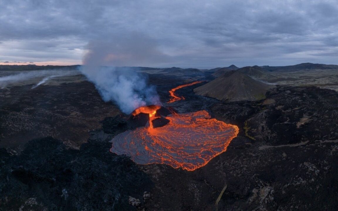
Featured image: The Litli-Hrutur eruption on the Reykjanes Peninsula, lava fountaining from the crater and spreading across the new lava field in the Fagradalsfjall area. Photo from Visit Reykjanes (visitreykjanes.is), the official regional visitor authority, used with credit.