 Sofia Rossi
Fort Davis works best as a story you walk in daylight and finish after dark. Start at Fort Davis National Historic Site, where the parade ground, Officers Row and the furnished barracks still lay out a frontier Army post almost exactly as soldiers left it in 1891, then drive 16 miles up Highway 118 to the McDonald Observatory for a Star Party under some of the darkest skies in the continental United States, and give the 75 mile Davis Mountains Scenic Loop a full morning in between. The fort is open daily from 8 a.m. to 5 p.m. Central Time and costs $20 per vehicle for a seven day pass, the observatory program runs about two hours and costs $5 to $25 per person by age group, and both need to be planned rather than improvised, because the fort closes at five and Star Parties frequently sell out.
Quick Facts
- Where: Fort Davis, Jeff Davis County, West Texas, in the Davis Mountains. Park address: 101 Lt. Flipper Drive, Fort Davis, TX 79734. Phone 432 426 3224.
- The fort: Fort Davis National Historic Site, one of the best surviving examples of an Indian Wars frontier military post in the Southwest, active from 1854 to 1891 with a Civil War break.
- Fort hours: Grounds open 8 a.m. to 5 p.m. Central Time daily. Visitor center open 8 a.m. to 4:30 p.m. Closed Thanksgiving Day, Christmas Day, New Year’s Day and the Martin Luther King Jr. holiday.
- Fort entry: $10 per person, $20 per vehicle or $15 per motorcycle, each valid seven days. Children 15 and under are free. The Fort Davis annual pass costs $35 and interagency passes are honored.
- Time needed: The Park Service suggests one and a half to two hours for the fort. The self guided visit starts with a 15 minute orientation film at the visitor center.
- The observatory: McDonald Observatory, a research facility of the University of Texas at Austin, 16 miles northwest of Fort Davis on Highway 118. Frank N. Bash Visitors Center, 3640 Dark Sky Drive, phone 432 426 3640.
- Star Party: About two hours, all ages, general admission included, $5 to $25 per person depending on age group. Book in advance through the observatory website; programs frequently sell out.
- Visitors center hours: The observatory visitors center is open Tuesday to Saturday, noon to 5 p.m., and closed Sunday and Monday.
- The drive: The Davis Mountains Scenic Loop is a 75 mile circuit through the Davis Mountains past the state park, the observatory, Mount Livermore and Sawtooth Mountain.
- Altitude: The fort sits at 4,856 feet. The observatory visitors center sits at about 6,235 feet, and parts of its programs reach about 6,300 feet.
- Sleeping: There is no lodging or camping inside the historic site. Lodging is in the town of Fort Davis, and camping is available in town and at Davis Mountains State Park, four miles west.
- Facts checked: 18 November 2026, against the National Park Service Fort Davis pages and the McDonald Observatory official visitor pages.
Why does a frontier fort still stand this complete in West Texas?
The order that created Fort Davis was issued on 23 October 1854, and the post was named for Jefferson Davis, then the United States Secretary of War. Its job was practical rather than glamorous: to protect emigrants, mail coaches and freight wagons crossing the Trans Pecos on the San Antonio to El Paso Road and on the Chihuahua Trail, in country the Park Service describes through the campaigns of the Indian Wars era. The first fort, built from 1854 beside Limpia Creek at the mouth of a sheltered canyon, was abandoned during the Civil War. When the Army returned in 1867 it rebuilt on a larger scale, and that second fort is the one a visitor walks today, a post that stayed in service until 1891.
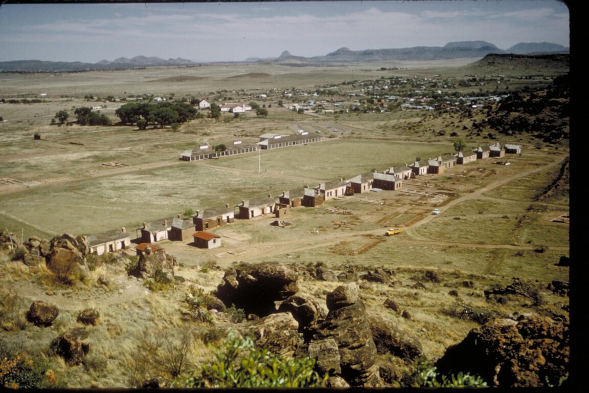
What makes Fort Davis unusual is survival rather than size. The Park Service calls it one of the best surviving examples of an Indian Wars frontier military post in the Southwest, and the ground plan explains why. A broad parade ground anchors the site. Officers Row lines one side. Enlisted mens barracks, a hospital, storehouses and service buildings fill out the post, some restored and refurnished to the 1880s, others standing as ruins and foundations. The Park Service counts more than 100 ruins and foundations alongside the restored buildings, so the visit reads as a whole town plan rather than a single museum building. Allow the full two hours the park suggests, because the scale only makes sense on foot.
What do you actually see on the self guided walk?
Begin at the visitor center and museum, which sits inside the historic post and is the place to pay the entrance fee, pick up the grounds map and watch the 15 minute orientation film, shown every half hour. From there the self guided route moves through the furnished buildings, where period rooms show how officers, enlisted men and the post hospital actually functioned day to day. During summer months and spring break, interpreters in period clothing are stationed in some of the buildings, and the park layers sound over the grounds as well: bugle calls sound across the post, and an audio presentation of an 1875 dress retreat parade plays at scheduled times, listed by the park at 11 a.m., 2 p.m. and 4 p.m.
Two threads give the walk its weight. The first is the story of Black soldiers in the frontier Army. After the Act of 1866 gave African Americans a permanent place in the United States armed forces, Black regiments served at Fort Davis in the post Civil War decades, and the street the visitor center stands on is named for Second Lieutenant Henry O. Flipper, born into slavery in Georgia in 1856 and the first African American graduate of West Point. The second thread is the trail network. The park maintains about four miles of hiking trails, including a climb to an overlook above the fort and routes that connect with the trails of Davis Mountains State Park next door, so a history visit can end with the single best view of the parade ground layout, from above. Pets on a leash are permitted in the park, and a Junior Ranger program is open to all age groups.
For wider desert park context before a West Texas trip, compare how other Park Service sites structure a first visit in our Capitol Reef first timer guide and our guide to the Needles District of Canyonlands, both built the same way, around the one walk that explains the place.
How does the McDonald Observatory Star Party work?
Sixteen miles northwest of town, Highway 118 climbs to the McDonald Observatory on Mount Locke, a working research facility of the University of Texas at Austin that has operated since 1939. Every visitor checks in at the Frank N. Bash Visitors Center, and the Star Party is its signature public program: an outdoor evening of about two hours that begins with an introduction in the amphitheater as the sky darkens, continues with a guided constellation tour of about 30 to 45 minutes, and finishes with roughly an hour of viewing through a row of telescopes ranging from 8 to 22 inches in aperture. The objects change with the season and can include planets, galaxies, star clusters and nebulae. One boundary is worth knowing before you book: guests do not look through the large research telescopes, which stay reserved for science work.
Tickets cost $5 to $25 per person depending on age group, general admission is included, and members receive one to six complimentary passes a year depending on membership level. The observatory is blunt about demand: Star Parties frequently sell out in busy periods such as spring break and major holidays, and even an average night can draw about 300 people, so advance reservation through the official site is the only sensible plan. Check in opens one hour before the program and the observatory asks guests to arrive at least 15 minutes early. Practical details matter at this altitude. The program involves some walking at about 6,300 feet, seating is on stone benches, so a pad or blanket helps, and clothing needs to be warmer than the Texas desert stereotype suggests: from fall through early spring temperatures at the program can fall into the 30s Fahrenheit or colder, and even summer nights can require a jacket. In summer the start can be as late as nearly 10 p.m., because the observatory sits far west in the Central Time zone and sunset comes almost an hour later than in Houston. If weather threatens the sky, staff contact ticket holders by email with options, and cloudy nights switch to indoor programs such as a virtual sky tour or dome tours. There is no public food service at the observatory, though picnic tables at the visitors center are open to guests, so dinner belongs in Fort Davis before the drive up.
Readers who plan trips around dark skies specifically may also want our Atacama Desert stargazing guide, which uses the same logic as Fort Davis: a high, dry, remote site, a guided program, and warm layers treated as essential equipment rather than an afterthought.
What does the Davis Mountains Scenic Loop add?
The loop is the piece that turns two attractions into a place. The Park Service describes it as a 75 mile drive through the Davis Mountains that passes Davis Mountains State Park and Indian Lodge, the McDonald Observatory and the historic site itself, with views of Mount Livermore at 8,382 feet, the highest summit in the Davis Mountains, and Sawtooth Mountain at 7,746 feet, plus the Rock Pile formation and a large picnic area in Madera Canyon. Driven with stops, it fills a morning comfortably and explains the geography the fort depended on: a volcanic mountain island rising out of the Chihuahuan Desert, high enough to catch water, grass and cooler air, which is exactly why a supply road, and then a fort, made sense here.
Two side stops round out the circuit. Davis Mountains State Park, four miles west of Fort Davis on Highway 118, holds the camping the historic site lacks, along with trails, an interpretive center and the pueblo style Indian Lodge inside the park. Four miles south of town on Highway 118, the Chihuahuan Desert Research Institute adds the botany: an arboretum of regional trees and shrubs and a greenhouse holding more than 240 species of Chihuahuan Desert cacti and succulents. Fort Davis also works as a staging town for longer West Texas drives, since Big Bend National Park lies about 130 miles away and Guadalupe Mountains National Park about 160 miles away by the Park Service’s own nearby attractions guide, but neither is a casual add on to a fort day. Give Fort Davis its own overnight instead, with the Star Party as the fixed point, the fort the following morning before the heat builds, and the loop as the slow drive out. The Fort Davis Chamber of Commerce, at 800 524 3015 and fortdavis.com, is the parks listed source for town lodging and restaurant information.
Frequently Asked Questions
How much does Fort Davis National Historic Site cost, and when is it open?
Entry costs $10 per person, $20 per vehicle or $15 per motorcycle, each valid for seven days, and children 15 and under enter free. A Fort Davis annual pass costs $35. Grounds are open daily from 8 a.m. to 5 p.m. Central Time and the visitor center from 8 a.m. to 4:30 p.m., with closures on Thanksgiving Day, Christmas Day, New Year’s Day and the Martin Luther King Jr. holiday.
How do I book a McDonald Observatory Star Party, and what does it cost?
Book in advance on the McDonald Observatory official website. Tickets run $5 to $25 per person depending on age group and include general admission. The program lasts about two hours, check in opens one hour before it starts, and the observatory advises arriving at least 15 minutes early. Book early for spring break and holidays, when programs frequently sell out.
Can I visit the fort and the observatory on the same day?
Yes, and that is the natural pairing. The fort closes at 5 p.m. and the observatory is 16 miles northwest on Highway 118, so a morning or early afternoon fort visit, dinner in town, and an evening Star Party fit one day without rushing. Note that the observatory visitors center is closed on Sunday and Monday, while the fort is open daily apart from its four holiday closures.
How long is the Davis Mountains Scenic Loop, and what will I see?
The loop is a 75 mile drive through the Davis Mountains, passing Davis Mountains State Park, the McDonald Observatory and the historic site, with views of Mount Livermore at 8,382 feet and Sawtooth Mountain at 7,746 feet and a picnic area in Madera Canyon. Driven without stops it takes roughly two hours; with the state park and picnic stops, allow a morning.
Where do I stay or camp near Fort Davis?
There is no lodging or camping inside the historic site. Lodging and restaurants are in the town of Fort Davis, and camping is available in town and at Davis Mountains State Park, four miles west on Highway 118, which also contains the pueblo style Indian Lodge. The Fort Davis Chamber of Commerce lists town options.
What should I wear for a Star Party?
More than you expect. The observatory warns that from fall through early spring temperatures during the program can be in the 30s Fahrenheit or colder, and summer nights can still need a jacket. The program is outdoors, involves some walking at about 6,300 feet, and uses stone bench seating, so bring warm layers and a pad or blanket.
Featured image: Fort Davis National Historic Site from the bluff overlook, showing Officers Row, the parade ground and the enlisted men’s barracks, with the town of Fort Davis and the Davis Mountains beyond. Photo by NPS staff, National Park Service, via the NPS NPGallery. Prices and hours checked 18 November 2026.