 Jonas Lindqvist
Read Vagar as a full day in a deliberate order, not as a single waterfall photograph: start in the east at Sandavagur for the Trollkonufingur viewpoint, hike the Sorvagsvatn lake trail to Traelanipa and Bosdalafossur in the middle of the day, pause at Bour for the Drangarnir and Tindholmur views, and save Gasadalur and Mulafossur for last, when the light is longest and the day trip crowds have gone. Based in Torshavn, the island is an easy return drive through the subsea tunnel, and every stop on that order sits on the same westward road, so the day flows in one direction with no backtracking. Mulafossur is the finale, not the whole island.
Quick Facts
- Island: Vagar, western Faroe Islands, home to Vagar Airport, the archipelago’s only airport, and the villages of Sorvagur, Bour, Gasadalur, Sandavagur, Midvagur and Vatnsoyrar
- Base: Torshavn, about 45 minutes by road via the Vagatunnilin subsea tunnel, the Faroes’ first subsea tunnel
- Finale sight: Mulafossur, the waterfall below Gasadalur that plunges over the cliff into the North Atlantic, viewpoint a short walk of about 300 metres from the trailhead parking
- Lake hike: Sorvagsvatn, also called Leitisvatn, the largest lake in the Faroe Islands, to Traelanipa, a 142 metre cliff, and Bosdalafossur, a 30 metre waterfall where the lake pours into the ocean, per Visit Faroe Islands
- Hiking fee: 200 DKK per person for the Traelanipa trail, paid at the trailhead, checked November 21, 2026
- East end sight: Trollkonufingur, the Witch’s Finger, a 313 metre rock monolith outside Sandavagur
- Village history: Gasadalur was accessible only on foot over the mountains until its road tunnel opened in 2006, per Visit Faroe Islands
- Sources checked: November 21, 2026, against Visit Faroe Islands and the official Visit Vagar guide
Why should the day start at the Witch’s Finger?
Because Trollkonufingur is the sight everyone skips, and it sits at the wrong end of the island for anyone driving straight to the famous waterfall. The 313 metre rock pillar rises outside Sandavagur, on Vagar’s eastern side near the tunnel exit, and its name, the Witch’s Finger, carries the legend: a witch who came to throw the Faroe Islands toward Iceland was caught by the sunrise and turned to stone, and the pillar is her finger, the last of her to sink. The viewpoint is a short, easy walk compared with the day’s lake hike, which makes it the right first stop: legs fresh, camera out, and the island’s folklore established before its geology. From Sandavagur the road runs west through Midvagur, and the day tightens into its main event. Travellers building a longer Faroes trip should set this day inside our Faroe Islands travel guide, which covers flights, the ferry and when to go.
How does the lake above the ocean illusion actually work?
It is a perspective trick, and knowing that ruins nothing. Sorvagsvatn, the largest lake in the Faroe Islands, sits in a shallow basin whose far end ends abruptly at the sea cliff. From the viewpoint at Traelanipa, the cliff edge, the lake surface and the ocean below align so that the lake appears to hover far above the sea, when in fact, as the official Visit Vagar guide notes, the lake sits only about 40 metres above the Atlantic. The hike follows the lake’s southern shore from the trailhead near Midvagur, a walk of roughly 45 minutes each way on a clear path, and it collects two more sights at its end: Traelanipa itself, the 142 metre slave cliff, named for the Viking age legend that disobedient slaves were thrown from its edge, per Visit Faroe Islands, and Bosdalafossur, where the lake’s water exits over a 30 metre waterfall straight into the ocean. One trail, three of the island’s defining images: that is why this hike, not the waterfall viewpoint, is the day’s centre of gravity.
The practicalities are simple and non negotiable. The trail crosses private land and carries a hiking fee of 200 DKK per person, paid at the trailhead cafe by card or cash, and the fee does not include a guide. Stay on the designated path, close gates, and treat the cliff edges with the seriousness the Visit Vagar guide demands: no picture is worth the risk at an unfenced 142 metre cliff in North Atlantic wind. Allow around three hours for the full hike at a photographic pace, which is exactly the round trip time Visit Faroe Islands gives for guided versions of this walk.
What does Bour add between the lake and the waterfall?
The view west, and the day’s best free sight. Bour, a small village of turf roofed houses on the shore of Sorvagsfjordur, looks directly across the water at Drangarnir, the twin sea stacks with their natural arch, and at Tindholmur, the steep islet with five distinct peaks. Neither needs a ticket from Bour’s shoreline: they are simply there, filling the fjord mouth, and a clear hour at Bour explains the western Faroes better than any map. Closer access exists, a guided hike to Drangarnir on set days with landowner permission, and boat trips from Sorvagur, but on a one day Vagar circuit Bour’s pavement view is the efficient version. Sorvagur itself, the neighbouring village, is the island’s working harbour and the summer ferry port for Mykines, the puffin island to the west, a pairing our Kalsoy and Kallur Lighthouse hike guide complements for travellers collecting the Faroes’ great walks, and the turf roofed quiet of the north coast in our Saksun discovery guide makes the natural next day.
Why save Gasadalur and Mulafossur for last?
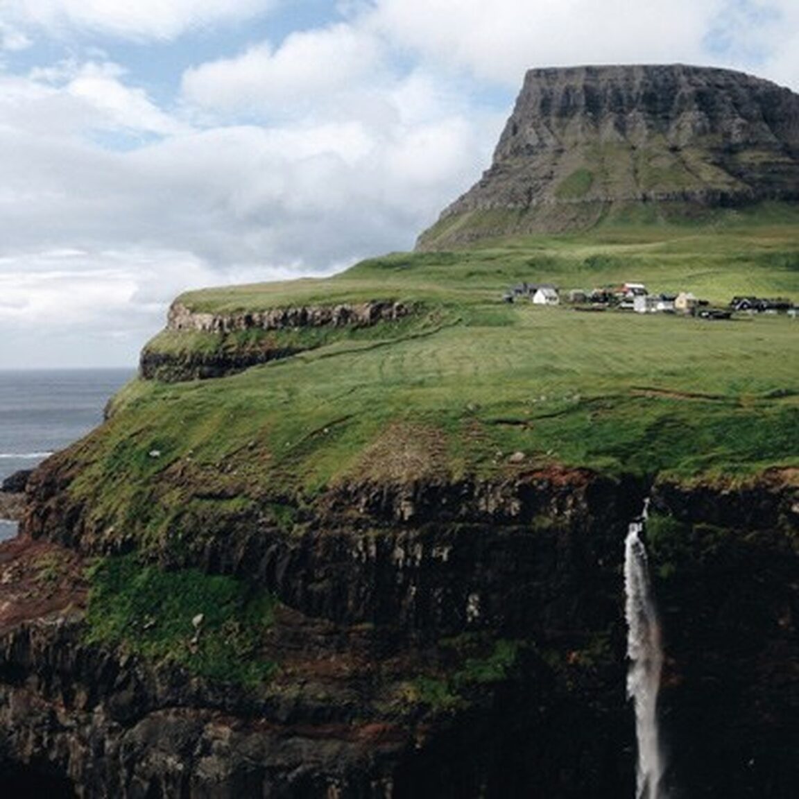
Because Gasadalur rewards the end of the day twice over. First, the history: this was the last village in the Faroes to receive road access, reachable only on foot over the mountain, on the old postman’s path, until the single lane Gasadalstunnilin tunnel opened in 2006, per Visit Faroe Islands. Driving that tunnel at the end of the day, headlights on in the dark bore, and emerging into the goose valley, Gasadalur in Faroese, is the island’s best small drama. Second, the waterfall itself: Mulafossur drops from the stream at the village edge over the cliff into the North Atlantic, framed by the village’s houses and the mountains Arnafjall and Eysturtindur, both over 700 metres. The viewpoint is a short walk, about 300 metres from the trailhead parking and only minutes from the village, inside a cordoned viewing area. In the evening the tour buses have returned to Torshavn, the light rakes across the fjord, and on windy days the falling water blows back up the cliff, which locals treat as normal weather and visitors treat as theatre. Give it a full unhurried hour, walk the village, and drive back through the subsea tunnel to Torshavn in the long northern dusk.
Frequently Asked Questions
How long does a full Vagar day take from Torshavn?
A full circuit in the order this guide sets out takes most of a day: the drive from Torshavn is about 45 minutes each way through the Vagatunnilin subsea tunnel, the Sorvagsvatn and Traelanipa hike takes around 3 hours, and Trollkonufingur, Bour and Gasadalur take about an hour each with stops. Guided full day versions of the same circuit run about 6 hours from a 9 a.m. Torshavn pickup to a 3 p.m. return, per Visit Faroe Islands, and self drivers should allow longer.
Is Mulafossur free to visit?
Yes. The Mulafossur viewpoint at Gasadalur is reached by a short path from the village and trailhead parking and carries no hiking fee. The fee on this route is at the Sorvagsvatn trail to Traelanipa, 200 DKK per person at the trailhead. Keep to the cordoned viewing area at the waterfall cliff.
What is the Gasadalur tunnel like to drive?
The Gasadalstunnilin is a single lane mountain tunnel of about 1.4 kilometres, unlit, opened in 2006 as the village’s first road connection. Drive with headlights on, use the passing places, and take it slowly. Before the tunnel, Gasadalur was reached only on foot over the mountain, which is why the village feels as remote as it does.
Can Vagar be done without a car?
Partially. Public buses run on Vagar and the airport is on the island, and guided day tours from Torshavn cover Gasadalur, Traelanipa and Bosdalafossur in one trip. But the four stop order in this guide, Trollkonufingur to Bour to Gasadalur, depends on leaving each sight when you are ready, and that flexibility is what a rental car buys. In the Faroes, the car is the itinerary.
When is the best season for this Vagar day?
Late spring to early autumn, when the trails are clearest, the Mykines ferry runs from Sorvagur and the evening light lasts for the Gasadalur finale. The sights are open year round, but winter daylight is very short at this latitude and the Traelanipa cliff path in winter wind is a serious undertaking. Whatever the season, bring full waterproofs: Vagar weather changes within the hour.
Featured image: Gasadalur village on its green plateau above the sea cliffs of Vagar, with Mulafossur waterfall dropping from the cliff edge toward the North Atlantic and the flat topped mountain behind the village. Photo by Alexander Mazurov and Anastasia Glebova, from the official Visit Vagar guide published by Visit Faroe Islands (visitfaroeislands.com), used with credit.