 Maya Chen
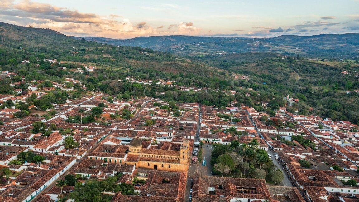
Barichara’s history is not behind glass. It is the street under your shoes. This whitewashed colonial town on a ridge above the Suarez Canyon in Colombia’s Santander department was declared a National Monument in 1978, and the story a traveller walks through here runs in a clear order: a Guane indigenous landscape first, a Spanish colonial town built in local ochre sandstone second, a stone paved Camino Real dropping to the village of Guane third, and a living artisan culture of stone carvers and handmade paper last. Walk it in that order, town, then workshops, then the Camino Real to Guane, and Barichara stops being simply the prettiest town in Colombia and becomes a readable one.
Quick Facts
- Where: Barichara, Santander department, northeastern Colombia, on a ridge above the Suarez Canyon at about 1,300 metres above sea level, reached by road via the adventure town of San Gil.
- Name: Barichara derives from the Guane language and is commonly translated as a place for rest.
- Protection: Declared a National Monument of Colombia in 1978, a designation that protects the historic centre’s architecture.
- Signature material: Piedra barichara, the warm ochre sandstone quarried nearby and used for the cathedral, churches, houses, paving and carved tombs.
- The walk: The Camino Real to Guane, a stone paved path of roughly 9 kilometres in most guide measurements, taking about two to two and a half hours one way, mostly downhill.
- Crafts: Working stone carving studios, and handmade paper made from fique fibre at the town’s paper workshop foundation.
- Facts checked: 17 November 2026, against the Colombia sources cited in this story. Local prices and workshop hours change, so confirm them in town.
Whose Land Was This Before the Colonial Town?
The Guane were here first, and Barichara has not forgotten it. The Guane people, known for agriculture, weaving and pottery, farmed this dry, canyon cut country long before Spanish settlement, and their language survives in the town’s very name. The village at the end of the Camino Real still carries their name, Guane, and its small paleontological and archaeological museum holds Guane artefacts alongside the fossils for which this region of Santander is famous among geologists. Starting the story here matters because the colonial town that followed was not built on empty land. It was built on a network of indigenous paths, including the foot route between what became Barichara and Guane, that the stone Camino Real later formalised.
Local tradition dates the town’s founding to the early 18th century, after a farmer, in the legend retold across Santander, saw an image of the Virgin Mary in a stone. A chapel rose on the spot and a town grew around it, laid out in the Spanish colonial grid of straight stone streets, whitewashed tapia, or rammed earth, walls and clay tile roofs that visitors walk today. The fullest local accounts are gathered in guides such as this Barichara travel guide, which traces the legend, the Guane background and the 1978 monument declaration together.
Why Is Stone the Main Character in Barichara?
Because the town is quite literally made of one stone, and proud of it. Piedra barichara, the golden local sandstone, faces the Cathedral of the Immaculate Conception on the main plaza, paves the streets, builds the smaller chapels such as Santa Barbara on its hill, and fills the cemetery, where generations of the town’s stone carvers, the picapedreros, carved tombs that advertise the trade of the person beneath them: a book for a teacher, tools for a carpenter, in one famous case a stone homage at the cemetery entrance by the sculptor Arsenio Plata. Stone carving here is not a revived heritage performance. The workshops are working businesses, the Parque de las Artes Jorge Delgado Sierra sets contemporary sculpture in the open air, and the warm, fossil flecked stone is the first thing every photograph of the town is actually a photograph of.
The second craft is softer and just as rooted. At the town’s paper workshop, the Fundacion Taller de Papel, artisans make paper by hand from natural fibres, above all fique, the agave family plant woven across Santander into bags, hammocks and rope. Visitors can follow the process from pulped fibre to pressed sheet and buy notebooks and cards in the shop, and the workshop is routinely listed among the most distinctive artisan visits in Colombia, including by Discovering Colombia’s Barichara guide. Together the two crafts state the town’s thesis: everything here is made slowly, by hand, from what the surrounding land provides.
What Does the Camino Real to Guane Actually Walk You Through?
It walks you down through the whole story at boot pace. The Camino Real begins at the edge of Barichara and descends on broad, uneven stone slabs through dry scrub, cactus and farmland, with the Suarez Canyon country opening out as you lose height. The path follows the older Guane route and was rebuilt in stone in the 19th century under the German engineer and road builder Geo von Lengerke, whose network of caminos reales stitched Santander together for mule trade. Distances are quoted between roughly five and a half and nine kilometres depending on the source and the exact start point, so plan on the experience rather than the number: about two to two and a half hours of downhill walking, best started early before the heat builds on the exposed stone, in shoes with real grip.
Guane itself is the reward, a village smaller and quieter than Barichara, gathered around a simple church and plaza, where the museum’s fossils and Guane pieces close the loop the walk opened. Most walkers ride back up by local bus or taxi rather than climbing the path in the afternoon sun. There is no ticket barrier and no booking window for the Camino Real, which is precisely why the order of play matters: walk it on a weekday morning and the path, the village and the museum are at their calmest, then give the following day to the town’s workshops and churches rather than compressing everything into one footsore afternoon.
How Should You Order a Stay in Barichara?
Give it three nights if you can. Day one belongs to the town itself: the cathedral and main plaza, the Santa Barbara chapel viewpoint, the cemetery’s carved stones and the slow circuit of whitewashed streets, ending at a canyon edge mirador as the light warms the sandstone. Day two is the Camino Real to Guane, started early, with the museum at the far end and a ride back. Day three is for making things: the paper workshop, the stone studios and the galleries, with no schedule tighter than lunch. Travellers pairing Barichara with Colombia’s other great colonial towns can set it against our food first take on the capital in the guide to what to eat in Bogota, and anyone building a wider Latin American heritage route will find a kindred, slower pace in our Guanajuato itinerary and the San Cristobal de las Casas itinerary.
Base in the historic centre, inside the monument zone, in one of the courtyard houses converted to small hotels and guesthouses. Barichara has no sights that require transport once you are in town, evenings are quiet by design, and the town’s restaurants cluster within a few streets of the plaza. What it asks of a visitor is the one thing its name promised the Guane centuries ago: rest, taken slowly, in a place built by hand from its own golden stone.
Frequently Asked Questions
How long is the Camino Real from Barichara to Guane?
Sources quote between about five and a half and nine kilometres depending on the measured start and end points. Most walkers take around two to two and a half hours one way, walking downhill from Barichara to Guane, and many return by local bus or taxi. Start early, carry water and wear shoes with grip for the uneven stone slabs.
Why was Barichara declared a National Monument?
Colombia declared Barichara a National Monument in 1978 to protect its exceptionally preserved colonial architecture: stone paved streets, whitewashed rammed earth houses, clay tile roofs and churches built in the local ochre sandstone, all surviving as a coherent historic centre rather than isolated buildings.
What is piedra barichara?
It is the warm, golden sandstone quarried near the town and used across Barichara for the cathedral, churches, house fronts, street paving and carved cemetery tombs. The town’s stone carvers, known as picapedreros, still work it in local studios, and it is the defining material of the town’s appearance.
What happens at the Barichara paper workshop?
At the Fundacion Taller de Papel, artisans make paper by hand from natural fibres, principally fique, and visitors can watch the process from pulping the fibre to pressing the finished sheets, then buy paper goods in the shop. Hours vary, so check locally on arrival and aim for a weekday morning.
How do you get to Barichara?
Barichara is reached by road in Santander, most commonly via San Gil, the region’s transport and adventure hub, from where local buses and taxis climb to the town. There is no airport or rail service in Barichara itself, so every arrival is a road arrival, and the last stretch is part of the experience.
How many days do you need in Barichara?
Three nights is the comfortable answer: one day for the town’s churches, plaza, cemetery and viewpoints, one for the Camino Real walk to Guane and its museum, and one for the paper workshop and stone carving studios. Two nights works if the walk and the town share a well organised first full day.